Category:Marywell, Aboyne
Jump to navigation
Jump to search
English: Marywell is a settlement in the council area of Aberdeenshire, Scotland.
settlement near Aboyne, in Aberdeenshire, Scotland, UK  | |||||
| Upload media | |||||
| Instance of | |||||
|---|---|---|---|---|---|
| Location |
| ||||
 | |||||
Media in category "Marywell, Aboyne"
The following 20 files are in this category, out of 20 total.
-
 Butterworth Gallery, Marywell - geograph.org.uk - 256433.jpg 542 × 640; 90 KB
-
 Sunnyside cottage - geograph.org.uk - 418936.jpg 640 × 480; 84 KB
-
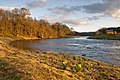 A bend in the river at Kincardine O'Neil - geograph.org.uk - 1219552.jpg 640 × 429; 125 KB
-
 Access to Slidderybrae Wood - geograph.org.uk - 418763.jpg 640 × 480; 126 KB
-
 An entry into Potarch Wood - geograph.org.uk - 419010.jpg 640 × 480; 152 KB
-
 Approach to Mill of Cattie - geograph.org.uk - 604622.jpg 640 × 480; 55 KB
-
 Craigmore trig - geograph.org.uk - 696893.jpg 640 × 480; 128 KB
-
 Forest track in Craigmore Wood - geograph.org.uk - 696915.jpg 640 × 480; 120 KB
-
 Forest track into Craigmore Wood - geograph.org.uk - 418607.jpg 640 × 480; 121 KB
-
 Forestry track in Craigmore Wood - geograph.org.uk - 418580.jpg 480 × 640; 126 KB
-
 Line break through Potarch Wood. - geograph.org.uk - 418605.jpg 640 × 480; 132 KB
-

-
 Mill of Cattie - geograph.org.uk - 418795.jpg 640 × 458; 75 KB
-
 Road Junction at Potarch - geograph.org.uk - 530715.jpg 640 × 480; 111 KB
-
 Road to Mill of Cattie - geograph.org.uk - 418769.jpg 640 × 480; 129 KB
-
 Summit of Craigmore Wood (218m) - geograph.org.uk - 418816.jpg 640 × 480; 99 KB
-
 The Dinnie Stanes - geograph.org.uk - 604637.jpg 640 × 480; 112 KB
-
 The Potarch Hotel - geograph.org.uk - 604675.jpg 640 × 480; 132 KB
-
 Track into Craigmore Wood . - geograph.org.uk - 418993.jpg 480 × 640; 119 KB
-
 Woodland boundary - geograph.org.uk - 418809.jpg 640 × 480; 114 KB


_of_Craigmore_Wood_-_geograph.org.uk_-_418599.jpg)


_-_geograph.org.uk_-_418816.jpg)


