Category:Mason-Dixon Line
Vai alla navigazione
Vai alla ricerca
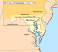
English: The Mason–Dixon Line is a border surveyed in the 1760s in America. This line is still the north and east border of Maryland with Delaware and Pennsylvania.
surveyed border line between U.S. states of Delaware, Maryland, and Pennsylvania  _in_Peach_Bottom_Township,_York_County,_Pennsylvania.jpg) | |||||
| Carica un file multimediale | |||||
| Istanza di |
| ||||
|---|---|---|---|---|---|
| Prende il nome da |
| ||||
| Luogo |
| ||||
| Connesso con |
| ||||
| Autore | |||||
| Creatore |
| ||||
| Consiste di |
| ||||
| Designazione del patrimonio | |||||
 | |||||
Sottocategorie
Questa categoria contiene le 4 sottocategorie indicate di seguito, su un totale di 4.
D
M
File nella categoria "Mason-Dixon Line"
Questa categoria contiene 73 file, indicati di seguito, su un totale di 73.
-
 1864 Johnson's Map of Maryland and Delaware - Geographicus - DEMD-j-64.jpg 2 500 × 2 001; 1,7 MB
-

-

-

-

-

-

-

-

-

-

-

-

-

-

-

-

-

-

-

-

-
-

-

-

-

-

-
-

-

-

-

-

-

-

-

-

-

-

-

-

-
 63 - 20180729 - Monongalia County, WV.jpg 1 530 × 2 040; 1,63 MB
-
 A Plan of the West Line or Parallel of Latitude - WDL.png 2 892 × 1 024; 3,86 MB
-
 Across State Lines (6043118170).jpg 5 184 × 3 456; 2,87 MB
-
 Cresapwarmap.png 500 × 416; 111 KB
-
 Delaware-wedge-pl.png 710 × 813; 7 KB
-
 Flickr - Nicholas T - Highpoint Scenic Vista and Recreation Area (Revisited) (1).jpg 4 608 × 3 456; 11,15 MB
-
 The history of Mason and Dixon's line; (IA historyofmasondi00lat).pdf 814 × 1 350, 68 pagine; 2,91 MB
-
 I-81 North - MM12 - PA163 One Mile.jpg 3 600 × 2 400; 2,67 MB
-
 I-83 nb at Pennsylvania state line, May 2023.jpg 3 290 × 2 251; 1,19 MB
-
 Independence National Historical Park (e7f91e9b-c227-414b-8566-095a112b2fc1).jpg 2 448 × 3 264; 938 KB
-

-
 Map of wedge maryland pennsylvania delaware 1850 survey corps of engineers.png 5 220 × 3 102; 33 MB
-
 Marycolony.png 483 × 433; 28 KB
-
 Maryland State Line - panoramio.jpg 3 968 × 2 976; 2,1 MB
-
 Mason and Dixon cropped.png 822 × 824; 842 KB
-
 Mason and Dixon Line on Us Route 11 - DPLA - 26da77d426bf34260dfecf85b3454315.jpg 6 620 × 5 112; 1,57 MB
-
 Mason and Dixon.png 1 898 × 1 898; 2,37 MB
-
 Mason Dixon Line - panoramio.jpg 320 × 240; 11 KB
-
 Mason Dixon Line - Rail Trail.jpg 2 988 × 5 312; 5,27 MB
-
 Mason-Dixon Crownstone Sign Marydel (31715786388).jpg 2 400 × 1 600; 2,07 MB
-
 Mason-Dixon line on PA-MD border.jpg 872 × 866; 221 KB
-
 Mason-Dixon Survey Historical Marker Front and South Sts Philadelphia PA (DSC 3153).jpg 3 000 × 2 000; 4,79 MB
-
 Mason-dixon-line-pl.GIF 438 × 291; 11 KB
-
 Mason-dixon-line.gif 438 × 291; 11 KB
-
 Mdl (2626498516).jpg 1 615 × 1 197; 348 KB
-
 Report on the resurvey of the Maryland-Pennsylvania boundary part of the Mason and Dixon line (IA reportonresurvey00maso).pdf 802 × 1 310, 600 pagine; 31,64 MB
-
 The great allegheny passage in fall view of wind turbines.jpg 2 592 × 1 936; 1,69 MB
-
 Transpen-line.gif 696 × 502; 16 KB
-
 US 1 nb entering Pennsylvania.jpg 3 414 × 2 028; 1,28 MB
-
 US Route 1 - Maryland (4131434225).jpg 640 × 480; 37 KB
-
 US Route 15 - Maryland (6496442989).jpg 2 816 × 2 112; 412 KB
-
 US Route 15 - Maryland (8134584930).jpg 3 072 × 2 304; 568 KB

_and_the_north_end_of_Maryland_State_Route_165_(Pylesville_Road)_entering_Harford_County,_Maryland_from_York_County,_Pennsylvania.jpg)
_in_Peach_Bottom_Township,_York_County,_Pennsylvania.jpg)
_in_Peach_Bottom_Township,_York_County,_Pennsylvania.jpg)
_and_Pennsylvania_State_Route_74_(Delta_Road)_on_the_border_of_Peach_Bottom_Township,_York_County,_Pennsylvania_and_Cardiff,_Harford_County,_Maryland.jpg)
_and_Pennsylvania_State_Route_74_(Delta_Road)_on_the_border_of_Peach_Bottom_Township,_York_County,_Pennsylvania_and_Cardiff,_Harford_County,_Maryland.jpg)
_crossing_the_Mason-Dixon_line_from_Cumberland_Valley_Township,_Bedford_County,_Pennsylvania_into_Dickens,_Allegany_County,_Maryland.jpg)
_crossing_the_Mason-Dixon_line_from_Dickens,_Allegany_County,_Maryland_into_Cumberland_Valley_Township,_Bedford_County,_Pennsylvania.jpg)
_entering_Dickens,_Allegany_County,_Maryland_from_Cumberland_Valley_Township,_Bedford_County,_Pennsylvania.jpg)
_entering_Cumberland_Valley_Township,_Bedford_County,_Pennsylvania_from_Allegany_County,_Maryland.jpg)
_just_after_crossing_the_Mason-Dixon_Line_from_Londonderry_Township,_Bedford_County,_Pennsylvania_into_Ellerslie,_Allegany_County,_Maryland.jpg)
_after_crossing_from_Allegany_County,_Maryland_into_Wellersburg,_Somerset_County,_Pennsylvania.jpg)
_just_after_crossing_the_Mason-Dixon_Line_from_Wellersburg,_Bedford_County,_Pennsylvania_into_Allegany_County,_Maryland.jpg)
_and_the_north_end_of_Maryland_Route_47_(Barrelville_Road)_entering_Allegany_County,_Maryland_from_Wellersburg,_Somerset_County,_Pennsylvania.jpg)
_becomes_Pennsylvania_State_Route_3001_(York_Road)_as_it_enters_Shrewsbury_Township,_Pennsylvania_from_Maryland_Line,_Maryland.jpg)
_at_the_border_of_Shrewsbury_Township,_Pennsylvania_and_Maryland_Line,_Maryland.jpg)
_becomes_Maryland_State_Route_45_(York_Road)_as_it_enters_Maryland_Line,_Baltimore_County,_Maryland_from_Shrewsbury_Township,_York_County,_Pennsylvania.jpg)
_on_the_border_of_Franklin_County,_Pennsylvania_and_Washington_County,_Maryland.jpg)
_on_the_border_of_Franklin_County,_Pennsylvania_and_Washington_County,_Maryland.jpg)
_entering_Washington_County,_Maryland_from_Washington_Township,_Franklin_County,_Pennsylvania.jpg)
_at_the_border_of_Washington_County,_Maryland_and_Franklin_County,_Pennsylvania.jpg)
_at_the_border_of_Washington_County,_Maryland_and_Franklin_County,_Pennsylvania.jpg)
_and_the_west_end_of_Pennsylvania_Route_163_(Williamsport_Pike)_on_the_border_of_Washington_County,_Maryland_and_Franklin_County,_Pennsylvania.jpg)
_as_it_enters_Middleburg,_Washington_County,_Maryland_from_Antrim_Township,_Franklin_County,_Pennsylvania.jpg)

_and_the_south_end_of_Pennsylvania_State_Route_516_(Lineboro_Road)_crossing_the_Mason-Dixon_Line_from_Lineboro,_Maryland_into_Manheim_Township,_Pennsylvania.jpg)
_and_the_north_end_of_Maryland_State_Route_86_(Main_Street)_crossing_the_Mason-Dixon_Line_from_Manheim_Township,_Pennsylvania_into_Lineboro,_Maryland.jpg)
_and_the_south_end_of_Pennsylvania_State_Route_94_(Baltimore_Pike)_crossing_the_Mason-Dixon_Line_from_Wentz,_Maryland_into_West_Manheim_Township,_Pennsylvania.jpg)
_and_the_north_end_of_Maryland_State_Route_30_(Hanover_Pike)_crossing_the_Mason-Dixon_Line_from_West_Manheim_Township,_Pennsylvania_into_Wentz,_Maryland.jpg)
_and_the_south_end_of_Pennsylvania_State_Route_194_(Frederick_Pike)_crossing_from_Carroll_County,_Maryland_to_Adams_County,_Pennsylvania.jpg)
_and_the_south_end_of_Pennsylvania_State_Route_194_(Frederick_Pike)_crossing_from_Carroll_County,_Maryland_to_Adams_County,_Pennsylvania.jpg)
_and_the_north_end_of_Maryland_State_Route_194_(Francis_Scott_Key_Highway)_crossing_from_Adams_County,_Pennsylvania_to_Carroll_County,_Maryland.jpg)
_entering_Maugansville,_Washington_County,_Maryland_from_Antrim_Township,_Franklin_County,_Pennsylvania.jpg)
_in_Maugansville,_Washington_County,_Maryland,_just_before_crossing_into_Antrim_Township,_Franklin_County,_Pennsylvania.jpg)


_just_after_entering_Strawn,_Garrett_County,_Maryland_from_Addison_Township,_Somerset_County,_Pennsylvania.jpg)
_and_the_south_end_of_Pennsylvania_Route_841_(Chesterville_Road)_entering_Elk_Township,_Chester_County,_Pennsylvania_from_Fair_Hill,_Cecil_County,_Maryland.jpg)
_and_the_north_end_of_Maryland_Route_213_(Lewisville_Road)_entering_Fair_Hill,_Cecil_County,_Maryland_from_Elk_Township,_Chester_County,_Pennsylvania.jpg)

.jpg)


_(1).jpg)


.jpg)
_(14784178202).jpg)


.jpg)

.jpg)

.jpg)


.jpg)
.jpg)
.jpg)
Categorie:
- State lines
- Geography of Delaware
- Geography of Maryland
- Geography of Pennsylvania
- Surveying in the United States
- 1760s establishments in the United States
- History of the Thirteen Colonies
- Geographic history of the United States
- National Historic Civil Engineering Landmarks
- National Historic Civil Engineering Landmarks in Maryland
- National Historic Civil Engineering Landmarks in Pennsylvania
- Cresap's War
- Maryland-Pennsylvania border