Category:Mauritskade 27, The Hague
Jump to navigation
Jump to search
| Object location | | View all coordinates using: OpenStreetMap |
|---|
house in The Hague, Netherlands  | |||||
| Upload media | |||||
| Instance of | |||||
|---|---|---|---|---|---|
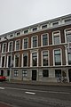
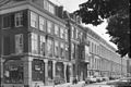
| Location | The Hague, South Holland, Netherlands | ||||
| Street address |
| ||||
| Located on street | |||||
| Heritage designation |
| ||||
 | |||||
|
This is a category about rijksmonument number 17769
|
| Address |
|
Media in category "Mauritskade 27, The Hague"
The following 7 files are in this category, out of 7 total.
-
 Achtergevel - 's-Gravenhage - 20089179 - RCE.jpg 1,200 × 962; 266 KB
-
 Achtergevel - 's-Gravenhage - 20089180 - RCE.jpg 1,200 × 961; 265 KB
-
 Den Haag - Mauritskade 27.JPG 3,056 × 4,592; 3.76 MB
-
 Gevel - 's-Gravenhage - 20089177 - RCE.jpg 1,200 × 966; 286 KB
-
 Gevel - 's-Gravenhage - 20089178 - RCE.jpg 1,200 × 955; 281 KB
-

-
 Overzicht - 's-Gravenhage - 20089175 - RCE.jpg 1,200 × 802; 188 KB


