Category:May 1. Clothing factory
Jump to navigation
Jump to search
| Object location | | View all coordinates using: OpenStreetMap |
|---|
former Hungarian garment factory | |||||
| Upload media | |||||
| Instance of | |||||
|---|---|---|---|---|---|
| Industry | |||||
| Location | Budapest District VIII, Budapest, Hungary | ||||
| Dissolved, abolished or demolished date |
| ||||
 | |||||
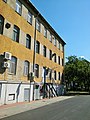
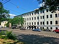
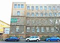
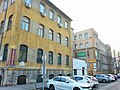
Magyar: Volt Május 1. Ruhagyár, később Elegant Május 1. Ruhagyár (1958 és 1994 között működött). Az épület kezdetben Magyar Királyi Honvédségi Ruharaktárnak épült 1895 előtt (1895-ös térképen már szerepel), majd az 1930-as évektől katonai ruhagyár is működött benne — 1089 Budapest, Elnök utca 1. (a többi oldalról a Szenes Iván tér (korábban Rezső tér), a Batsányi utca, és az Orczy út veszi körül az épületegyüttest)
Media in category "May 1. Clothing factory"
The following 31 files are in this category, out of 31 total.
-
 Batsányistrasse, Waffenladen, 2023 Józsefváros.jpg 1,677 × 2,236; 675 KB
-
 Elnökstrasse und Szenes Iván Platz Ecke, 2023 Józsefváros.jpg 2,186 × 1,640; 827 KB
-
 Hundezone, Szenes Iván Platz 10, 2023 Józsefváros.jpg 2,272 × 1,704; 990 KB
-
 Május 1. Ruhagyár 2022 szeptembere1.jpg 2,448 × 3,264; 1.91 MB
-
 Május 1. Ruhagyár 2022 szeptembere10.jpg 3,264 × 2,448; 2.69 MB
-
 Május 1. Ruhagyár 2022 szeptembere11.jpg 3,264 × 2,448; 2.36 MB
-
 Május 1. Ruhagyár 2022 szeptembere2.jpg 2,448 × 3,264; 2.33 MB
-
 Május 1. Ruhagyár 2022 szeptembere3.jpg 2,415 × 3,219; 2.17 MB
-
 Május 1. Ruhagyár 2022 szeptembere4.jpg 3,211 × 2,409; 2.11 MB
-
 Május 1. Ruhagyár 2022 szeptembere5.jpg 3,264 × 2,448; 2.37 MB
-
 Május 1. Ruhagyár 2022 szeptembere6.jpg 3,161 × 2,371; 1.91 MB
-
 Május 1. Ruhagyár 2022 szeptembere7.jpg 3,264 × 2,448; 2.37 MB
-
 Május 1. Ruhagyár 2022 szeptembere8.jpg 2,448 × 3,264; 2.3 MB
-
 Május 1. Ruhagyár 2022 szeptembere9.jpg 2,448 × 3,264; 2.09 MB
-
 Május 1. Ruhagyár1.jpg 3,264 × 1,649; 1.24 MB
-
 Május 1. Ruhagyár10.jpg 3,149 × 2,361; 1.87 MB
-
 Május 1. Ruhagyár11.jpg 3,264 × 1,810; 1.93 MB
-
 Május 1. Ruhagyár12.jpg 3,264 × 2,448; 2.45 MB
-
 Május 1. Ruhagyár13.jpg 3,161 × 1,751; 1.5 MB
-
 Május 1. Ruhagyár14.jpg 3,264 × 1,177; 1.08 MB
-
 Május 1. Ruhagyár15.jpg 3,264 × 2,448; 2.34 MB
-
 Május 1. Ruhagyár16.jpg 3,183 × 2,387; 1.95 MB
-
 Május 1. Ruhagyár17.jpg 3,264 × 2,448; 2.07 MB
-
 Május 1. Ruhagyár2.jpg 3,264 × 2,448; 2.35 MB
-
 Május 1. Ruhagyár3.jpg 3,264 × 2,312; 1.81 MB
-
 Május 1. Ruhagyár4.jpg 3,264 × 2,334; 2.2 MB
-
 Május 1. Ruhagyár5.jpg 3,264 × 2,448; 2.02 MB
-
 Május 1. Ruhagyár6.jpg 3,264 × 2,448; 2.27 MB
-
 Május 1. Ruhagyár7.jpg 3,264 × 1,525; 887 KB
-
 Május 1. Ruhagyár8.jpg 2,086 × 1,223; 998 KB
-
 Május 1. Ruhagyár9.jpg 3,264 × 2,448; 2.77 MB


