Category:Mechthildisstraße 16 (Hennef)
Jump to navigation
Jump to search
| Object location | | View all coordinates using: OpenStreetMap |
|---|
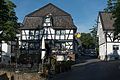
| This category shows a heritage building in Germany, located in the North Rhine-Westphalian city Hennef (Sieg) (no. A 38). |
Media in category "Mechthildisstraße 16 (Hennef)"
The following 3 files are in this category, out of 3 total.
-
 Hennef (Sieg), Stadt Blankenberg, Mechthildisstraße 16-20160608-001.jpg 4,016 × 6,016; 8.72 MB
-
 Hennef (Sieg), Stadt Blankenberg, Mechthildisstraße 16-20160608-002.jpg 6,016 × 4,016; 12.23 MB
-
 Hennef Blankenberg, Mechthildisstraße 16.jpg 4,032 × 2,272; 6.52 MB
,_Stadt_Blankenberg,_Mechthildisstra%C3%9Fe_16-20160608-001.jpg)
,_Stadt_Blankenberg,_Mechthildisstra%C3%9Fe_16-20160608-002.jpg)