Category:Media from Atlas of Mutual Heritage on Dutch East India Company
Jump to navigation
Jump to search
Media in category "Media from Atlas of Mutual Heritage on Dutch East India Company"
The following 200 files are in this category, out of 488 total.
(previous page) (next page)-
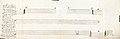
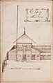
 AMH-2488-NA Construction drawings of buildings at the Cape of Good Hope.jpg 2,400 × 1,761; 499 KB
-
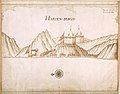
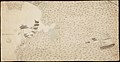
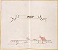
 AMH-2507-NA Map of the harbour of the city of Mocha.jpg 2,400 × 1,888; 652 KB
-
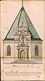
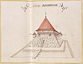
 AMH-2546-NA Elevation of the Fort of Good Hope.jpg 2,400 × 1,520; 472 KB
-
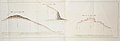
 AMH-2551-NA Sea level panorama from Table Bay to Saldanha Bay.jpg 2,400 × 963; 255 KB
-
 AMH-2573-NA Representation of the fort on the island of Kismis.jpg 2,400 × 1,841; 920 KB
-
 AMH-2582-NA View of the fort at Mangalor.jpg 2,400 × 1,643; 318 KB
-
 AMH-2585-NA Plan to reduce the fort at Cananoor.jpg 1,859 × 2,400; 670 KB
-
 AMH-2601-NA Elevations of the fortifications to the west and south of Cochin.jpg 2,400 × 933; 239 KB
-
 AMH-2625-NA Representation of the lodge at Amadabat.jpg 2,400 × 1,517; 608 KB
-
 AMH-2628-NA Representation of the lodge of the Company at Agra.jpg 2,400 × 1,821; 516 KB
-
-
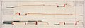
 AMH-3181-NA Maps and elevations for hydro-engineering works on the River in Batavia.jpg 2,400 × 1,699; 426 KB
-
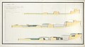
 AMH-4197-NA Sea levels from Table Bay to Saldanha Bay.jpg 2,400 × 942; 276 KB
-
 AMH-4201-NA Map of Negumbo.jpg 1,543 × 2,400; 386 KB
-
 AMH-4202-NA Elevations for the fortification of the castle at Colombo.jpg 2,400 × 930; 202 KB
-
 AMH-4212-NA Map of Belligam.jpg 1,531 × 2,400; 408 KB
-
 AMH-4221-NA Sea levels from Table Bay to Saldanha Bay.jpg 2,400 × 973; 285 KB
-
 AMH-4222-NA Sea levels from Table Bay to Saldanha Bay.jpg 2,400 × 907; 282 KB
-
 AMH-4223-NA Maps and elevations for water works on the 'Groote Rivier' in Batavia.jpg 2,400 × 1,671; 501 KB
-
 AMH-4481-NA Maps and elevations for waterworks on the 'Groote Rivier' at Batavia.jpg 2,400 × 1,685; 404 KB
-
 AMH-4486-NA Front and rear of the governor's house at Colombo.jpg 9,757 × 7,195; 11.3 MB
-
 AMH-4498-NA View of the training college at Naloer.jpg 2,400 × 1,708; 557 KB
-
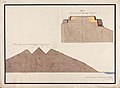
 AMH-4501-NA Elevation of Trinconomale.jpg 2,400 × 774; 160 KB
-
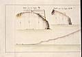
 AMH-4506-NA Profiles of the fort at Trinconomale.jpg 2,400 × 940; 228 KB
-
 AMH-4509-NA Elevations of the fort at Trinconomale.jpg 2,400 × 1,348; 412 KB
-
 AMH-4516-NA Profiles of the fort at Trinconomale.jpg 2,400 × 856; 218 KB
-

-
 AMH-4533-NA Gate of the Van Eck redoubt at Mature.jpg 2,400 × 1,068; 467 KB
-
 AMH-4540-NA Profiles of the fort at Gale.jpg 2,400 × 534; 131 KB
-
 AMH-4542-NA Profiles of the fort at Gale.jpg 2,400 × 728; 196 KB
-
 AMH-4558-NA Elevations of Fort De Vyf Sinnen at Nagapatnam.jpg 1,683 × 2,400; 515 KB
-
 AMH-4583-NA Map and elevations of the castle at Batavia.jpg 2,400 × 868; 208 KB
-
 AMH-4606-NA View of the office at Soecawayana.jpg 2,400 × 430; 237 KB
-
 AMH-4614-NA View of the mines at Sillida.jpg 2,400 × 1,651; 945 KB
-
 AMH-4619-NA View of the city of Palembang.jpg 2,400 × 1,681; 673 KB
-
 AMH-4621-NA Map of the 'pagger' near the lodge at Jambi.jpg 2,400 × 779; 171 KB
-
 AMH-4623-NA View of the bay at Firando.jpg 2,400 × 1,711; 568 KB
-
 AMH-4639-NA View of the general's residence within the castle at Batavia.jpg 2,400 × 1,735; 733 KB
-
 AMH-4640-NA View of the general's residence at the castle at Batavia.jpg 2,400 × 1,762; 718 KB
-
 AMH-4641-NA Diestpoort at Batavia.jpg 1,621 × 2,400; 591 KB
-
 AMH-4642-NA The chapel at Batavia Castle.jpg 1,328 × 2,400; 550 KB
-
 AMH-4648-NA Construction drawing for the silk factory in Batavia.jpg 2,400 × 1,148; 346 KB
-
 AMH-4671-NA Fort Belvidere at Sourabaya.jpg 2,400 × 1,922; 926 KB
-
 AMH-4675-NA View of the island of Solor and Fort Henricus.jpg 2,400 × 1,840; 720 KB
-
 AMH-4676-NA View of Fort Henricus.jpg 2,400 × 1,860; 699 KB
-
 AMH-4677-NA View of Fort Concordia at Coupan.jpg 2,400 × 1,825; 845 KB
-
 AMH-4678-NA Maps and profiles for waterworks in the 'Groote Rivier' in Batavia.jpg 2,400 × 1,669; 390 KB
-

-
 AMH-4685-NA View of the fort on the island of Bouton.jpg 2,400 × 1,896; 883 KB
-
 AMH-4691-NA The ruined fort at Gammelamme.jpg 2,400 × 1,601; 599 KB
-
 AMH-4692-NA View of the forts of Mauritius and Gnofficquia on Macquian.jpg 2,400 × 1,833; 725 KB
-
 AMH-4693-NA Bird's eye view of Fort Tafashoho on Macquian.jpg 2,400 × 1,870; 587 KB
-
 AMH-4694-NA The Tabelolo redoubt at Macquian.jpg 2,400 × 1,913; 600 KB
-
 AMH-4706-NA The Passe redoubt at Amboina.jpg 2,400 × 1,897; 612 KB
-
 AMH-4710-NA Governor's house at Amboina.jpg 2,400 × 1,681; 567 KB
-
 AMH-4712-NA Cambello on the Seram peninsula.jpg 2,400 × 1,807; 711 KB
-
 AMH-4713-NA The Hardenburg Fort on Cambello mountain.jpg 2,400 × 1,819; 904 KB
-
 AMH-4714-NA Fort Hardenberg on Cambello mountain.jpg 2,400 × 1,827; 988 KB
-
 AMH-4715-NA Hardenberg fort on Cambello mountain.jpg 2,400 × 1,878; 761 KB
-
 AMH-4720-NA The forts of Nassau and Belgica and the Neira redoubt on Banda Neira.jpg 2,400 × 1,905; 858 KB
-
 AMH-4723-NA View of the island of Neira.jpg 2,400 × 1,726; 527 KB
-
 AMH-4726-NA The lodge at Lonthor.jpg 2,400 × 1,855; 569 KB
-
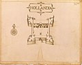 AMH-4727-NA Fort Hollandia on Lonthor.jpg 2,400 × 1,905; 623 KB
-
 AMH-4730-NA Fort at Waijer.jpg 2,400 × 1,914; 565 KB
-

-
 AMH-4735-NA Views of the islands of Goenong Api and Rosingyn.jpg 1,697 × 2,400; 535 KB
-
 AMH-4736-NA View of the redoubt at Rosingyn.jpg 2,400 × 1,826; 936 KB
-
 AMH-4739-NA Elevations of the fortifications at Trincomalee.jpg 2,400 × 239; 49 KB
-
 AMH-4742-NA View of Gamron.jpg 2,400 × 1,696; 400 KB
-
 AMH-4747-NA Map and elevations of Fort Oostenburg.jpg 2,400 × 1,595; 494 KB
-

-
 AMH-4771-KB The Batavia fishmarket.jpg 2,400 × 2,058; 641 KB
-
 AMH-4802-KB The Dutch church or 'Kruiskerk' at Batavia.jpg 2,400 × 2,012; 613 KB
-
 AMH-4803-KB The city hall on Batavia.jpg 2,400 × 1,951; 644 KB
-
 AMH-4804-KB The spinning house at Batavia.jpg 2,400 × 1,995; 653 KB
-
 AMH-4805-KB The slaughterhouse at Batavia.jpg 2,400 × 1,965; 560 KB
-
 AMH-4806-KB The orphanage at Batavia.jpg 2,400 × 2,034; 616 KB
-
 AMH-4828-NA Map of Ceylon and the coast of Madure.jpg 2,400 × 1,845; 804 KB
-
 AMH-5103-NA Map of Lagoa Bay.jpg 2,400 × 2,217; 623 KB
-
 AMH-5158-NA Chart of soundings in the river at Batavia.jpg 2,400 × 1,636; 500 KB
-
 AMH-5179-NA Vessel from the Japanese region.jpg 1,799 × 2,400; 389 KB
-
 AMH-5180-NA Vessel from the Japanese region.jpg 2,400 × 1,813; 449 KB
-
 AMH-5342-NA View of Basra and 'Gordelaan' castle (cropped).jpg 2,305 × 857; 237 KB
-
 AMH-5342-NA View of Basra and 'Gordelaan' castle.jpg 2,400 × 1,652; 546 KB
-
 AMH-5355-NA Side views of the fort at Cochin.jpg 2,400 × 1,886; 427 KB
-
 AMH-5365-NA Plan for alterations to the castle at Colombo.jpg 2,400 × 1,113; 259 KB
-
 AMH-5366-NA Plan for alterations to the castle at Colombo.jpg 2,400 × 1,644; 380 KB
-
 AMH-5370-NA Plan for alterations to the castle at Colombo.jpg 2,400 × 1,437; 407 KB
-
 AMH-5371-NA Drawing of a powder mill.jpg 1,711 × 2,400; 543 KB
-
 AMH-5374-NA Profile of the fortifications at Jaffna.jpg 2,400 × 1,687; 422 KB
-
 AMH-5375-NA Drawing of a powder mill.jpg 2,400 × 1,682; 534 KB
-
 AMH-5380-NA Cross-section of a mountain near Oostenburg.jpg 2,400 × 1,758; 473 KB
-
 AMH-5384-NA Profile of the fortifications at Galle.jpg 2,400 × 1,567; 345 KB
-
 AMH-5400-NA Profile of the 'Faussebraye' at Hougli.jpg 2,400 × 1,494; 353 KB
-
 AMH-5401-NA The church at Malakka relative to the bastion there.jpg 1,594 × 2,400; 658 KB
-
 AMH-5404-NA Profiles relating to the fort of Tranquera at Melaka.jpg 2,400 × 1,615; 380 KB
-
 AMH-5405-NA Profiles relating to the fort of Tranquera at Melaka.jpg 2,400 × 1,609; 440 KB
-
 AMH-5406-NA Profiles relating to the fort of Tranquera at Melaka.jpg 2,400 × 1,651; 330 KB
-
 AMH-5407-NA Profiles relating to the fort of Tranquera at Melaka.jpg 2,400 × 1,611; 321 KB
-
 AMH-5408-NA Profiles relating to the fort of Tranquera at Melaka.jpg 2,400 × 1,650; 462 KB
-
 AMH-5409-NA Profiles relating to the fort of Tranquera at Melaka.jpg 2,400 × 1,638; 372 KB
-
 AMH-5410-NA Profiles relating to the fort of Tranquera at Melaka.jpg 2,400 × 1,588; 393 KB
-
 AMH-5411-NA Profiles relating to the fort of Tranquera at Melaka.jpg 2,400 × 1,626; 435 KB
-
 AMH-5412-NA Profiles relating to the fort of Tranquera at Melaka.jpg 2,400 × 1,618; 451 KB
-
 AMH-5415-NA Landscape on Mauritius, named 'De vuyle bocht'.jpg 2,400 × 1,699; 584 KB
-
 AMH-5459-NA Sketch of the Vijfhoek post.jpg 2,400 × 1,686; 400 KB
-
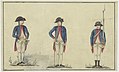 AMH-5460-NA Uniform for VOC soldiers.jpg 3,700 × 2,232; 1.33 MB
-

-

-
 AMH-5523-NA Map of Sumatra and the Malacca Straits.jpg 2,149 × 2,400; 929 KB
-
 AMH-5560-NA Plan for alterations to the castle at Colombo.jpg 2,400 × 807; 206 KB
-
 AMH-5561-NA Plan for alterations to the castle at Colombo.jpg 2,400 × 1,031; 223 KB
-
 AMH-5565-NA Profiles for planned improvements to the castle at Colombo.jpg 2,400 × 914; 229 KB
-
 AMH-5566-NA Profiles for planned improvements to the castle at Colombo.jpg 2,400 × 914; 220 KB
-
 AMH-5574-NA Cross-section of part of the fort at Galle.jpg 2,400 × 752; 156 KB
-
 AMH-5626-NA Bird's eye view of the city of Judja.jpg 2,400 × 1,591; 796 KB
-
 AMH-5637-KB The court of the great Mogul.jpg 2,400 × 1,946; 868 KB
-
 AMH-5642-KB View of the Nieuwe Poort at Batavia.jpg 2,400 × 1,856; 568 KB
-
 AMH-5643-KB View of the Tijgersgracht on Batavia.jpg 2,400 × 1,882; 536 KB
-
 AMH-5644-KB The conquest of Macassar by Speelman from 1666 to 1669.jpg 2,400 × 1,756; 713 KB
-
 AMH-5647-KB Map of Hocsieu, China.jpg 2,400 × 1,020; 318 KB
-
 AMH-6060-NA Design for the Sterrenschans fort near Batavia.jpg 2,400 × 2,096; 673 KB
-
 AMH-6061-NA Fort Zoutelande, near Batavia.jpg 2,400 × 1,686; 433 KB
-
 AMH-6069-NA Bird's eye view of Trinconomale.jpg 2,400 × 1,247; 389 KB
-
 AMH-6070-NA Profiles of fort Oostenburg.jpg 2,400 × 814; 122 KB
-
 AMH-6073-NA Profile of the fortifications at Galle, part B.jpg 2,400 × 1,311; 232 KB
-
 AMH-6074-NA Drawing of a spooling machine in Bengal.jpg 2,400 × 1,934; 661 KB
-
 AMH-6093-NA Map of Ternate, Tidore, Halmaheira or Batachina, Maqjan, Batchian etc..jpg 2,400 × 1,195; 461 KB
-
 AMH-6094-NA View of mountains behind the Cape of Good Hope.jpg 2,400 × 752; 169 KB
-
 AMH-6095-NA Map of the mountains on the Cape of Good Hope.jpg 2,400 × 1,208; 436 KB
-
 AMH-6103-NA Cross-section of a dyke at Cochin.jpg 2,400 × 865; 110 KB
-
 AMH-6105-NA Map of Cattoecare, or the 'Reuzentank' (giant tank) near Colombo.jpg 1,360 × 2,400; 300 KB
-
 AMH-6110-NA Map of the castle of Colombo.jpg 2,400 × 2,329; 627 KB
-
 AMH-6111-NA Map of the castle of Colombo.jpg 2,400 × 2,171; 527 KB
-
 AMH-6112-NA Map of the castle of Colombo.jpg 2,400 × 2,095; 434 KB
-
 AMH-6116-NA Cross-sections of the fortifications, Colombo, part A.jpg 2,400 × 360; 67 KB
-
 AMH-6117-NA Cross-sections of the fortifications, Colombo, part B.jpg 2,400 × 357; 72 KB
-
 AMH-6118-NA Plan for alterations to the fort of Colombo, part F.jpg 2,400 × 569; 125 KB
-
 AMH-6119-NA Plan of alterations to the fort at Colombo, part G.jpg 2,400 × 323; 54 KB
-
 AMH-6120-NA Cross sections for improvements to the fort at Colombo, part B.jpg 2,400 × 720; 151 KB
-
 AMH-6121-NA Cross sections for improvements to the fort at Colombo, part G.jpg 2,400 × 705; 171 KB
-
 AMH-6122-NA Cross sections for improvements to the fort at Colombo, part H.jpg 2,400 × 747; 183 KB
-
 AMH-6123-NA Cross sections of the fortifications at Jaffna, part A.jpg 2,400 × 408; 62 KB
-
 AMH-6124-NA Cross section of the fortifications at Jaffna, part C.jpg 2,400 × 425; 83 KB
-
 AMH-6125-NA Cross section of the fortifications at Trincomalee, part B.jpg 2,400 × 411; 71 KB
-
 AMH-6126-NA Cross sections of the fortifications at Trincomalee, part C.jpg 2,400 × 390; 81 KB
-
 AMH-6127-NA Cross section of the fortifications at Trincomalee, part D.jpg 2,400 × 440; 80 KB
-
 AMH-6128-NA Cross section of the fortificatiions of Oostenburgh, part B.jpg 2,400 × 471; 74 KB
-
 AMH-6130-NA View of Ambon.jpg 2,400 × 1,579; 457 KB
-
 AMH-6132-NA Bird's eye view of the city of Atjeh.jpg 2,400 × 1,677; 564 KB
-
 AMH-6133-NA View of Batticaloa.jpg 2,400 × 2,020; 604 KB
-
 AMH-6134-NA Bird's eye view of the fort of Batticaloa.jpg 2,400 × 1,938; 895 KB
-
 AMH-6135-NA View of Batavia.jpg 2,400 × 1,883; 787 KB
-
 AMH-6136-NA View of Batavia.jpg 2,400 × 1,084; 427 KB
-
 AMH-6138-NA View of Table Bay.jpg 2,400 × 1,651; 536 KB
-
 AMH-6141-NA Cross-sections for improvements to the fort at Colombo, part D.jpg 2,400 × 1,452; 290 KB
-
 AMH-6144-NA View of the city of Cananor.jpg 2,400 × 1,933; 619 KB
-
 AMH-6145-NA View of Canton.jpg 2,400 × 1,636; 518 KB
-
 AMH-6146-NA Bird's eye view of Eauweck, Cambodia.jpg 2,400 × 1,785; 591 KB
-
 AMH-6147-NA View of Cefala.jpg 2,400 × 1,785; 554 KB
-
 AMH-6151-NA View of the city of Dabul.jpg 2,400 × 1,848; 510 KB
-
 AMH-6153-NA Bird's eye view of Negombo.jpg 2,400 × 1,892; 909 KB
-
 AMH-6154-NA View of the city of Jaffna.jpg 2,400 × 1,649; 606 KB
-
 AMH-6156-NA Map of the city of Malakka.jpg 2,400 × 1,113; 368 KB
-
 AMH-6157-NA The conquest of Macassar by Speelman from 1666 to 1669.jpg 6,589 × 4,786; 10.81 MB
-
 AMH-6158-NA Picture of the Osacca castle.jpg 2,400 × 1,696; 849 KB
-
 AMH-6159-NA View of Galle.jpg 2,400 × 1,740; 408 KB
-
 AMH-6161-NA Bird's eye view of the city of Samboppe, Macassar.jpg 2,400 × 1,715; 636 KB
-
 AMH-6162-NA Bird's eye view of the city of Samboppe, Macassar.jpg 2,400 × 1,750; 524 KB
-
 AMH-6164-NA View of Visiapour (according to the title), depicted is Suratte.jpg 2,400 × 1,802; 474 KB
-
 AMH-6165-NA Bird's eye view of Bandanaira.jpg 2,400 × 1,828; 463 KB
-
 AMH-6166-NA Bird's eye view of Colombo and environs.jpg 2,400 × 1,718; 620 KB
-

-
 AMH-6391-NA Maps and cross-sections for waterworks on the river at Batavia.jpg 2,400 × 1,005; 134 KB
-
 AMH-6393-NA View of the fort at Onrust.jpg 2,400 × 2,091; 450 KB
-
 AMH-6394-NA View of the fort at Onrust.jpg 2,400 × 1,639; 381 KB
-
 AMH-6395-NA View of the Jacatra redoubt near Batavia.jpg 2,400 × 1,703; 400 KB
-
 AMH-6396-NA View of the Batenburgh redoubt near Batavia.jpg 2,400 × 1,852; 510 KB
-
 AMH-6397-NA View of the Vijfhoek redoubt near Batavia.jpg 2,400 × 2,032; 563 KB
-
 AMH-6398-NA View of the army camp at Batavia.jpg 2,400 × 2,154; 492 KB
-
 AMH-6399-NA View of the Rijswijk redoubt.jpg 2,400 × 1,461; 373 KB
-
 AMH-6402-NA Bird's eye view of Fort Victoria, Ambon.jpg 2,400 × 2,042; 693 KB
-
 AMH-6405-NA The lodge on Tanimbar.jpg 1,541 × 2,400; 472 KB
-
 AMH-6417-NA View of Taiowan.jpg 2,400 × 1,442; 495 KB
-

-
-

-
 AMH-6437-NA Design for a hospital at the Cape of Good Hope.jpg 2,400 × 1,771; 446 KB
-
 AMH-6439-NA Intoroduction to 31 charts of Ceylon.jpg 2,400 × 1,913; 490 KB
-
 AMH-6462-KB The De Houtman expedition meets the residents of the Cape of Good Hope.jpg 2,400 × 1,900; 921 KB
-
 AMH-6463-KB Meeting with the village chief of Dampin, Sumatra, Sunda Straits.jpg 2,400 × 1,845; 931 KB
-

-
 AMH-6465-KB Dutch leave Bantam harbour.jpg 2,400 × 1,832; 933 KB
-
 AMH-6467-KB Bird's eye view of Bantam.jpg 2,400 × 1,464; 703 KB
-
 AMH-6468-KB East Indiamen in the Palabuan Strait.jpg 2,400 × 1,785; 826 KB
-
 AMH-6470-KB Battle near Bantam between Wolfert Harmensz against the Portuguese.jpg 2,400 × 1,812; 790 KB
-
 AMH-6471-KB Battle near Malacca waged by Cornelis Matelief, 1606.jpg 2,400 × 1,816; 754 KB
-
 AMH-6472-KB Battle for Malacca between the VOC fleet and the Portuguese, 1606.jpg 2,400 × 1,795; 904 KB
-
 AMH-6473-KB Battle for Malacca between the VOC fleet and the Portuguese, 1606.jpg 2,400 × 1,804; 781 KB
-
 AMH-6474-KB View of Gamme Lamme on Ternate.jpg 2,400 × 1,696; 825 KB


_near_Colombo.jpg)


,_depicted_is_Suratte.jpg)


.jpg)