Category:Meigle, North Ayrshire
Jump to navigation
Jump to search
hamlet in North Ayrshire, Scotland, UK  | |||||
| Upload media | |||||
| Instance of | |||||
|---|---|---|---|---|---|
| Location | North Ayrshire, Scotland | ||||
 | |||||
Media in category "Meigle, North Ayrshire"
The following 38 files are in this category, out of 38 total.
-
 A ship heading up the Firth of Clyde - geograph.org.uk - 5808500.jpg 1,024 × 768; 110 KB
-
 Basking seal - geograph.org.uk - 5808504.jpg 1,024 × 509; 165 KB
-
 Beach at Low Spring Tide, Meigle Bay - geograph.org.uk - 4859843.jpg 1,024 × 668; 152 KB
-
 Eglinton Terrace - geograph.org.uk - 3361424.jpg 480 × 640; 200 KB
-
 Flood gate at Skelmorlie - geograph.org.uk - 3369448.jpg 640 × 480; 127 KB
-
 Former church at Meigle - geograph.org.uk - 441632.jpg 640 × 480; 127 KB
-
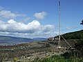 Measured Mile marker at Meigle - geograph.org.uk - 441590.jpg 640 × 480; 81 KB
-
 Meigle - geograph.org.uk - 736152.jpg 640 × 569; 246 KB
-
 Meigle Bay - geograph.org.uk - 3493128.jpg 1,920 × 1,280; 1.25 MB
-
 Meigle Bay and Skelmorlie - geograph.org.uk - 944199.jpg 640 × 480; 97 KB
-
 Meigle Bay on the Ayrshire coast - geograph.org.uk - 3573579.jpg 1,024 × 682; 177 KB
-
 Post Box - geograph.org.uk - 440719.jpg 480 × 640; 144 KB
-
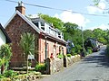 Road through Meigle - geograph.org.uk - 735383.jpg 640 × 480; 213 KB
-
 Road to Upper Skelmorlie - geograph.org.uk - 1039603.jpg 640 × 480; 43 KB
-
 Rock armour at Skelmorlie seafront - geograph.org.uk - 5808512.jpg 1,024 × 768; 410 KB
-
 Seaweed harvest - geograph.org.uk - 1557720.jpg 640 × 480; 103 KB
-
 Shore at Meigle Bay - geograph.org.uk - 1075196.jpg 640 × 496; 139 KB
-
 Shore Road Skelmorlie - geograph.org.uk - 3563225.jpg 640 × 342; 108 KB
-
 Shore Road, Skelmorlie - geograph.org.uk - 3669844.jpg 1,024 × 680; 123 KB
-
 Skelmorlie - geograph.org.uk - 5294633.jpg 640 × 480; 134 KB
-
 Skelmorlie and the Firth of Clyde - geograph.org.uk - 5294655.jpg 640 × 480; 94 KB
-
 Skelmorlie Measured Mile - geograph.org.uk - 3369405.jpg 480 × 640; 119 KB
-
 Skelmorlie Measured Mile - geograph.org.uk - 3369433.jpg 480 × 640; 122 KB
-
 Skelmorlie Water - geograph.org.uk - 3361416.jpg 640 × 480; 150 KB
-
 Skelmorlie Water - geograph.org.uk - 3361418.jpg 640 × 429; 167 KB
-
 The A78 at Skelmorlie - geograph.org.uk - 3361422.jpg 640 × 429; 87 KB
-
 The A78 coast road - geograph.org.uk - 6431490.jpg 1,024 × 593; 291 KB
-
 The peaks of Arran - geograph.org.uk - 3357020.jpg 640 × 355; 70 KB
-
 The peaks of Arran - geograph.org.uk - 3357031.jpg 640 × 316; 73 KB
-
 The peaks of Arran - geograph.org.uk - 3357036.jpg 640 × 301; 52 KB
-
 The peaks of Arran - geograph.org.uk - 3357040.jpg 640 × 282; 46 KB
-
 The peaks of Arran - geograph.org.uk - 3357042.jpg 640 × 307; 51 KB
-
 The peaks of Arran - geograph.org.uk - 3357046.jpg 640 × 304; 48 KB
-
 The peaks of Arran - geograph.org.uk - 3357049.jpg 640 × 351; 51 KB
-
 The peaks of Arran - geograph.org.uk - 3357051.jpg 640 × 429; 87 KB
-
 Wemyss Bay and Skelmorlie from the A78 - geograph.org.uk - 2200540.jpg 1,440 × 810; 544 KB
-
 A78 near Meigle - geograph.org.uk - 1075118.jpg 640 × 480; 158 KB
-
 Holiday camp at Thirdpart - geograph.org.uk - 31414.jpg 640 × 429; 101 KB


