Category:Michaelskloster Paderborn
Jump to navigation
Jump to search
| Object location | | View all coordinates using: OpenStreetMap |
|---|
 | |||||
| Upload media | |||||
| Instance of | |||||
|---|---|---|---|---|---|
| Location |
| ||||
| Heritage designation | |||||
 | |||||
This is the category for an architectural monument.
It is on the list of cultural monuments of Paderborn, no. 12.
It is on the list of cultural monuments of Paderborn, no. 12.
Subcategories
This category has the following 2 subcategories, out of 2 total.
G
P
- St. Michael (Paderborn) (17 F)
Media in category "Michaelskloster Paderborn"
The following 9 files are in this category, out of 9 total.
-
 Michaelskloster Paderborn-1.jpg 1,911 × 2,538; 896 KB
-
 Paderborn - 2019-09-11 - Michaelskloster (DSC 7313).jpg 3,078 × 3,963; 7.15 MB
-
 Paderborn - 2019-09-11 - Michaelskloster (DSC 7314).jpg 4,500 × 3,123; 8.52 MB
-
 Paderborn - 2019-09-11 - Michaelskloster (DSC 7316).jpg 4,500 × 3,000; 7.37 MB
-
 Paderborn - Michaelskloster - Marienstatue, Inschrift.jpg 3,648 × 2,736; 5.49 MB
-
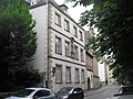
 Paderborn-Michaelskloster-2.JPG 3,648 × 2,736; 3.49 MB
-
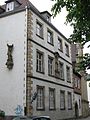
 Paderborn-Michaelskloster.jpg 3,648 × 2,736; 2.76 MB
-
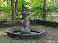 Paderborn-MichaelsklosterBrunnen1-Asio.jpg 2,133 × 1,596; 1.37 MB
-
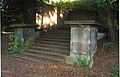 Paderborn-MichaelsklosterTreppenaufgang1-Asio.jpg 2,610 × 1,677; 1.51 MB

.jpg)
.jpg)
.jpg)


