Category:Mill Creek Mountain (West Virginia)
Jump to navigation
Jump to search
| Object location | | View all coordinates using: OpenStreetMap |
|---|
 | |||||
| Upload media | |||||
| Instance of | |||||
|---|---|---|---|---|---|
| Location | West Virginia | ||||
| Highest point |
| ||||
| Elevation above sea level |
| ||||
 | |||||
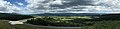
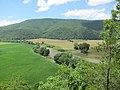
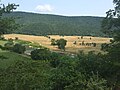
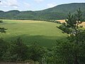
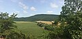
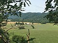
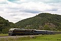
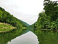
English: Mill Creek Mountain is a continuous mountain ridge that runs northeast through Hampshire and Hardy counties in the Potomac Highlands region of the U.S. state of West Virginia. Rising to its greatest elevation of 2,650 feet (808 m) at High Knob, Mill Creek is a folded mountain ridge, belonging to the Ridge-and-Valley Appalachians.
Subcategories
This category has the following 4 subcategories, out of 4 total.
Media in category "Mill Creek Mountain (West Virginia)"
The following 26 files are in this category, out of 26 total.
-

-
-
 Breakneck Romney WV 2013 07 14 03.jpg 3,648 × 2,736; 3.32 MB
-
 Breakneck Romney WV 2013 07 14 04.jpg 2,736 × 3,648; 3.78 MB
-
 Breakneck Romney WV 2013 07 14 06.jpg 3,648 × 2,736; 3.02 MB
-
 Breakneck Romney WV 2013 07 14 07.jpg 3,648 × 2,736; 3.29 MB
-
 Breakneck Romney WV 2014 07 29 01.jpg 2,048 × 1,536; 1.23 MB
-
 Breakneck Romney WV 2014 07 29 03.jpg 2,048 × 1,536; 1.19 MB
-
 Breakneck Romney WV 2014 07 29 05.jpg 2,048 × 1,536; 1.35 MB
-
 Breakneck Romney WV 2014 07 29 07.jpg 2,048 × 1,536; 1.27 MB
-
 Breakneck Romney WV 2014 07 29 09.jpg 3,882 × 1,536; 1.88 MB
-
 Breakneck Romney WV 2014 07 29 11.jpg 3,188 × 1,536; 2.02 MB
-
 Breakneck Romney WV 2014 07 29 13.jpg 2,048 × 1,536; 918 KB
-
 Breakneck Romney WV 2014 07 29 15.jpg 2,048 × 1,536; 916 KB
-
 Indian Mound Cemetery Romney WV 2010 04 25 13.JPG 3,072 × 2,304; 2.58 MB
-
 Indian Mound Cemetery Romney WV 2013 07 13 24.jpg 3,648 × 2,736; 3.36 MB
-
 Potomac Eagle - Hanging Rock (6170069291).jpg 5,184 × 3,456; 4.06 MB
-
 Potomac Eagle - Southbound (6170070043).jpg 4,658 × 2,930; 3.95 MB
-
 South Branch Potomac River Romney WV 2008 06 22 01.jpg 3,264 × 2,448; 1.92 MB
-
 The Kuykendall Polygonal Barn.jpg 640 × 443; 119 KB
-
 The Trough South Branch Potomac River WV 2016 07 03 01.jpg 4,032 × 3,024; 5.09 MB
-
 The Trough South Branch Potomac River WV 2016 07 03 05.jpg 4,032 × 3,024; 4.75 MB
-
 The Trough South Branch Potomac River WV 2016 07 03 06.jpg 4,032 × 3,024; 4.81 MB
-
 The Trough South Branch Potomac River WV 2016 07 03 07.jpg 4,032 × 3,024; 6.06 MB
-
 The Trough South Branch Potomac River WV 2016 07 03 08.jpg 4,032 × 3,024; 6.48 MB
-
 Valley View Romney WV 2013 01.jpg 1,024 × 768; 329 KB
_near_Fish_Pond_Road_in_western_Hardy_County,_West_Virginia.jpg)


.jpg)
.jpg)


_near_Fish_Pond_Road_in_western_Hardy_County,_West_Virginia.jpg)