Category:Ministerie van Koloniën, Den Haag
Jump to navigation
Jump to search
| Object location | | View all coordinates using: OpenStreetMap |
|---|
building in The Hague, Netherlands  | |||||
| Upload media | |||||
| Instance of | |||||
|---|---|---|---|---|---|
| Location | The Hague, South Holland, Netherlands | ||||
| Street address |
| ||||
| Located on street |
| ||||
| Architect | |||||
| Owned by | |||||
| Heritage designation |
| ||||
| Inception |
| ||||
 | |||||
|
This is a category about rijksmonument number 17880
|
| Address |
|
Media in category "Ministerie van Koloniën, Den Haag"
The following 31 files are in this category, out of 31 total.
-
 Den Haag - Plein 1.JPG 3,648 × 2,736; 3.59 MB
-
 Exterieur - 's-Gravenhage - 20087374 - RCE.jpg 1,200 × 778; 198 KB
-
 Exterieur DAKLIJST, DETAIL - 's-Gravenhage - 20262265 - RCE.jpg 1,200 × 780; 139 KB
-
 Exterieur GEDEELTE VAN GEVEL - 's-Gravenhage - 20262259 - RCE.jpg 794 × 1,200; 153 KB
-
 Exterieur GEDEELTE VAN GEVEL - 's-Gravenhage - 20262260 - RCE.jpg 1,200 × 796; 141 KB
-
 Exterieur GEDEELTE VAN GEVEL - 's-Gravenhage - 20262266 - RCE.jpg 1,200 × 744; 149 KB
-
 Exterieur GEDEELTE VAN GEVEL - 's-Gravenhage - 20262267 - RCE.jpg 795 × 1,200; 141 KB
-
 Exterieur OVERZICHT - 's-Gravenhage - 20262258 - RCE.jpg 1,200 × 799; 213 KB
-
 Exterieur OVERZICHT VOORGEVEL - 's-Gravenhage - 20262261 - RCE.jpg 792 × 1,200; 237 KB
-
 Exterieur OVERZICHT VOORGEVEL - 's-Gravenhage - 20262262 - RCE.jpg 1,200 × 812; 210 KB
-
 Exterieur VENSTER - 's-Gravenhage - 20262263 - RCE.jpg 799 × 1,200; 146 KB
-
 Exterieur VENSTER - 's-Gravenhage - 20262264 - RCE.jpg 781 × 1,200; 139 KB
-
 Exterieur VENSTER - 's-Gravenhage - 20262268 - RCE.jpg 1,200 × 763; 129 KB
-
 Exterieur VOORGEVEL - 's-Gravenhage - 20310428 - RCE.jpg 1,200 × 949; 289 KB
-
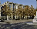
 Gebouwen aan plein - 's-Gravenhage - 20326814 - RCE.jpg 1,200 × 865; 159 KB
-
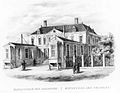 Het Ministerie van Koloniën aan het Plein in 1844.jpg 756 × 584; 71 KB
-
 Hoek Korte Vijverberg - 's-Gravenhage - 20089697 - RCE.jpg 3,150 × 2,322; 1.06 MB
-
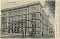
 Ministerie van Kolonien - 's-Gravenhage - 20380316 - RCE.jpg 1,200 × 1,182; 240 KB
-
 Ministerie van Kolonien - Den Haag - 20390065 - RCE.jpg 1,200 × 956; 317 KB
-

-
 Overzicht - 's-Gravenhage - 20089707 - RCE.jpg 1,200 × 813; 264 KB
-
 Overzicht - 's-Gravenhage - 20089708 - RCE.jpg 1,200 × 802; 211 KB
-
 Overzicht - 's-Gravenhage - 20089713 - RCE.jpg 1,200 × 798; 205 KB
-
 Overzicht west zijgevel - 's-Gravenhage - 20089715 - RCE.jpg 961 × 1,200; 218 KB
-
 Plein, met het standbeeld van prins Willem I en het ministerie van Koloniën.jpg 3,815 × 2,438; 962 KB
-
 Plein, ministerie van Koloniën in 1904.jpg 4,400 × 2,851; 1.5 MB
-
 Plein, standbeeld van Willem de Zwijger en Ministerie van Koloniën in aanbouw).jpg 1,808 × 2,056; 461 KB
-

-
 Regentenkamer tijdens PvdA Ledendag (9066521696).jpg 1,392 × 928; 426 KB
-
 Venster in oost zijgevel - 's-Gravenhage - 20089718 - RCE.jpg 967 × 1,200; 273 KB
-
 West zijgevel na de restauratie - 's-Gravenhage - 20089716 - RCE.jpg 961 × 1,200; 227 KB


.jpg)
_in_de_Regentenkamer_van_het_voormalig_Ministerie_van_Koloni%C3%ABn.jpg)
.jpg)

