Category:Molen van de Kerkepolder
Jump to navigation
Jump to search
| Object location | | View all coordinates using: OpenStreetMap |
|---|
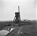
windmill in Wognum, Netherlands  | |||||
| Upload media | |||||
| Instance of | |||||
|---|---|---|---|---|---|
| Location | Wognum, Medemblik, North Holland, Netherlands | ||||
| Street address |
| ||||
| Has use |
| ||||
| Heritage designation |
| ||||
| Source of energy | |||||
 | |||||
|
This is a category about rijksmonument number 39318
|
| Address |
|
Media in category "Molen van de Kerkepolder"
The following 5 files are in this category, out of 5 total.
-
 Molen van kerkepolder - WLM 2011 - LindsayBruijn.jpg 683 × 1,024; 293 KB
-
 Oost-zijde van Oude Gouw - Wognum - 20216599 - RCE.jpg 792 × 1,200; 205 KB
-
 Watermolen van de Kerkpolder - Wognum - 20216591 - RCE.jpg 1,200 × 1,173; 191 KB
-
 Watermolen van de Kerkpolder - Wognum - 20216592 - RCE.jpg 1,200 × 1,170; 181 KB
-
 Wognum - molen van de Kerkepolder bij avond.jpg 1,300 × 1,950; 1.13 MB


