Category:Montague Island Light
Jump to navigation
Jump to search
| Object location | | View all coordinates using: OpenStreetMap |
|---|
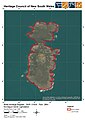
English: Montague Island Light is a heritage-listed lighthouse on Montague Island, New South Wales, Australia
lighthouse in New South Wales, Australia   | |||||
| Upload media | |||||
| Instance of |
| ||||
|---|---|---|---|---|---|
| Location | Narooma, Eurobodalla Shire, New South Wales, AUS | ||||
| Architect | |||||
| Heritage designation |
| ||||
| Area |
| ||||
 | |||||
Media in category "Montague Island Light"
The following 26 files are in this category, out of 26 total.
-
 1000 - Montague Island Lightstation - SHR Plan No 2954 (5014097b100).jpg 707 × 1,000; 199 KB
-
 Keepers quarters and lighthouse, Montague Island.jpg 600 × 401; 37 KB
-
 Lighthouse, Montague Island.jpg 435 × 600; 50 KB
-
 Montague Island 1917.jpg 425 × 315; 41 KB
-
 Montague Island and lighthouse from the west.jpg 1,200 × 900; 121 KB
-
 Montague Island banner.JPG 2,100 × 301; 173 KB
-
 Montague Island Light 1.jpg 432 × 600; 28 KB
-
 Montague Island Lighthouse and staff 2.jpg 438 × 600; 40 KB
-
 Montague Island Lighthouse and staff.jpg 430 × 600; 43 KB
-
 Montague island Lighthouse keepers cottage.JPG 2,560 × 1,920; 1.71 MB
-
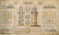 Montague Island lighthouse plans.jpg 705 × 425; 62 KB
-
 Montague Island Lighthouse, details of casements of gun metal, 1879.jpg 1,626 × 2,362; 301 KB
-

-
 Montague Island Lighthouse, particulars of wrought iron floor, 1879.jpg 2,362 × 1,616; 193 KB
-
 Montague Island, 1902.jpg 1,400 × 1,204; 296 KB
-
 Montague Island, ca 1900.jpg 600 × 454; 56 KB
-
 Montague Island, plan showing position of lighthouse quarters etc, 1888.jpg 2,362 × 1,466; 351 KB
-
 Montague Island.jpg 600 × 376; 45 KB
-
 Montague Lighthouse 1881.jpg 3,288 × 2,110; 1.85 MB
-
 MontagueIslandFmNarooma.jpg 2,048 × 1,536; 615 KB
-
 P1040310 LivingRoom.JPG 2,560 × 1,920; 1.88 MB
-
 Phare de l'ile Montague.jpg 2,048 × 1,365; 201 KB
-
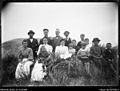 Residents and staff of Montague Island with W. H. Corkhill.jpg 600 × 456; 58 KB
-
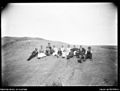 Residents and staff of Montague Island.jpg 600 × 455; 46 KB
-
 Staff and their families of Montague Island Lighthouse.jpg 600 × 453; 54 KB
-
 Western side of Montague Island and lighthouse.jpg 800 × 587; 107 KB
.jpg)


Categories:
- Lighthouses in New South Wales
- Lighthouses built by James Barnet
- Lighthouses built in 1881
- Lighthouses by height, 21 to 30 meters
- Lighthouses in Australia by name
- Built in Australia in 1881
- Montague Island (Australia)
- Commonwealth Heritage List
- New South Wales State Heritage Register
- Lighthouses with first order Fresnel lenses