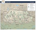
Category:Mountains of Bhutan
Vai alla navigazione
Vai alla ricerca
Paesi d’Asia: Afghanistan · Arabia Saudita · Armenia‡ · Azerbaigian‡ · Bangladesh · Bhutan · Birmania · Brunei · Cambogia · Cina · Cipro‡ · Corea del Nord · Corea del Sud · Egitto‡ · Emirati Arabi Uniti · Filippine · Georgia‡ · Giappone · Giordania · India · Indonesia‡ · Iran · Iraq · Israele · Kazakistan‡ · Kirghizistan · Laos · Libano · Malaysia · Mongolia · Nepal · Oman · Pakistan · Russia‡ · Siria · Sri Lanka · Tagikistan · Thailandia · Timor Est · Turchia‡ · Turkmenistan · Uzbekistan · Vietnam · Yemen
Riconoscimento limitato: Abcasia‡ · Cipro del Nord‡ · Palestina · Taiwan – Altri territori: Hong Kong
‡: in parte situato in Asia
Riconoscimento limitato: Abcasia‡ · Cipro del Nord‡ · Palestina · Taiwan – Altri territori: Hong Kong
‡: in parte situato in Asia
lista di un progetto Wikimedia | |||||
| Carica un file multimediale | |||||
| Istanza di | |||||
|---|---|---|---|---|---|
| |||||
Sottocategorie
Questa categoria contiene le 9 sottocategorie indicate di seguito, su un totale di 9.
*
- Peaks in Bhutan (1 F)
B
- Black Mountain, Bhutan (1 F)
G
- Gangkhar Puensum (8 F)
J
- Jomolhari (27 F)
K
- Khungdugang (1 F)
- Kula Kangri (7 F)
L
- Liankang Kangri (2 F)
File nella categoria "Mountains of Bhutan"
Questa categoria contiene 63 file, indicati di seguito, su un totale di 63.
-
 1003 Bhutan - Flickr - babasteve.jpg 1 080 × 720; 802 KB
-
 1016 Bhutan - Flickr - babasteve.jpg 1 080 × 720; 676 KB
-
 André Brugiroux TREK au Bouthan.png 397 × 655; 227 KB
-
 Bergsicht in Bhutan.jpg 1 280 × 960; 282 KB
-
 Bhutan Physiography.jpg 2 632 × 2 215; 948 KB
-
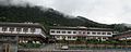 Buildings of Gaeddu College of Business Studies in Bhutan 2.jpg 4 608 × 1 855; 2,19 MB
-
 Buildings of Gaeddu College of Business Studies in Bhutan 3.jpg 4 608 × 3 456; 3,91 MB
-
 Buildings of Gaeddu College of Business Studies in Bhutan 4.jpg 4 608 × 2 114; 2,23 MB
-
 Buildings of Gaeddu College of Business Studies in Bhutan.jpg 4 608 × 3 456; 3,62 MB
-
 Chomolhari from Chelela.jpg 1 280 × 957; 938 KB
-
 Cloud covering green mountain in Bhutan 10.jpg 4 608 × 3 456; 3,47 MB
-
 Cloud covering green mountain in Bhutan 11.jpg 4 608 × 3 456; 2,87 MB
-
 Cloud covering green mountain in Bhutan 12.jpg 4 608 × 3 456; 4,49 MB
-
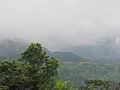 Cloud covering green mountain in Bhutan 13.jpg 4 608 × 3 456; 4,24 MB
-
 Cloud covering green mountain in Bhutan 14.jpg 4 608 × 3 456; 3,94 MB
-
 Cloud covering green mountain in Bhutan 15.jpg 4 608 × 3 456; 4,54 MB
-
 Cloud covering green mountain in Bhutan 16.jpg 4 608 × 3 456; 3,83 MB
-
 Cloud covering green mountain in Bhutan 17.jpg 4 608 × 3 456; 3,37 MB
-
 Cloud covering green mountain in Bhutan 2.jpg 4 608 × 3 456; 3,63 MB
-
 Cloud covering green mountain in Bhutan 3.jpg 4 608 × 3 456; 4,47 MB
-
 Cloud covering green mountain in Bhutan 4.jpg 4 608 × 3 456; 5,38 MB
-
 Cloud covering green mountain in Bhutan 5.jpg 4 608 × 3 456; 4,66 MB
-
 Cloud covering green mountain in Bhutan 6.jpg 4 608 × 3 456; 4,49 MB
-
 Cloud covering green mountain in Bhutan 7.jpg 4 608 × 3 456; 4,88 MB
-
 Cloud covering green mountain in Bhutan 8.jpg 4 608 × 3 456; 3,47 MB
-
 Cloud covering green mountain in Bhutan 9.jpg 4 608 × 3 456; 3,34 MB
-
 Cloud covering green mountain in Bhutan.jpg 4 608 × 3 456; 3,03 MB
-
 Cloud covering mountain in Bhutan 2.jpg 4 608 × 3 456; 3,04 MB
-
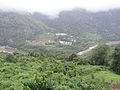
 Densely forested mountains of Jigme Dorji NP AJTJ IMG 1394.jpg 2 816 × 2 112; 3,59 MB
-
 Himalayan Landscape.jpg 1 253 × 940; 170 KB
-
 Himalayan mountain Valleys in Bhutan .jpg 6 000 × 3 369; 13,52 MB
-
 Jigme Dorji National Park, Bhutan.JPG 5 328 × 1 613; 1,66 MB
-
 Jitchu Drake.jpg 2 562 × 1 538; 924 KB
-
 Landscape of the mountains in Bhutan.jpg 8 000 × 6 000; 21,56 MB
-
 MAHAKAL PARVAT 21219.jpg 1 600 × 1 200; 357 KB
-
 Miri Punsum hills Haa Bhutan.jpg 4 928 × 3 264; 7,39 MB
-
 Mount Everest location in Himalaya map-Ar.png 2 000 × 1 151; 3,91 MB
-
 Mount Everest location in Himalaya map-fr.svg 1 190 × 685; 1,33 MB
-
 Mount Everest location in Himalaya map-hu.svg 1 190 × 685; 1,31 MB
-
 Mount Everest location in Himalaya map-mk.svg 1 190 × 685; 1,35 MB
-
 Mount Everest location in Himalaya map-ru.svg 1 190 × 685; 1,31 MB
-
 Mount Jomolhari 2009-10-11 a.jpg 2 592 × 3 456; 1,37 MB
-
 Mount Jomolhari from flight.jpg 518 × 345; 54 KB
-
 Mountain in Thimphu city, July 2016 01.jpg 4 608 × 3 456; 5,65 MB
-
 Mountain in Thimphu city, July 2016 02.jpg 4 608 × 3 456; 4,38 MB
-
 Mountain in Thimphu city, July 2016 03.jpg 4 608 × 3 456; 3,28 MB
-
 Mountain in Thimphu city, July 2016 04.jpg 4 608 × 3 456; 3,82 MB
-
 Mountain in Thimphu city, July 2016 05.jpg 4 608 × 3 456; 3,06 MB
-
 Mountain in Thimphu city, July 2016 06.jpg 4 608 × 3 456; 4,54 MB
-
 Mountain in Thimphu city, July 2016 07.jpg 2 048 × 1 536; 1,04 MB
-
 Mountains-2805167 640 - banner.jpg 5 472 × 782; 979 KB
-
 Mountains-2805167 640.jpg 5 472 × 3 648; 3,94 MB
-
 Natual beauty of rural Bhutan.jpg 4 608 × 3 456; 5,1 MB
-
 Paro - Auf Wanderung zum Taktsang-Kloster, Himalajakette.JPG 5 472 × 3 080; 2,81 MB
-
 Paro - Taktsang Kloster 3070 m.ü.NN. 02.JPG 5 472 × 3 080; 4,19 MB
-
 PeleLaView.jpg 5 312 × 1 520; 938 KB
-
 Phuentsoling city from high mountain.jpg 3 264 × 2 448; 2,64 MB
-
 Satellite image of Bhutan in April 2002.jpg 1 344 × 730; 202 KB
-
 The vast paddy of Nabji and Korphu.jpg 3 039 × 2 014; 1,15 MB
-
 Uratal.JPG 5 472 × 3 080; 5,03 MB
-
 View of Gasa Dzong.JPG 2 239 × 1 260; 1,23 MB
-
 Wv Jigme Dorji National Park banner.JPG 4 327 × 619; 579 KB
-
 Zizi village in Phobjikha.jpg 2 048 × 1 536; 619 KB


