Category:Mumpferflue
Jump to navigation
Jump to search
mountain in the Jura in the canton of Aargau, Schweiz  | |||||
| Upload media | |||||
| Instance of | |||||
|---|---|---|---|---|---|
| Location |
| ||||
| Has part(s) |
| ||||
| Mountain range | |||||
| Elevation above sea level |
| ||||
 | |||||
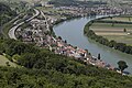
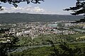
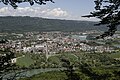
Deutsch: Die Mumpferflue ist ein 511 Meter hoher Hügel zwischen Mumpf, Stein und Obermumpf und fällt nördlich steil zum Rhein hin ab. Südöstlich geht er unmittelbar in ein Hochplateau über des Tafeljuras über. Auf der Mumpferfluh befindet sich auch die archäologischen Überreste einer befestigten Siedlungsstelle mit Abschnittsgräben (Unter kantonalem Schutz KGS-Nr.: 15647).
Subcategories
This category has only the following subcategory.
A
- Artilleriebunker A2631 Obermumpf (12 F)
Media in category "Mumpferflue"
The following 44 files are in this category, out of 44 total.
-
 Aussichtsturm Mumpferflue auf einer kolorierten Postkarte von 1905.jpg 2,271 × 1,419; 1.25 MB
-
 Aussichtsturm Mumpferflue, eingezeichnet auf einer Postkarte von 1905.jpg 2,830 × 1,796; 2.81 MB
-
 Aussichtsturm Mumpferflue, gezeichnet nach den Angaben im Staatsarchiv Aargau.jpg 1,671 × 2,843; 1.42 MB
-
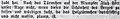
 Bericht in der „Volksstimme aus dem Frickthal“ vom 18. August 1909.jpg 3,030 × 888; 1.33 MB
-
 Inserat zur Turmeröffnung in der „Volksstimme aus dem Frickthal“ vom 15. Juli 1905.jpg 1,560 × 1,416; 908 KB
-
 Mumpf A3 Mumpferflue P6A0412.jpg 5,760 × 3,840; 6.83 MB
-
 Mumpf A3 Mumpferflue P6A0413.jpg 5,760 × 3,840; 6.99 MB
-
 Mumpf A3 Mumpferflue P6A0414.jpg 5,760 × 3,840; 7.14 MB
-
 Mumpferflue Graben P6A9772.jpg 3,840 × 5,760; 9.52 MB
-
 Mumpferflue Graben P6A9775.jpg 3,840 × 5,760; 9.98 MB
-
 Mumpferflue Graben P6A9779.jpg 3,840 × 5,760; 9.56 MB
-
 Mumpferflue Grabenbrücke P6A9769.jpg 5,760 × 3,840; 9.94 MB
-
 Mumpferflue Grabenbrücke P6A9770.jpg 3,840 × 5,760; 6.84 MB
-
 Mumpferflue Grabenbrücke P6A9771.jpg 3,840 × 5,760; 7.07 MB
-
 Mumpferflue Grabenbrücke P6A9774.jpg 5,760 × 3,840; 4.24 MB
-
 Mumpferflue Grabenbrücke P6A9776.jpg 5,760 × 3,840; 8.38 MB
-
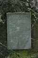
 Obermumpf Mumpferflue Gedenkstein P6A9781.jpg 3,840 × 5,760; 8.1 MB
-
 Obermumpf Mumpferflue Gedenkstein P6A9783.jpg 3,840 × 5,760; 6.28 MB
-
 Obermumpf Mumpferflue Gedenkstein P6A9784.jpg 3,840 × 5,760; 7.92 MB
-
 Obermumpf Mumpferflue P6A9723.jpg 5,760 × 3,840; 7.89 MB
-
 Obermumpf Mumpferflue P6A9731.jpg 5,760 × 3,840; 8.59 MB
-
 Obermumpf Mumpferflue P6A9732.jpg 5,760 × 3,840; 8.96 MB
-
 Obermumpf Mumpferflue P6A9736.jpg 5,760 × 3,840; 8.87 MB
-
 Obermumpf Mumpferflue P6A9738.jpg 5,760 × 3,840; 5.38 MB
-
 Obermumpf Mumpferflue P6A9740.jpg 5,760 × 3,840; 6.55 MB
-
 Obermumpf Mumpferflue P6A9741.jpg 5,760 × 3,840; 6.45 MB
-
 Obermumpf Mumpferflue P6A9744.jpg 5,760 × 3,840; 7.74 MB
-
 Obermumpf Mumpferflue P6A9745.jpg 5,760 × 3,840; 10.26 MB
-
 Obermumpf Mumpferflue P6A9748.jpg 5,760 × 3,840; 7.02 MB
-
 Obermumpf Mumpferflue P6A9749.jpg 5,760 × 3,840; 6.96 MB
-
 Obermumpf Mumpferflue P6A9786.jpg 5,760 × 3,840; 8.06 MB
-
 Obermumpf Mumpferflue P6A9787.jpg 5,760 × 3,840; 7.92 MB
-
 Obermumpf Mumpferflue P6A9788.jpg 5,760 × 3,840; 7.92 MB
-
 Obermumpf Mumpferflue P6A9789.jpg 5,760 × 3,840; 7.94 MB
-
 Obermumpf Mumpferflue P6A9790.jpg 5,760 × 3,840; 6.76 MB
-
 Obermumpf Mumpferflue P6A9791.jpg 5,760 × 3,840; 7.04 MB
-
 Obermumpf Mumpferflue P6A9793.jpg 5,760 × 3,840; 6.31 MB
-
 Obermumpf Mumpferflue P6A9796.jpg 5,760 × 3,840; 7.9 MB
-
 Obermumpf Mumpferflue P6A9797.jpg 5,760 × 3,840; 9.22 MB
-
 Obermumpf Mumpferflue P6A9799.jpg 5,760 × 3,840; 8.09 MB
-
 Obermumpf Mumpferflue P6A9801.jpg 5,760 × 3,840; 8.9 MB
-
 Obermumpf Mumpferflue P6A9802.jpg 5,760 × 3,840; 8.25 MB
-
 Obermumpf Mumpferflue Wegweiser P6A9792.jpg 5,760 × 3,840; 4.99 MB
-
 Textauszug aus dem Aufsatz „Die Mumpfer Fluh“ von Wilhelm Schuster.jpg 905 × 141; 104 KB


