Category:Mývatn
Jump to navigation
Jump to search
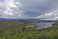
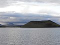
English: This category contains pictures of Lake Myvatn in northeastern Iceland.
Deutsch: Diese Kategorie enthält Bilder der Umgebung des Sees Myvatn in Nordostisland.

lake  | |||||
| Upload media | |||||
| Instance of | |||||
|---|---|---|---|---|---|
| Located in protected area |
| ||||
| Location | |||||
| Heritage designation | |||||
| Area |
| ||||
| Elevation above sea level |
| ||||
| Outflows | |||||
| Basin country | |||||
 | |||||
Subcategories
This category has the following 32 subcategories, out of 32 total.
*
- Landscapes of Mývatn (61 F)
+
B
- Brettingsstaðir (Laxárdal) (5 F)
D
F
G
H
J
- Jarðböðin við Mývatn (1 P, 38 F)
K
- Kráká (1 F)
M
N
R
S
- Shores of Lake Mývatn (11 F)
V
Pages in category "Mývatn"
The following 6 pages are in this category, out of 6 total.
Media in category "Mývatn"
The following 128 files are in this category, out of 128 total.
-
Mývatn pronunciation.ogg 2.3 s; 146 KB
-
 06-5-13 Parkplatz Hotel Reynihlíd, Hverfjall li. im Hintergrund.jpg 1,544 × 1,024; 772 KB
-
 06-5-14 Fischtrockengestell am Mývatn in Reynihlid, Vindbegur im Hintergrund.jpg 1,544 × 1,024; 786 KB
-
 2008-05-19 11-39-36 Iceland Norðurland Eystra Reykjahlíð.jpg 2,027 × 1,519; 2.12 MB
-
 2008-05-19 11-40-56 Iceland Norðurland Eystra Reykjahlíð.jpg 2,009 × 1,507; 2.15 MB
-
 2008-05-19 11-47-09 Iceland Norðurland Eystra Reykjahlíð.jpg 2,009 × 1,507; 2.61 MB
-
 2008-05-19 19 At Grjótagiá.jpg 6,738 × 1,263; 2.99 MB
-
 2008-05-19 19-27-06 Iceland Norðurland Eystra Reykjahlíð.jpg 2,009 × 1,507; 2.13 MB
-
 2008-05-21 10 360° Top of Námafjall.jpg 23,953 × 1,395; 7.82 MB
-
 2008-05-21 10 42 56 Iceland-Reykjahlíð.jpg 2,048 × 1,536; 2.51 MB
-
 2008-05-21 12 39 34 Iceland-Skútustaðir.jpg 2,009 × 1,507; 2.37 MB
-
 2008-05-21 12 40 31 Iceland-Skútustaðir.jpg 2,015 × 1,511; 2.45 MB
-
 2008-05-21 12 48 23 Iceland-Skútustaðir.jpg 2,048 × 1,536; 2.5 MB
-
 2008-05-21 13 00 06 Iceland-Skútustaðir.jpg 2,048 × 1,536; 2.19 MB
-
 2008-05-21 13 05 27 Iceland-Skútustaðir.jpg 2,048 × 1,536; 2.35 MB
-
 2008-05-21 13 12 01 Iceland-Skútustaðir.jpg 2,009 × 1,507; 2.23 MB
-
 2008-05-21 13 16 18 Iceland-Skútustaðir.jpg 2,048 × 1,536; 2.5 MB
-
 2008-05-21 13 24 00 Iceland-Skútustaðir.jpg 2,048 × 1,536; 2.55 MB
-
 2008-05-21 14 17 28 Iceland-Skútustaðir.jpg 2,021 × 1,515; 2.53 MB
-
 2014-04-28 17-48-09 Iceland - Mývatni Reykjahlíð.JPG 4,137 × 2,747; 4.73 MB
-
 2014-05-03 13-40-16 Iceland - Mývatni Reykjahlíð 10h 360°.JPG 20,785 × 2,534; 31.77 MB
-
 A view to the lake Mývatn, Iceland 03.jpg 6,000 × 3,362; 10.4 MB
-
 Aerial View of Reykjalið 21.05.2008 16-04-03.JPG 2,048 × 1,064; 711 KB
-
 Bjarnarflag 03.JPG 2,592 × 1,944; 849 KB
-
 Blue Lagoon of Mývatn - 2013.08 - panoramio (1).jpg 4,608 × 3,456; 3.23 MB
-
 Bottom of Mývatn.jpg 2,113 × 1,000; 515 KB
-
 Church near Mývatn. (4558256825).jpg 1,149 × 1,536; 220 KB
-
 Ciel bleu (5018532907).jpg 5,184 × 3,456; 4.87 MB
-
 Colonnes du lac (5018531307).jpg 5,184 × 3,456; 6 MB
-
 Cygnus cygnus-pjt.jpg 2,651 × 1,491; 1.87 MB
-
 Dimmuborgir (3795448793).jpg 4,272 × 2,840; 4.59 MB
-
 Dimmuborgir (3796265992).jpg 4,188 × 2,784; 3.39 MB
-
 Ein Scheinkrater im Mývatn 6087-6088.JPG 6,049 × 2,420; 4.79 MB
-
 Ein Scheinkrater im Mývatn 6088.JPG 3,804 × 2,536; 5.43 MB
-
 Eistaucher (Gavia immer), Prachtkleid.jpg 2,100 × 1,400; 1.48 MB
-
 Eistaucher (Gavia immer).jpg 2,100 × 1,400; 1.62 MB
-
 FieldOfRocksInAkureyri.jpg 1,600 × 1,200; 1.51 MB
-
 Floden in mot Myvatn (14341894069).jpg 1,200 × 900; 562 KB
-
 Goldregenpfeifer Männchen Mývatn 2020.jpg 3,638 × 2,717; 2.16 MB
-
 Hembra de phalaropus lobatus.jpg 800 × 533; 374 KB
-
 Hill (Mývatn).JPG 640 × 480; 72 KB
-
 Hverarönð 2 - panoramio.jpg 4,320 × 3,240; 5.17 MB
-
 Hverfell-Crater.JPG 640 × 480; 74 KB
-
 Hverfell-drone-shot.jpg 5,464 × 3,640; 5.02 MB
-
 Hverfell4Vulcanos.jpg 2,978 × 1,962; 880 KB
-
 Hverfjall Crater & Mývatn Lake - panoramio.jpg 2,285 × 1,523; 833 KB
-
 Höfði03(js).jpg 1,535 × 1,024; 756 KB
-
 Iceland (19829491238).jpg 3,264 × 2,448; 2.37 MB
-
 Iceland in August 2002 09.jpg 2,560 × 1,920; 614 KB
-
 Iceland Lake Mývatn Myvatn.JPG 2,272 × 1,704; 1.35 MB
-
 Iceland Myvatn.JPG 1,540 × 1,025; 357 KB
-
 Island Myvatn Pseudokrater.JPG 2,272 × 1,704; 1.47 MB
-
 Islande - Le lac Mivatn.JPG 2,048 × 1,536; 651 KB
-
 Islande5.jpg 3,556 × 2,580; 2.01 MB
-
 Lake Myvatn - Iceland - panoramio (1).jpg 3,648 × 2,736; 4.62 MB
-
 Lake Myvatn - Iceland - panoramio.jpg 3,648 × 2,736; 4.74 MB
-
 Lake Mývatn - 2013.08 - panoramio.jpg 4,544 × 3,408; 3.24 MB
-
 Lake Mývatn, Iceland (42650338134).jpg 11,643 × 3,184; 19.41 MB
-
 LC P8060115.JPG 2,048 × 1,536; 620 KB
-
 Leirhnjúkur 5992.JPG 3,795 × 2,530; 3.2 MB
-
 Like the Caribbean (14451857582).jpg 3,032 × 1,705; 1.26 MB
-
 Macho de phalaropus lobatus.jpg 800 × 533; 317 KB
-
 Myvatn (14342056507).jpg 1,368 × 772; 417 KB
-
 Myvatn (14342056527).jpg 1,247 × 772; 482 KB
-
 Myvatn (16575159700).jpg 4,320 × 3,240; 3.06 MB
-
 Myvatn (38321701152).jpg 6,699 × 3,768; 13.61 MB
-
 Myvatn - Dintorni.JPG 2,592 × 1,944; 874 KB
-
 Myvatn - Flickr - Stiller Beobachter.jpg 3,008 × 2,000; 2.05 MB
-
 Myvatn banner.jpg 2,100 × 300; 642 KB
-
 Myvatn Blájfall 01 HDR (1417090645).jpg 2,048 × 1,495; 758 KB
-
 Myvatn Iceland 01.jpg 3,008 × 2,008; 2.91 MB
-
 Myvatn lake looking to South - panoramio.jpg 3,072 × 933; 1.25 MB
-
 Myvatn lake.jpg 1,660 × 441; 83 KB
-
 Myvatn midges 01 (1417092261).jpg 2,048 × 1,412; 723 KB
-
 Myvatn panorama 01.jpg 5,429 × 1,300; 1.58 MB
-
 Myvatn panorama.jpg 3,264 × 870; 1.18 MB
-
 Myvatn0207 - Flickr - Ragnhild & Neil Crawford.jpg 3,456 × 2,304; 5.92 MB
-
 Myvatn0208 - Flickr - Ragnhild & Neil Crawford.jpg 3,456 × 2,304; 5.93 MB
-
 Myvatn0209 - Flickr - Ragnhild & Neil Crawford.jpg 3,456 × 2,304; 5.6 MB
-
 Myvatn0210 - Flickr - Ragnhild & Neil Crawford.jpg 3,456 × 2,304; 5.66 MB
-
 Myvatn1989.jpg 753 × 500; 175 KB
-
 Myvatn2.jpg 1,280 × 960; 523 KB
-
 Myvatn3.jpg 960 × 1,280; 863 KB
-
 MyvatnPseudocraters-pjt.jpg 7,953 × 2,030; 7.4 MB
-
 Mývatn (6802982523).jpg 4,272 × 2,848; 3.11 MB
-
 Mývatn Lake.jpg 1,600 × 1,066; 91 KB
-
 Mývatn near Skútustaðir.jpg 3,127 × 1,089; 674 KB
-
 Mývatn Volcano Panorama (182802967).jpeg 2,048 × 1,365; 545 KB
-
 Mývatn, edged with pseudocraters.jpg 2,794 × 1,000; 771 KB
-
 Mývatn, looking northeast.jpg 2,289 × 1,500; 563 KB
-
 Mývatn, looking west from Höfði II.jpg 1,307 × 700; 213 KB
-
 Mývatn, looking west from Höfði.jpg 2,610 × 1,500; 711 KB
-
 Mývatn-pjt.jpg 5,828 × 2,035; 5.14 MB
-
 Mývatn. (4558304573).jpg 1,536 × 1,153; 237 KB
-
 Mývatn. - Duck's eggs and nest. (4558860996).jpg 1,536 × 1,095; 589 KB
-
 Mývatnssveit (3795411865).jpg 4,272 × 2,840; 4.23 MB
-
 Mývatnssveit (3795416663).jpg 2,840 × 4,272; 6.47 MB
-
 Mývatnssveit (3795418237).jpg 4,272 × 2,840; 3.91 MB
-
 Mývatnssveit (3795420057).jpg 4,272 × 2,840; 4.62 MB
-
 Mývatnssveit (3796232696).jpg 1,974 × 1,318; 972 KB
-
 Mývatnssveit (3796241088).jpg 4,272 × 2,840; 5.45 MB
-
 Mývatnssveit (3796243378).jpg 2,840 × 4,272; 5.27 MB
-
 Mývatnssveit (3796245104).jpg 4,272 × 2,840; 4.09 MB
-
 Mývatnssveit (3796246496).jpg 4,212 × 2,800; 3.45 MB
-
 Mývatnssveit (3796248646).jpg 4,272 × 2,840; 5.62 MB
-
 Mývatnssveit (3796249784).jpg 4,174 × 2,774; 2.91 MB
-
 Mývatnssveit (4674553127).jpg 2,136 × 1,420; 621 KB
-
 Near Skútustaðahreppur (14789095742).jpg 2,560 × 1,441; 641 KB
-
 Nordiska taflor - no-nb digibok 2014031426011-16.jpg 4,203 × 3,270; 2.84 MB
-
 North Iceland Mývatn (general view).jpg 2,242 × 1,648; 1.93 MB
-
 Northeastern Region, Iceland - panoramio (42).jpg 3,888 × 2,592; 991 KB
-
 Oktober2017Island 091.jpg 2,200 × 1,320; 491 KB
-
 Oktober2017Island 094.jpg 2,200 × 1,320; 511 KB
-
 Panorama of Mývatn - 2013.08 - panoramio.jpg 3,582 × 2,015; 2.31 MB
-
 Phalaropus lobatus copula-pjt.jpg 877 × 1,772; 1.25 MB
-
 Pseudocraters - Lake Myvatn - Iceland - panoramio.jpg 3,648 × 2,736; 4.44 MB
-
 Skútustaðir (52420426971).jpg 1,024 × 768; 202 KB
-
 Skútustaðir01(js).jpg 3,009 × 1,390; 2.08 MB
-
 Skútustaðir02(js).jpg 3,873 × 2,149; 3.11 MB
-
 Solfatara.JPG 640 × 480; 76 KB
-
 South over Mývatn.jpg 1,213 × 700; 228 KB
-
 Southwest toward Mývatn from Krafla.jpg 1,864 × 1,000; 689 KB
-
 Stakhólstjörn - panoramio.jpg 3,648 × 2,432; 11.3 MB
-
 Vedmyvatn.png 519 × 373; 219 KB
-
 Vogar on the east shore of Mývatn.jpg 1,605 × 700; 242 KB
-
 Vue du Lac Myvatn depuis les Pseudo-cratères.jpg 3,264 × 2,448; 1.64 MB
-
 Waterfowls on Lake Mývatn - 2013.08 - panoramio.jpg 4,608 × 3,456; 3.11 MB
-
 Yellow North Iceland (51115538).jpeg 800 × 1,000; 366 KB


.jpg)

.jpg)
.jpg)
.jpg)

.jpg)
.jpg)

,_Prachtkleid.jpg)
.jpg)

.jpg)


.JPG)


.jpg)
.jpg)


.jpg)


.jpg)

.jpg)
.jpg)
.jpg)
.jpg)


.jpg)

.jpg)


.jpg)

.jpeg)


.jpg)
.jpg)
.jpg)
.jpg)
.jpg)
.jpg)
.jpg)
.jpg)
.jpg)
.jpg)
.jpg)
.jpg)
.jpg)
.jpg)
.jpg)

.jpg)
.jpg)


.jpg)
.jpg)
.jpg)


.jpeg)
.jpg)
Categories:
- Lakes of Iceland
- Skútustaðahreppur
- Highland of Norðurland eystra
- Norðurland eystra
- Krafla (volcanic system)
- Trout angling in Iceland
- Protected areas of Iceland
- Hringvegur (Norðurlandsvegur, North Iceland)
- Fishing lakes in Iceland
- Volcanic lakes
- Lava dammed lakes
- Visitor attractions in Iceland
- Bodies of water of the Krafla volcanic system
- Bodies of water of the Fremrinámur volcanic system
- Bodies of water of the Heiðarsporðar volcanic system
- Laxárhraun (older, Ketildyngja)
- Laxárhraun yngra (Younger Laxá Lava)
- Visitor attractions in Norðurland eystra
- Lakes of Norðurland eystra
- Geography of Norðurland eystra
- Game of Thrones filming locations and production sets
- Lava dammed lakes of Iceland
- Ramsar sites in Iceland