Category:NUTS maps of Bulgaria
‡: partly located in Europe
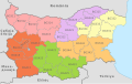
The Nomenclature of Territorial Units for Statistics, (NUTS, for the French nomenclature d'unités territoriales statistiques), is a geocode standard for referencing the spatial divisions of countries for statistical purposes. The NUTS divisions do not necessarily correspond to administrative divisions within the country.
A NUTS code begins with a two-letter code referencing the country, which is identical to the ISO 3166-1 alpha-2 code (except UK instead of GB for the United Kingdom). The subdivision of the country is then referred to with one number. A second or third subdivision level is referred to with another number each.
Each numbering starts with 1, as 0 is used for the upper level. In case the subdivision has more than 9 entities, capital letters are used to continue the numbering.
Media in category "NUTS maps of Bulgaria"
The following 5 files are in this category, out of 5 total.
-
 Bulgaria NUTS 1.svg 534 × 348; 198 KB
-
 NUTS BG Level 1 and 2.png 548 × 380; 35 KB
-
 NUTS BG.svg 1,642 × 1,036; 819 KB
-
 NUTS-2-Proposal-2017-BG.png 2,195 × 1,440; 763 KB
-
 NUTS-2-Proposal-2017-EN.png 2,195 × 1,440; 9.06 MB


