Category:Nederlands Hervormde Kerk, Est
Jump to navigation
Jump to search
| Object location | | View all coordinates using: OpenStreetMap |
|---|
church in Est, Netherlands  | |||||
| Upload media | |||||
| Instance of | |||||
|---|---|---|---|---|---|
| Location | Est, West Betuwe, Gelderland, Netherlands | ||||
| Street address |
| ||||
| Located on street |
| ||||
| Heritage designation |
| ||||
 | |||||
|
This is a category about rijksmonument number 30336
|
| Address |
|
Media in category "Nederlands Hervormde Kerk, Est"
The following 48 files are in this category, out of 48 total.
-
 Blaker aan preekstoel - Est - 20072417 - RCE.jpg 1,200 × 948; 250 KB
-
 Detail herenbank - Est - 20072429 - RCE.jpg 1,184 × 1,200; 377 KB
-
 Detail noordgevel - Est - 20072407 - RCE.jpg 955 × 1,200; 276 KB
-
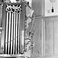
 Detail orgel - Est - 20072434 - RCE.jpg 1,200 × 1,195; 240 KB
-
 Detail orgel - Est - 20072435 - RCE.jpg 1,197 × 1,200; 275 KB
-
 Detail orgel - Est - 20072437 - RCE.jpg 1,200 × 1,200; 268 KB
-
 Detail orgel - Est - 20072438 - RCE.jpg 1,200 × 1,195; 304 KB
-
 Detail orgel - Est - 20072439 - RCE.jpg 1,186 × 1,200; 343 KB
-
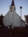
 Est NH Kerk.jpg 3,600 × 3,293; 4.28 MB
-
 Est-kerk.jpg 240 × 320; 12 KB
-
 Exterieur vanuit het westen - Est - 20072398 - RCE.jpg 872 × 1,200; 198 KB
-
 Gedeelte noordgevel - Est - 20072408 - RCE.jpg 952 × 1,200; 148 KB
-
 Gedeelte zuidgevel - Est - 20072405 - RCE.jpg 952 × 1,200; 216 KB
-
 Gedeelte zuidgevel - Est - 20072406 - RCE.jpg 1,200 × 948; 242 KB
-
 Grafmonument in consistoriekamer - Est - 20072424 - RCE.jpg 957 × 1,200; 198 KB
-
 Herenbank - Est - 20072428 - RCE.jpg 1,200 × 1,195; 265 KB
-
 Interieur consistoriekamer - Est - 20072422 - RCE.jpg 1,200 × 956; 166 KB
-
 Interieur consistoriekamer - Est - 20072423 - RCE.jpg 1,200 × 956; 199 KB
-
 Interieur naar de preekstoel - Est - 20072426 - RCE.jpg 1,197 × 1,200; 246 KB
-
 Interieur naar het oosten - Est - 20072410 - RCE.jpg 1,200 × 939; 161 KB
-
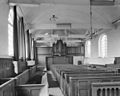
 Interieur naar het westen - Est - 20072411 - RCE.jpg 1,200 × 964; 201 KB
-
 Interieur naar het westen - Est - 20072412 - RCE.jpg 1,200 × 961; 181 KB
-
 Interieur, aanzicht orgel, orgelnummer 445 - Est - 20359394 - RCE.jpg 956 × 1,200; 164 KB
-
 Interieur, detail van de herenbank - Est - 20379722 - RCE.jpg 1,198 × 1,200; 231 KB
-
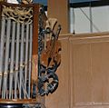 Interieur, instrumenten in het houtsnijwerk van het orgel - Est - 20379720 - RCE.jpg 1,200 × 1,193; 216 KB
-
 Interieur, overzicht van de herenbank - Est - 20379721 - RCE.jpg 1,200 × 1,189; 200 KB
-
 Interieur, overzicht van het orgel, orgelnummer 445 - Est - 20384957 - RCE.jpg 954 × 1,200; 157 KB
-
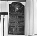
 Interieur, tekstbord - Est - 20379718 - RCE.jpg 1,200 × 1,191; 224 KB
-
 Interieur, tekstbord - Est - 20379719 - RCE.jpg 1,200 × 1,189; 253 KB
-
 Kaarsenarm van preekstoel - Est - 20072415 - RCE.jpg 1,200 × 974; 164 KB
-
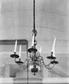 Kroon - Est - 20072421 - RCE.jpg 991 × 1,200; 132 KB
-
 Lezenaar van preekstoel - Est - 20072414 - RCE.jpg 1,022 × 1,200; 273 KB
-
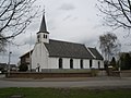 N-H kerk Est.jpg 3,264 × 2,448; 1.83 MB
-
 Oostgevel - Est - 20072409 - RCE.jpg 1,200 × 957; 206 KB
-
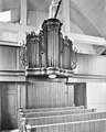 Orgel - Est - 20072418 - RCE.jpg 957 × 1,200; 201 KB
-
 Orgel - Est - 20072432 - RCE.jpg 1,198 × 1,200; 242 KB
-
 Orgel - Est - 20072433 - RCE.jpg 1,195 × 1,200; 270 KB
-
 Overzicht zuid-west gevel - Est - 20072404 - RCE.jpg 1,200 × 955; 209 KB
-
 Overzicht zuidgevel - Est - 20072403 - RCE.jpg 1,200 × 955; 199 KB
-
 Preekstoel - Est - 20072413 - RCE.jpg 1,200 × 950; 206 KB
-
 Preekstoel en doopvont - Est - 20072427 - RCE.jpg 1,190 × 1,200; 280 KB
-
 Tekstbord - Est - 20072430 - RCE.jpg 1,200 × 1,190; 290 KB
-
 Tekstbord - Est - 20072431 - RCE.jpg 1,200 × 1,190; 271 KB
-
 Tekstbord 1749 - Est - 20072419 - RCE.jpg 1,002 × 1,200; 204 KB
-
 Tekstbord 1749 - Est - 20072420 - RCE.jpg 995 × 1,200; 222 KB
-
 Wit marmeren grafmonument - Est - 20072401 - RCE.jpg 879 × 1,200; 188 KB
-
 Zandloperhouder van preekstoel - Est - 20072416 - RCE.jpg 1,200 × 959; 139 KB
-
 Zilveren avondmaalsbeker - Est - 20072402 - RCE.jpg 881 × 1,200; 147 KB


