Category:Nederlands Hervormde Kerk, Hendrik-Ido-Ambacht
Jump to navigation
Jump to search
| Object location | | View all coordinates using: OpenStreetMap |
|---|
church in Hendrik-Ido-Ambacht, Netherlands  | |||||
| Upload media | |||||
| Instance of | |||||
|---|---|---|---|---|---|
| Location | Hendrik-Ido-Ambacht, South Holland, Netherlands | ||||
| Street address |
| ||||
| Heritage designation |
| ||||
 | |||||
|
This is a category about rijksmonument number 21503
|
| Address |
|
Media in category "Nederlands Hervormde Kerk, Hendrik-Ido-Ambacht"
The following 95 files are in this category, out of 95 total.
-
 Binnenplaats - Hendrik-Ido-Ambacht - 20106229 - RCE.jpg 1,011 × 1,200; 244 KB
-
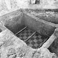
 Blootgelegde fundering - Hendrik-Ido-Ambacht - 20106267 - RCE.jpg 1,190 × 1,200; 408 KB
-
 Blootgelegde fundering - Hendrik-Ido-Ambacht - 20106268 - RCE.jpg 1,200 × 1,197; 409 KB
-
 Blootgelegde fundering - Hendrik-Ido-Ambacht - 20106269 - RCE.jpg 1,192 × 1,200; 403 KB
-
 Blootgelegde fundering - Hendrik-Ido-Ambacht - 20106270 - RCE.jpg 1,188 × 1,200; 366 KB
-
 Blootgelegde fundering - Hendrik-Ido-Ambacht - 20106272 - RCE.jpg 1,186 × 1,200; 426 KB
-
 Blootgelegde fundering - Hendrik-Ido-Ambacht - 20106273 - RCE.jpg 1,197 × 1,200; 355 KB
-
 Blootgelegde fundering - Hendrik-Ido-Ambacht - 20106274 - RCE.jpg 1,188 × 1,200; 403 KB
-
 Blootgelegde fundering en tegelvloer - Hendrik-Ido-Ambacht - 20106271 - RCE.jpg 1,200 × 1,200; 392 KB
-
 Dorpskerk (Hendrik Ido Ambacht).jpg 480 × 640; 44 KB
-
 Dubbel glas in loodraam - Hendrik-Ido-Ambacht - 20108505 - RCE.jpg 1,184 × 1,200; 442 KB
-
 Dubbel glas in loodramen - Hendrik-Ido-Ambacht - 20108506 - RCE.jpg 1,193 × 1,200; 437 KB
-
 Dubbel glas in loodramen - Hendrik-Ido-Ambacht - 20108507 - RCE.jpg 1,185 × 1,200; 226 KB
-
 Dubbel glas in loodramen - Hendrik-Ido-Ambacht - 20108508 - RCE.jpg 1,200 × 1,200; 200 KB
-
 Dubbel glas in loodramen - Hendrik-Ido-Ambacht - 20108509 - RCE.jpg 1,191 × 1,200; 194 KB
-
 Dubbel glas in loodramen - Hendrik-Ido-Ambacht - 20108510 - RCE.jpg 1,195 × 1,200; 180 KB
-
 Dubbel glas in loodramen - Hendrik-Ido-Ambacht - 20108511 - RCE.jpg 1,200 × 1,199; 212 KB
-
 Dubbel glas in loodramen - Hendrik-Ido-Ambacht - 20108512 - RCE.jpg 1,190 × 1,200; 361 KB
-

-

-
 Exterieur naar het noord-oosten - Hendrik-Ido-Ambacht - 20108462 - RCE.jpg 2,326 × 3,144; 1.87 MB
-
 Exterieur naar het noord-oosten - Hendrik-Ido-Ambacht - 20108474 - RCE.jpg 960 × 1,200; 181 KB
-
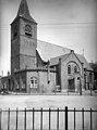
 Exterieur naar het oosten - Hendrik-Ido-Ambacht - 20108461 - RCE.jpg 869 × 1,200; 175 KB
-
 Exterieur naar het westen - Hendrik-Ido-Ambacht - 20108475 - RCE.jpg 961 × 1,200; 265 KB
-
 Exterieur naar het zuid-oosten - Hendrik-Ido-Ambacht - 20108463 - RCE.jpg 1,200 × 877; 186 KB
-
 Exterieur naar het zuid-westen - Hendrik-Ido-Ambacht - 20108464 - RCE.jpg 894 × 1,200; 243 KB
-
 Exterieur naar het zuid-westen - Hendrik-Ido-Ambacht - 20108465 - RCE.jpg 894 × 1,200; 233 KB
-
 Exterieur zuid-oost zijde - Hendrik-Ido-Ambacht - 20108476 - RCE.jpg 959 × 1,200; 264 KB
-
 Funderingen aan de noordzijde van de toren - Hendrik-Ido-Ambacht - 20106282 - RCE.jpg 1,197 × 1,200; 349 KB
-
 Funderingen aan de noordzijde van de toren - Hendrik-Ido-Ambacht - 20106283 - RCE.jpg 1,200 × 1,200; 396 KB
-
 Funderingen aan de noordzijde van de toren - Hendrik-Ido-Ambacht - 20106284 - RCE.jpg 1,197 × 1,200; 314 KB
-
 Funderingen aan de noordzijde van de toren - Hendrik-Ido-Ambacht - 20106285 - RCE.jpg 1,195 × 1,200; 411 KB
-

-
 Grafzerk Hendrik Van der Gyessen 1613 - Hendrik-Ido-Ambacht - 20108487 - RCE.jpg 1,183 × 1,200; 295 KB
-
 Grafzerk Leendert Besemer 1622 - Hendrik-Ido-Ambacht - 20108486 - RCE.jpg 1,188 × 1,200; 383 KB
-
 Grafzerk Leendert Jacobssoon Besemer 1611 - Hendrik-Ido-Ambacht - 20106259 - RCE.jpg 1,188 × 1,200; 395 KB
-
 Grafzerk Pleuntien Clasen van Noordt - Hendrik-Ido-Ambacht - 20108492 - RCE.jpg 1,192 × 1,200; 426 KB
-
 Herenbank - Hendrik-Ido-Ambacht - 20108503 - RCE.jpg 1,200 × 960; 145 KB
-

-
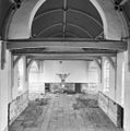
 Interieur - Hendrik-Ido-Ambacht - 20108466 - RCE.jpg 889 × 1,200; 160 KB
-
 Interieur - Hendrik-Ido-Ambacht - 20108483 - RCE.jpg 1,166 × 1,200; 190 KB
-
 Interieur grafzerk 1665 Velsenaer Dijkgraaf - Hendrik-Ido-Ambacht - 20108491 - RCE.jpg 1,185 × 1,200; 377 KB
-
 Interieur grafzerk Frank Wijten 1647 - Hendrik-Ido-Ambacht - 20108490 - RCE.jpg 1,186 × 1,200; 439 KB
-

-
 Interieur grafzerk Lodewijckx 23 april 1610 - Hendrik-Ido-Ambacht - 20106260 - RCE.jpg 1,190 × 1,200; 461 KB
-

-

-

-
-
 Interieur naar het noord-westen - Hendrik-Ido-Ambacht - 20108498 - RCE.jpg 1,200 × 960; 145 KB
-

-
 Interieur naar het oosten - Hendrik-Ido-Ambacht - 20108480 - RCE.jpg 958 × 1,200; 206 KB
-
 Interieur naar het oosten - Hendrik-Ido-Ambacht - 20108500 - RCE.jpg 1,200 × 951; 163 KB
-
 Interieur naar het oosten met orgel - Hendrik-Ido-Ambacht - 20108499 - RCE.jpg 960 × 1,200; 189 KB
-

-
 Interieur naar het westen - Hendrik-Ido-Ambacht - 20108468 - RCE.jpg 892 × 1,200; 159 KB
-
 Interieur naar het westen - Hendrik-Ido-Ambacht - 20108477 - RCE.jpg 955 × 1,200; 176 KB
-
 Interieur naar het zuid-oosten - Hendrik-Ido-Ambacht - 20108467 - RCE.jpg 895 × 1,200; 155 KB
-
 Interieur overzicht zerkenvloer - Hendrik-Ido-Ambacht - 20108485 - RCE.jpg 1,188 × 1,200; 326 KB
-

-
 Interieur, glas-in-loodraam - Hendrik-Ido-Ambacht - 20108471 - RCE.jpg 894 × 1,200; 155 KB
-
 Interieur, glas-in-loodraam - Hendrik-Ido-Ambacht - 20108472 - RCE.jpg 894 × 1,200; 144 KB
-
 Interieur, glas-in-loodraam - Hendrik-Ido-Ambacht - 20108473 - RCE.jpg 894 × 1,200; 145 KB
-
 Interieur, orgel - Hendrik-Ido-Ambacht - 20108501 - RCE.jpg 960 × 1,200; 168 KB
-

-
 INTERIEUR, OVERZICHT GLAS IN LOODRAAM - Hendrik-Ido-Ambacht - 20263110 - RCE.jpg 765 × 1,200; 150 KB
-

-
 INTERIEUR, OVERZICHT GLAS IN LOODRAAM - Hendrik-Ido-Ambacht - 20263113 - RCE.jpg 940 × 1,200; 124 KB
-
 Kansel - Hendrik-Ido-Ambacht - 20108481 - RCE.jpg 960 × 1,200; 190 KB
-
 Koor - Hendrik-Ido-Ambacht - 20108469 - RCE.jpg 899 × 1,200; 148 KB
-
 Nis in koorsluiting ( exterieur ) - Hendrik-Ido-Ambacht - 20108504 - RCE.jpg 1,197 × 1,200; 456 KB
-
 Noord-oost gevel - Hendrik-Ido-Ambacht - 20108494 - RCE.jpg 1,200 × 950; 270 KB
-
 Noordgevel - Hendrik-Ido-Ambacht - 20108493 - RCE.jpg 1,200 × 943; 261 KB
-
 Oostgevel - Hendrik-Ido-Ambacht - 20108470 - RCE.jpg 894 × 1,200; 204 KB
-
 Orgel met herenbank - Hendrik-Ido-Ambacht - 20108479 - RCE.jpg 946 × 1,200; 192 KB
-
 Overzicht - Hendrik-Ido-Ambacht - 20108527 - RCE.jpg 1,200 × 806; 146 KB
-
 Overzicht gedeelte zerkenvloer - Hendrik-Ido-Ambacht - 20108484 - RCE.jpg 1,183 × 1,200; 236 KB
-
 Overzicht toren - Hendrik-Ido-Ambacht - 20376661 - RCE.jpg 929 × 1,200; 227 KB
-

-
 Preekstoel - Hendrik-Ido-Ambacht - 20108502 - RCE.jpg 960 × 1,200; 173 KB
-

-
 Toren interieur noordwest hoek begane grond - Hendrik-Ido-Ambacht - 20106279 - RCE.jpg 1,195 × 1,200; 370 KB
-
 Toren interieur zuidwest hoek begane grond - Hendrik-Ido-Ambacht - 20106280 - RCE.jpg 1,197 × 1,200; 302 KB
-
 Toren noordgevel - Hendrik-Ido-Ambacht - 20106278 - RCE.jpg 1,200 × 1,197; 414 KB
-
 Toren westgevel ter plaatse van toegang - Hendrik-Ido-Ambacht - 20106276 - RCE.jpg 1,190 × 1,200; 316 KB
-

-
 Westgevel - Hendrik-Ido-Ambacht - 20106286 - RCE.jpg 964 × 1,200; 233 KB
-
 Westgevel toren ter plaatse van toegang - Hendrik-Ido-Ambacht - 20106275 - RCE.jpg 1,183 × 1,200; 376 KB
-

-

-

-

-
 Zuid-oost gevel - Hendrik-Ido-Ambacht - 20108496 - RCE.jpg 1,200 × 956; 295 KB
-
 Zuid-west gevel - Hendrik-Ido-Ambacht - 20108497 - RCE.jpg 943 × 1,200; 181 KB
-
 Zuidgevel - Hendrik-Ido-Ambacht - 20108495 - RCE.jpg 992 × 1,200; 289 KB


.jpg)


_-_Hendrik-Ido-Ambacht_-_20263108_-_RCE.jpg)
_-_Hendrik-Ido-Ambacht_-_20263109_-_RCE.jpg)


_-_Hendrik-Ido-Ambacht_-_20263114_-_RCE.jpg)


_-_Hendrik-Ido-Ambacht_-_20263112_-_RCE.jpg)


_-_Hendrik-Ido-Ambacht_-_20108504_-_RCE.jpg)


