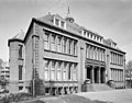
Category:Nederlandsche Heidemaatschappij (Arnhem)
Jump to navigation
Jump to search
| Object location | | View all coordinates using: OpenStreetMap |
|---|
 | |||||
| Upload media | |||||
| Instance of | |||||
|---|---|---|---|---|---|
| Location | Arnhem, Gelderland, Netherlands | ||||
| Street address |
| ||||
| Located on street |
| ||||
| Architect | |||||
| Heritage designation |
| ||||
| Inception |
| ||||
| Date of official opening |
| ||||
 | |||||
Nederlands: Nederlandsche Heidemaatschappij (Kantoorgebouw)
|
This is a category about rijksmonument number 516834
|
| Address |
|
Media in category "Nederlandsche Heidemaatschappij (Arnhem)"
The following 40 files are in this category, out of 40 total.
-
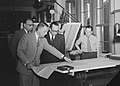 10 juni 1954, Bestanddeelnr 253-6543.jpg 3,290 × 2,365; 923 KB
-
 Arnhem 112347.jpg 4,128 × 3,096; 4.09 MB
-
 Arnhem Rijksmonument 516834 Ned.Heidemij Sickeszplein 1 entree.JPG 2,736 × 3,648; 3.33 MB
-
 Arnhem Rijksmonument 516834 Ned.Heidemij Sickeszplein 1.JPG 3,648 × 2,736; 3.21 MB
-

-
 Exterieur VOORGEVEL, INGANGSPARTIJ - Arnhem - 20339632 - RCE.jpg 943 × 1,200; 254 KB
-
 Gebouwen der nhm , Utrecht, Bestanddeelnr 194-0336.jpg 3,193 × 2,424; 1.35 MB
-
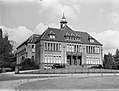
 Gebouwen en monumenten knhm, exterieurs, hoofdkantoren, knhm, Bestanddeelnr 162-0950.jpg 3,305 × 2,358; 1.19 MB
-
 Gebouwen en monumenten knhm, hoofdgebouwen, exterieurs, Bestanddeelnr 162-0889.jpg 3,305 × 2,358; 1.51 MB
-

-

-

-
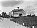
 Hoofdgebouwen, hoofdgebouw nhm, Madurodam, Bestanddeelnr 165-0132.jpg 3,302 × 2,374; 1.96 MB
-

-

-

-

-

-

-

-
-
-

-

-

-

-

-

-

-

-

-

-
-

-

-

-
 Overzicht van voor- en zijgevel - Arnhem - 20415472 - RCE.jpg 1,200 × 1,090; 268 KB
-
 Overzicht voorgevel en gedeelte linker zijgevel - Arnhem - 20359705 - RCE.jpg 1,200 × 942; 257 KB
-
 Overzicht voorgevel met torentje, kantoorgebouw - Arnhem - 20345311 - RCE.jpg 1,195 × 1,200; 363 KB
-
 Overzicht voorgevel met torentje, kantoorgebouw - Arnhem - 20345312 - RCE.jpg 1,190 × 1,200; 393 KB


_-_Arnhem_-_20372870_-_RCE.jpg)


