Category:Nickey Line
Jump to navigation
Jump to search
railway line in the UK   | |||||
| Upload media | |||||
| Instance of |
| ||||
|---|---|---|---|---|---|
| Part of |
| ||||
| Location | Hertfordshire, East of England, England | ||||
| Owned by | |||||
| Operator |
| ||||
| Date of official opening |
| ||||
| Date of official closure |
| ||||
| Length |
| ||||
| Terminus | |||||
| |||||
Subcategories
This category has the following 5 subcategories, out of 5 total.
B
H
- Harpenden railway station (66 F)
- Hemel Hempstead railway station (22 F)
Media in category "Nickey Line"
The following 50 files are in this category, out of 50 total.
-
 Ambrose Lane bridge - geograph.org.uk - 155660.jpg 480 × 640; 147 KB
-
 Ambrose Lane Bridge - geograph.org.uk - 990967.jpg 640 × 480; 129 KB
-
 Boxmoor railway station 1898.png 2,283 × 1,025; 1.82 MB
-
 Buckinghamshire railways, 1880.png 1,053 × 745; 171 KB
-
 Harpenden from above - geograph.org.uk - 155671.jpg 640 × 480; 154 KB
-
 Heath park halt map.png 1,286 × 1,951; 1.77 MB
-

-
 Hemel Hempstead, B487 Queensway - geograph.org.uk - 586121.jpg 640 × 480; 112 KB
-
 Hemel Hempstead, B487 Queensway - geograph.org.uk - 586125.jpg 640 × 480; 101 KB
-
 Hemel Hempstead, The Nicky Line - geograph.org.uk - 1257581.jpg 640 × 480; 149 KB
-
 Hemel Hempstead, The Nicky Line - geograph.org.uk - 585262.jpg 640 × 480; 169 KB
-
 Hemel Hempstead, The Nicky Line - geograph.org.uk - 585281.jpg 640 × 480; 177 KB
-
 Hemel Hempstead, The Nicky Line - geograph.org.uk - 586106.jpg 640 × 480; 169 KB
-
 Hemel Hempsted (Midland) railway station.jpg 1,599 × 1,047; 1.08 MB
-
 Hemel hempsted midland map.png 1,307 × 1,701; 1.34 MB
-
 Hemel hempsted midland map1924.png 1,862 × 1,495; 1.88 MB
-
 Hemel hempsted midland map2.png 1,307 × 1,268; 1.03 MB
-
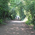
 Jogger on the Nicky Line - geograph.org.uk - 256090.jpg 427 × 640; 139 KB
-
 Keen Fields, Hemel Hempstead - geograph.org.uk - 145089.jpg 640 × 480; 65 KB
-
 NCN57 NICKEY LINE.JPG 1,600 × 1,600; 3.04 MB
-
 Nickey Line - geograph.org.uk - 2169931.jpg 640 × 480; 149 KB
-
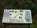 Nickey Line Information Board.jpg 2,832 × 2,128; 2.31 MB
-
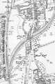
 Nickey Line map.png 1,157 × 1,034; 577 KB
-
 Nickey Line Sign Harpenden Ambrose Lane.jpg 2,832 × 2,128; 2.22 MB
-
 Nickey Line Sign Harpenden.jpg 2,128 × 2,832; 3.65 MB
-
 Nickey Line, Stairs at Hollybush Lane, Harpenden 1.jpg 3,000 × 4,000; 7.94 MB
-
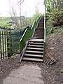 Nickey Line, Stairs at Hollybush Lane, Harpenden 2.jpg 3,000 × 4,000; 7.69 MB
-
 Nicky Line , Harpenden - geograph.org.uk - 532441.jpg 640 × 480; 90 KB
-
 Nicky Line - geograph.org.uk - 155654.jpg 480 × 640; 160 KB
-
 Nicky Line - geograph.org.uk - 990965.jpg 640 × 480; 100 KB
-
 Nicky Line Footpath - geograph.org.uk - 1234383.jpg 640 × 480; 108 KB
-
 Nicky Line Halt - geograph.org.uk - 155676.jpg 480 × 640; 145 KB
-

-
 Railway bridge over Queensway, Hemel Hempstead (1964).JPG 1,818 × 1,624; 934 KB
-
 Railway Line Harpenden - geograph.org.uk - 678259.jpg 640 × 480; 75 KB
-
 Railway sidings and station car park , Hemel Hempstead (geograph 2172382).jpg 2,560 × 1,920; 909 KB
-
 Redbourn, A5183 - B487 roundabout - geograph.org.uk - 142610.jpg 640 × 480; 89 KB
-
 Redbourn, The Nicky Line - geograph.org.uk - 142192.jpg 640 × 480; 152 KB
-
 Redbourn, The Nicky Line - geograph.org.uk - 143068.jpg 640 × 480; 142 KB
-
 Redbourn, The Nicky Line - geograph.org.uk - 143073.jpg 640 × 480; 138 KB
-

-

-
 River Ver south of Redbourn - geograph.org.uk - 142596.jpg 640 × 480; 142 KB
-
 Roundwood Halt Platform & Signal.jpg 2,832 × 2,128; 2.29 MB
-
 Roundwood Halt Signal.jpg 2,128 × 2,832; 2.31 MB
-
 The Nicky Line crosses the M1 - geograph.org.uk - 1535045.jpg 640 × 480; 102 KB
-
 The railway station, Hemel Hempstead (geograph 3091928).jpg 640 × 457; 153 KB
-
 The Victoria history of the County of Hertford Nickey Line.jpg 672 × 548; 170 KB
-
 Train Signal - geograph.org.uk - 990961.jpg 640 × 480; 150 KB
-
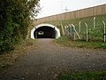
 Tunnel beneath the M1 - geograph.org.uk - 1535063.jpg 640 × 480; 56 KB


.jpg)


_railway_station.jpg)


.JPG)

.jpg)


.jpg)


