Category:Nieuwe Ginnekenstraat, Breda
Jump to navigation
Jump to search
| Object location | | View all coordinates using: OpenStreetMap |
|---|
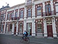
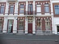
Nederlands: Afbeeldingen van de Nieuwe Ginnekenstraat, Breda in Breda in de provincie Noord-Brabant in het zuiden van Nederland. De Nieuwe Ginnekenstraat is een straat tussen het Van Coothplein en de Wilhelminastraat. Niet ver van het centrum van Breda.
street in Breda, the Netherlands | |||||
| Upload media | |||||
| Instance of | |||||
|---|---|---|---|---|---|
| Location | Breda, North Brabant, Netherlands | ||||
| Street address |
| ||||
 | |||||
Subcategories
This category has the following 14 subcategories, out of 14 total.
Media in category "Nieuwe Ginnekenstraat, Breda"
The following 41 files are in this category, out of 41 total.
-
 En lager, overzicht voorgevels - Breda - 20041040 - RCE.jpg 1,200 × 948; 222 KB
-
 En lager, overzicht voorgevels - Breda - 20041044 - RCE.jpg 1,200 × 947; 210 KB
-
 En lager, straat overzicht - Breda - 20041043 - RCE.jpg 1,200 × 945; 239 KB
-
 Nieuwe Ginnekenstraat Breda richting Singel.jpg 4,032 × 2,268; 3.69 MB
-
 Nieuwe Ginnekenstraat P1530663.jpg 4,000 × 2,672; 5.09 MB
-
 Nieuwe Ginnekenstraat, Breda DSCF0595.jpg 2,048 × 1,536; 1.58 MB
-
 Nieuwe Ginnekenstraat, Breda DSCF0604.jpg 2,048 × 1,536; 1.59 MB
-
 Nieuwe Ginnekenstraat, Breda DSCF0605.jpg 2,048 × 1,536; 1.61 MB
-
 Nieuwe Ginnekenstraat, Breda DSCF0610.jpg 2,048 × 1,536; 1.54 MB
-
 Nieuwe Ginnekenstraat, Breda DSCF0611.jpg 2,048 × 1,536; 1.5 MB
-
 Nieuwe Ginnekenstraat, Breda DSCF0612.jpg 1,536 × 2,048; 1.5 MB
-
 Nieuwe Ginnekenstraat, Breda DSCF0613.jpg 1,718 × 1,064; 477 KB
-
 Nieuwe Ginnekenstraat, Breda DSCF0614.jpg 2,048 × 1,536; 1.57 MB
-
 Nieuwe Ginnekenstraat, Breda DSCF0615.jpg 2,048 × 1,536; 1.58 MB
-
 Nieuwe Ginnekenstraat, Breda DSCF0616.jpg 2,048 × 1,536; 1.47 MB
-
 Nieuwe Ginnekenstraat, Breda DSCF0617.jpg 2,048 × 1,536; 1.54 MB
-
 Nieuwe Ginnekenstraat, Breda DSCF0619.jpg 2,048 × 1,536; 1.54 MB
-
 Nieuwe Ginnekenstraat, Breda DSCF0620.jpg 2,048 × 1,536; 1.52 MB
-
 Nieuwe Ginnekenstraat, Breda DSCF0621.jpg 2,048 × 1,536; 1.48 MB
-
 Nieuwe Ginnekenstraat, Breda DSCF0623.jpg 2,048 × 1,536; 1.57 MB
-
 Nieuwe Ginnekenstraat, Breda DSCF0624.jpg 1,536 × 2,048; 1.5 MB
-
 Nieuwe Ginnekenstraat, Breda DSCF0625.jpg 2,048 × 1,536; 1.48 MB
-
 Nieuwe Ginnekenstraat, Breda I01582.jpg 2,626 × 1,709; 1.08 MB
-
 Nieuwe Ginnekenstraat, Breda P1010498.jpg 3,264 × 2,448; 3.73 MB
-
 Nieuwe Ginnekenstraat, Breda P1600049.jpg 4,000 × 2,672; 5.5 MB
-
 Nieuwe Ginnekenstraat, Breda P1600053.jpg 4,000 × 2,672; 4.84 MB
-
 Nieuwe Ginnekenstraat, Breda P1600054.jpg 4,000 × 2,672; 5.76 MB
-
 Nieuwe Ginnekenstraat, BredaDSCF0622.jpg 1,536 × 2,048; 1.56 MB
-
 Overzicht - Breda - 20041037 - RCE.jpg 1,200 × 788; 216 KB
-
 Overzicht - Breda - 20041039 - RCE.jpg 1,200 × 788; 222 KB
-
 Overzicht - Breda - 20041041 - RCE.jpg 1,200 × 788; 234 KB
-
 Overzicht - Breda - 20041042 - RCE.jpg 1,200 × 788; 208 KB
-
 Overzicht - Breda - 20041045 - RCE.jpg 1,200 × 788; 202 KB
-
 Overzicht - Breda - 20041046 - RCE.jpg 1,200 × 788; 221 KB
-
 P1010503 copyNieuw Ginnekenstraat.jpg 3,264 × 2,448; 1.83 MB
-
 P1030356 copyNieuwe Ginnekenstraat.jpg 3,264 × 2,448; 1.74 MB
-
 P1030358 copyNieuwe Ginnekenstraat.jpg 3,264 × 2,448; 1.94 MB
-
 P1030359 copyWilhelminabrug.jpg 3,264 × 2,448; 1.96 MB
-
 The Yellow Island DSCF0609.jpg 1,536 × 2,048; 1.47 MB
-
 Wilhelminastraat Breda P1050731.JPG 3,264 × 2,448; 3.52 MB
-
 Wilhelminastraat, Breda P1600051.jpg 4,000 × 2,672; 5.7 MB


