Category:Nieuwe Zandweg 14, Linschoten
Jump to navigation
Jump to search
| Object location | | View all coordinates using: OpenStreetMap |
|---|
 | |||||
| Upload media | |||||
| Instance of | |||||
|---|---|---|---|---|---|
| Location | Linschoten, Utrecht, Netherlands | ||||
| Street address |
| ||||
| Located on street |
| ||||
| Heritage designation |
| ||||
 | |||||
|
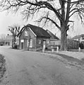
This is a category about rijksmonument number 25978
|
| Address |
|
Media in category "Nieuwe Zandweg 14, Linschoten"
The following 6 files are in this category, out of 6 total.
-
 Linker zij- en achtergevel - Linschoten - 20140634 - RCE.jpg 1,200 × 1,198; 374 KB
-
 Linschoten Nieuwe Zandweg Tolhuisje.JPG 4,288 × 2,848; 3.11 MB
-
 Linschoten nieuwe zandweg.jpg 2,592 × 1,944; 2.15 MB
-
 Nieuwe Zandweg 14-1.jpg 1,500 × 1,000; 604 KB
-
 Nieuwe Zandweg 14-2.JPG 1,000 × 1,500; 597 KB
-
 Voor- en rechter zijgevel - Linschoten - 20140633 - RCE.jpg 1,193 × 1,200; 420 KB


