Category:Nieuwestad 46, Leeuwarden
Jump to navigation
Jump to search
| Object location | | View all coordinates using: OpenStreetMap |
|---|
 | |||||
| Upload media | |||||
| Instance of |
| ||||
|---|---|---|---|---|---|
| Location | Leeuwarden, Friesland, Netherlands | ||||
| Heritage designation |
| ||||
 | |||||
|
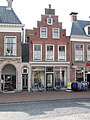
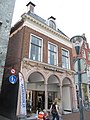
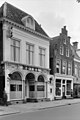
This is a category about rijksmonument number 24303
|
| Address |
|
Media in category "Nieuwestad 46, Leeuwarden"
The following 5 files are in this category, out of 5 total.
-
 Kleine Kerkstraat - Leeuwarden - 20130566 - RCE.jpg 1,190 × 1,200; 261 KB
-
 RM24302 Leeuwarden - Nieuwestad 44.jpg 1,944 × 2,592; 1.42 MB
-
 RM24303 Leeuwarden - Nieuwestad 46.jpg 1,944 × 2,592; 1.43 MB
-
 RM24304 Leeuwarden - Nieuwestad 48.jpg 1,944 × 2,592; 1.25 MB
-
 Voorgevels - Leeuwarden - 20132651 - RCE.jpg 801 × 1,200; 167 KB


