Category:Nonnenstraat 78, Zaltbommel
Jump to navigation
Jump to search
| Object location | | View all coordinates using: OpenStreetMap |
|---|
 | |||||
| Upload media | |||||
| Instance of |
| ||||
|---|---|---|---|---|---|
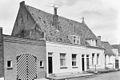
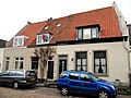
| Location | Zaltbommel, Gelderland, Netherlands | ||||
| Street address |
| ||||
| Heritage designation |
| ||||
 | |||||
|
This is a category about rijksmonument number 40241
|
| Address |
|
Media in category "Nonnenstraat 78, Zaltbommel"
The following 4 files are in this category, out of 4 total.
-
 Gevels - Zaltbommel - 20220491 - RCE.jpg 1,200 × 802; 235 KB
-
 Nonnenstraat 74-76-78.jpg 4,000 × 3,000; 1,012 KB
-
 Overzicht - Zaltbommel - 20220488 - RCE.jpg 1,200 × 808; 196 KB
-
 Overzicht Nonnenstraat naar het westen - Zaltbommel - 20219575 - RCE.jpg 1,190 × 1,200; 250 KB


