Category:Old Goris (Kores)
Jump to navigation
Jump to search
| Object location | | View all coordinates using: OpenStreetMap |
|---|
|
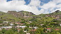
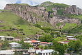
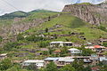
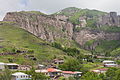
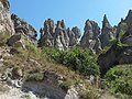
This is a category about a monument in Armenia identified by the ID 9.3/2
|
This is a category about a natural site in Armenia identified by the ID SU-NH010
|
Հայերեն: Հին Գորիսի («Կյորես»)
 | |||||
| Upload media | |||||
| Instance of | |||||
|---|---|---|---|---|---|
| Location | Goris, Syunik Province, Armenia | ||||
| Located in or next to body of water |
| ||||
| Has part(s) |
| ||||
| Heritage designation | |||||
 | |||||
Subcategories
This category has only the following subcategory.
S
Media in category "Old Goris (Kores)"
The following 46 files are in this category, out of 46 total.
-
 2014 Prowincja Sjunik, Goris, Widok na Stary Goris (Kores) (01).jpg 4,254 × 2,393; 8.02 MB
-
 2014 Prowincja Sjunik, Goris, Widok na Stary Goris (Kores) (02).jpg 4,284 × 2,860; 10.66 MB
-
 2014 Prowincja Sjunik, Goris, Widok na Stary Goris (Kores) (03).jpg 4,662 × 3,113; 12.23 MB
-
 2014 Prowincja Sjunik, Goris, Widok na Stary Goris (Kores) (04).jpg 4,715 × 3,142; 11 MB
-
 2014 Prowincja Sjunik, Goris, Widok na Stary Goris (Kores) (06).jpg 4,525 × 3,023; 10.95 MB
-
 2014 Prowincja Sjunik, Goris, Widok na Stary Goris (Kores) (07).jpg 4,645 × 3,100; 13.74 MB
-
 2014 Prowincja Sjunik, Goris, Widok na Stary Goris (Kores) (08).jpg 4,736 × 2,664; 11.78 MB
-
 2014 Prowincja Sjunik, Goris, Widok na Stary Goris (Kores) (09).jpg 4,752 × 3,168; 13.72 MB
-
 2014 Prowincja Sjunik, Goris, Widok na Stary Goris (Kores) (10).jpg 3,079 × 4,631; 12.86 MB
-
 2014 Prowincja Sjunik, Goris, Widok na Stary Goris (Kores) (11).jpg 4,636 × 2,611; 10.83 MB
-
 2014 Prowincja Sjunik, Goris, Widok na Stary Goris (Kores) (12).jpg 4,612 × 3,074; 12.71 MB
-
 2014 Prowincja Sjunik, Goris, Widok na Stary Goris (Kores) (13).jpg 4,461 × 2,974; 12.08 MB
-
 2014 Prowincja Sjunik, Goris, Widok na Stary Goris (Kores) (14).jpg 4,449 × 2,966; 11.8 MB
-
 2014 Prowincja Sjunik, Goris, Widok na Stary Goris (Kores) (15).jpg 4,727 × 2,659; 11.68 MB
-
 2014 Prowincja Sjunik, Goris, Widok na Stary Goris (Kores) (16).jpg 3,091 × 4,642; 13.55 MB
-
 Cave Dwellings (37482320172).jpg 1,024 × 768; 154 KB
-
 Cave in Old Goris.JPG 3,264 × 2,448; 2.16 MB
-
 Crow Ark Goris.jpg 3,488 × 2,325; 2.33 MB
-
 Goris – cemetery 2.jpg 3,500 × 2,333; 2.05 MB
-
 Goris – old town 1.jpg 3,500 × 2,333; 2.26 MB
-
 Goris – old town 2.jpg 3,500 × 2,333; 2.1 MB
-
 IMAG0209-Բուրգեր.jpg 2,592 × 1,728; 1.51 MB
-
 IMAG0239-PANO+9.jpg 6,849 × 1,407; 3.3 MB
-
 IMAG0246-899.jpg 2,592 × 1,728; 1.34 MB
-
 Kyores 0414.jpg 2,048 × 1,536; 538 KB
-
 Kyores 0416.jpg 2,048 × 1,536; 506 KB
-
 Kyores 0417.jpg 2,048 × 1,536; 514 KB
-
 Kyores 0418.jpg 2,048 × 1,536; 556 KB
-
 Kyores 0440.jpg 2,048 × 1,536; 241 KB
-
 Kyores.jpg 2,048 × 1,536; 570 KB
-
 Old Goris 1.JPG 3,264 × 2,448; 2.42 MB
-
 Old Goris, houses in the rocks 1.jpg 2,576 × 1,932; 1.22 MB
-
 Old Goris, houses in the rocks.jpg 2,576 × 1,932; 1.22 MB
-
 Old Goris.jpeg 640 × 480; 143 KB
-
 Stone Pyramids in Goris.jpg 4,365 × 2,910; 3.39 MB
-
 Xacher dzor, bnakeli qarayreri hamalir.JPG 4,000 × 3,000; 5.89 MB
-
 Xacheri dzor, bnakeli qarayreri hamalir.JPG 4,000 × 3,000; 5.01 MB
-
 Панорама Гориса 1.jpg 10,382 × 3,750; 13.76 MB
-
 Բնակատեղի - գյուղատեղի Հին Գորիս «Կյորես» 04.jpg 4,288 × 3,216; 2.57 MB
-
 Բնակատեղի - գյուղատեղի Հին Գորիս «Կյորես» 05.jpg 4,288 × 3,216; 2.53 MB
-
 Բնակատեղի - գյուղատեղի Հին Գորիս «Կյորես» 06.jpg 4,288 × 3,216; 2.59 MB
-
 Բնակատեղի - գյուղատեղի Հին Գորիս «Կյորես» 07.jpg 4,288 × 3,216; 2.63 MB
-
 Բնակատեղի - գյուղատեղի Հին Գորիս «Կյորես» 09.jpg 4,288 × 3,216; 2.69 MB
-
 Գորիս.jpg 3,233 × 2,164; 5.41 MB
-
 Հին Գորիս - Old Goris (մինչև - until 1898).jpg 1,028 × 769; 418 KB
-
 Հին Գորիս.jpg 3,612 × 2,278; 2.12 MB
_(01).jpg)
_(02).jpg)
_(03).jpg)
_(04).jpg)
_(06).jpg)
_(07).jpg)
_(08).jpg)
_(09).jpg)
_(10).jpg)
_(11).jpg)
_(12).jpg)
_(13).jpg)
_(14).jpg)
_(15).jpg)
_(16).jpg)
.jpg)


.jpg)
