Category:Old Rectory, St Mary's, Walton
Jump to navigation
Jump to search
| Object location | | View all coordinates using: OpenStreetMap |
|---|
This is a category about listed building number 1360215. |
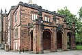
clergy house in Walton, Liverpool, Merseyside, England, UK  | |||||
| Upload media | |||||
| Instance of | |||||
|---|---|---|---|---|---|
| Location | Walton, Liverpool, Merseyside, North West England, England | ||||
| Heritage designation |
| ||||
 | |||||
Subcategories
This category has only the following subcategory.
Media in category "Old Rectory, St Mary's, Walton"
The following 5 files are in this category, out of 5 total.
-
 Alsop High School, Liverpool L4 (2).JPG 4,608 × 3,456; 3.64 MB
-
 Old Rectory, St Mary's, Walton 1.jpg 4,782 × 3,303; 8.89 MB
-
 Old Rectory, St Mary's, Walton 2.jpg 4,893 × 3,312; 10.12 MB
-
 Old Rectory, St Mary's, Walton 3.jpg 4,428 × 3,048; 8.69 MB
-
 Old Rectory, St Mary's, Walton.jpg 4,338 × 3,222; 8.92 MB
.JPG)


