Category:Old maps of Alastaro
Jump to navigation
Jump to search
Media in category "Old maps of Alastaro"
The following 11 files are in this category, out of 11 total.
-
 Parish map of Alastaro in Finland, square 2111 03, 2111 02.jpg 6,599 × 7,121; 2.8 MB
-
 Parish map of Alastaro in Finland, square 2111 05, 2111 08.jpg 6,990 × 6,825; 3.22 MB
-
 Parish map of Alastaro in Finland, square 2111 06.jpg 6,514 × 6,066; 3.03 MB
-
 Parish map of Alastaro in Finland, square 2111 09, 2111 08.jpg 5,734 × 7,516; 2.8 MB
-
 Parish map of Alastaro in Finland, square 2112 04, 2112 07.jpg 7,089 × 6,528; 2.24 MB
-
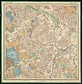
 Senate Atlas, 1870–1907. Sheet XIII 19 Loimaa.jpg 7,041 × 7,104; 7.07 MB
-
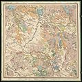
 Senate Atlas, 1870–1907. Sheet XIV 18 Alastaro.jpg 7,044 × 7,139; 7.19 MB
-
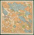
 Senate Atlas, 1870–1907. Sheet XIV 19 Alastaro.jpg 7,067 × 7,195; 7.19 MB
-
 Senate Atlas, 1870–1907. Sheet XIV 20 Loimaa.jpg 7,068 × 7,123; 7.04 MB
-
 Senate Atlas, 1870–1907. Sheet XV 19 Vampula.jpg 6,993 × 7,113; 7.92 MB
-
 Senate Atlas, 1870–1907. Sheet XV 20 Punkalaidun.jpg 6,996 × 7,157; 8.58 MB


