Category:Old maps of Asperg
Jump to navigation
Jump to search
Historische Karten von Asperg im Kreis Ludwigsburg
Media in category "Old maps of Asperg"
The following 7 files are in this category, out of 7 total.
-
 1605 Greininger Beamptung Schickhardt.jpg 1,553 × 1,240; 1.12 MB
-
 1776 Forste+Alleen um den Asperg Labw-1-479799-1 B.jpg 1,577 × 2,033; 3.7 MB
-
 Festung Hohenasperg 1669.jpg 4,186 × 3,337; 3.23 MB
-
 K Grüningen Amtsbezirk Schickhardt fol XI um 1605.jpg 1,587 × 1,078; 2.68 MB
-
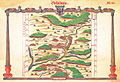
 Kiesersche Forstkarte Nr. 160 Aßberg (Asperg).jpg 1,024 × 753; 354 KB
-
 Kiesersche Forstkarte Nr. 160 Detail Under Assberg (Asperg).jpg 1,024 × 745; 374 KB
-


.jpg)
.jpg)
_Landesarchiv_BW_EL_68_VI_Nr_3232_Bild_1_(2-5303600-1).png)