Category:Old maps of Connecticut from the Norman B. Leventhal Map Center
Jump to navigation
Jump to search
Subcategories
This category has only the following subcategory.
1
Media in category "Old maps of Connecticut from the Norman B. Leventhal Map Center"
The following 9 files are in this category, out of 9 total.
-
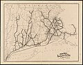
 1838 Southern New England railroad map.jpg 7,204 × 6,096; 39.17 MB
-
 1894 New York, New Haven and Hartford Railroad map.jpg 5,761 × 4,560; 3.01 MB
-
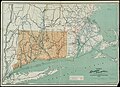 1895 Connecticut railroad map.jpg 10,157 × 7,340; 9.12 MB
-
 1918 New map of the city of Norwich G3784.N8 1918 .jpg 8,547 × 6,831; 6.24 MB
-
 OldHartfordMap.jpg 10,080 × 7,712; 34.46 MB
-
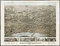
 Stonington railroad wharf on 1879 bird's-eye map.jpg 2,343 × 1,468; 732 KB
-
 Stonington station on 1879 bird's-eye map .jpg 1,146 × 770; 152 KB
-
 View of Putnam, Conn - 1877 G3784.P9A3 1877O43.jpg 8,200 × 6,496; 7.63 MB
-
 View of Stonington, Conn - 1879 G3784.S8A3 1879O43.jpg 8,200 × 6,584; 6.32 MB


