Category:Old maps of Gilpin County, Colorado
Jump to navigation
Jump to search
Subcategories
This category has the following 2 subcategories, out of 2 total.
Media in category "Old maps of Gilpin County, Colorado"
The following 11 files are in this category, out of 11 total.
-

-
 Central City and Blackhawk, Colorado, 1873 - DPLA - d1274234ba4c250b72700181e8a896e0.jpg 7,000 × 5,574; 6.88 MB
-
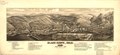
 Black Hawk, Colo. 1882. LOC 75693120.jpg 6,320 × 2,936; 2.81 MB
-
 Black Hawk, Colo. 1882. LOC 75693120.tif 6,320 × 2,936; 53.09 MB
-
 Map of great western Central City - DPLA - 28858e3f87d1bbdf3603a9fe74afeaae.jpg 7,000 × 5,519; 5.76 MB
-
 Map of Gilpin Co., Colo. - DPLA - 337f0de111963c22003de78799daa7a3.jpg 9,000 × 7,077; 11.15 MB
-
 Old Town Mine plat with map - DPLA - ffc206aae71ba3c96eb014283650f56d.jpg 6,000 × 3,070; 2.76 MB
-
 Colorado -Adams County - Las Animas County (part)- - NARA - 17443770 (page 1098).jpg 4,293 × 3,652; 2.68 MB
-
 Colorado -Adams County - Las Animas County (part)- - NARA - 17443770 (page 1106).jpg 4,056 × 3,512; 2.33 MB
-
 Colorado -Adams County - Las Animas County (part)- - NARA - 17443770 (page 474).jpg 4,100 × 3,560; 2.52 MB
-
 Colorado -Adams County - Las Animas County (part)- - NARA - 17443770 (page 482).jpg 4,082 × 3,528; 2.3 MB


-_-_NARA_-_17443770_(page_1098).jpg)
-_-_NARA_-_17443770_(page_1106).jpg)
-_-_NARA_-_17443770_(page_474).jpg)
-_-_NARA_-_17443770_(page_482).jpg)