Category:Opril Grote Markt 9, Goes
Jump to navigation
Jump to search
| Object location | | View all coordinates using: OpenStreetMap |
|---|
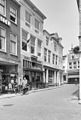
building in Goes, Netherlands  | |||||
| Upload media | |||||
| Instance of | |||||
|---|---|---|---|---|---|
| Location | Goes, Zeeland, Netherlands | ||||
| Street address |
| ||||
| Located on street |
| ||||
| Heritage designation |
| ||||
 | |||||
|
This is a category about rijksmonument number 16369
|
| Address |
|
Media in category "Opril Grote Markt 9, Goes"
The following 3 files are in this category, out of 3 total.
-
 Goes Opril Grote Markt 11.jpg 1,712 × 2,288; 718 KB
-
 Goes Opril Grote Markt 9.jpg 1,712 × 2,288; 729 KB
-
 Voorgevels - Goes - 20079844 - RCE.jpg 810 × 1,200; 199 KB

