Category:Ottema (Uithuizen)
Jump to navigation
Jump to search
| Object location | | View all coordinates using: OpenStreetMap |
|---|
 | |||||
| Upload media | |||||
| Instance of | |||||
|---|---|---|---|---|---|
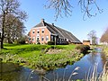
| Location | Uithuizen, Groningen, Netherlands | ||||
| Street address |
| ||||
| Located on street |
| ||||
| Heritage designation |
| ||||
 | |||||
Nederlands: Boerderij Ottoma
|
This is a category about rijksmonument number 21310
|
| Address |
|
Media in category "Ottema (Uithuizen)"
The following 3 files are in this category, out of 3 total.
-
 "Ottoma", Oude Dijksterweg, vooraanzicht - Uithuizen - 20211298 - RCE.jpg 1,192 × 1,200; 291 KB
-
 "Ottoma", rechterzijde - Uithuizen - 20211299 - RCE.jpg 1,195 × 1,200; 292 KB
-
 Ottoma Uithuizen.jpg 1,789 × 1,342; 733 KB

