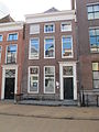
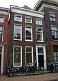
Category:Oude Boteringestraat 42 (Groningen)
Jump to navigation
Jump to search
| Object location | | View all coordinates using: OpenStreetMap |
|---|
house in Groningen, Netherlands  | |||||
| Upload media | |||||
| Instance of | |||||
|---|---|---|---|---|---|
| Location | Groningen, Netherlands | ||||
| Street address |
| ||||
| Heritage designation |
| ||||
 | |||||
|
This is a category about rijksmonument number 18634
|
| Address |
|
Media in category "Oude Boteringestraat 42 (Groningen)"
The following 3 files are in this category, out of 3 total.
-
 LG-Groningen- Oude Boteringestraat 42.JPG 2,112 × 2,816; 1.69 MB
-
 Oude Boteringestraat 42 - 18634.jpg 1,368 × 1,920; 804 KB
-
 Voorgevel - Groningen - 20093588 - RCE.jpg 816 × 1,200; 250 KB

