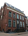
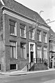
Category:Oude Boteringestraat 72 (Groningen)
Jump to navigation
Jump to search
| Object location | | View all coordinates using: OpenStreetMap |
|---|
building in Groningen, Netherlands  | |||||
| Upload media | |||||
| Instance of | |||||
|---|---|---|---|---|---|
| Location | Groningen, Netherlands | ||||
| Street address |
| ||||
| Heritage designation |
| ||||
 | |||||
|
This is a category about rijksmonument number 18639
|
| Address |
|
Media in category "Oude Boteringestraat 72 (Groningen)"
The following 3 files are in this category, out of 3 total.
-
 Oude Boteringestraat 72 - 18639.jpg 1,424 × 1,833; 797 KB
-
 Voorgevel - Groningen - 20093601 - RCE.jpg 801 × 1,200; 256 KB
-
 Zijgevel - Groningen - 20093602 - RCE.jpg 807 × 1,200; 259 KB

