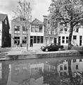
Category:Oude Haven 30, Schoonhoven
Jump to navigation
Jump to search
| Object location | | View all coordinates using: OpenStreetMap |
|---|
building in Krimpenerwaard, Netherlands  | |||||
| Upload media | |||||
| Instance of | |||||
|---|---|---|---|---|---|
| Location | Schoonhoven, Krimpenerwaard, South Holland, Netherlands | ||||
| Street address |
| ||||
| Located on street | |||||
| Heritage designation |
| ||||
 | |||||
|
This is a category about rijksmonument number 33521
|
| Address |
|
Media in category "Oude Haven 30, Schoonhoven"
The following 7 files are in this category, out of 7 total.
-
 Exterieur OVERZICHT VOORGEVEL - Schoonhoven - 20301797 - RCE.jpg 1,197 × 1,200; 450 KB
-
 Exterieur OVERZICHT VOORGEVELS - Schoonhoven - 20301792 - RCE.jpg 1,181 × 1,200; 374 KB
-
 Exterieur OVERZICHT VOORGEVELS - Schoonhoven - 20301794 - RCE.jpg 1,183 × 1,200; 443 KB
-
 INTERIEUR, GEDEELTE TRAPPENHUIS - Schoonhoven - 20301795 - RCE.jpg 1,200 × 1,200; 290 KB
-
 INTERIEUR, TRAPPENHUIS, PLAFOND, DETAIL - Schoonhoven - 20301796 - RCE.jpg 1,190 × 1,200; 217 KB
-
 RM33521 Schoonhoven - Oude Haven 30.jpg 1,944 × 2,592; 1.74 MB
-
 Voorgevels - Schoonhoven - 20198716 - RCE.jpg 815 × 1,200; 237 KB


