Category:Outwoods, East Staffordshire
Jump to navigation
Jump to search
English: Outwoods is a civil parish in the English county of Staffordshire. Once a village it is now a suburb on the flanks of the town of Burton upon Trent separated from the town by the A38 road.
civil parish in East Staffordshire, UK | |||||
| Upload media | |||||
| Instance of | |||||
|---|---|---|---|---|---|
| Location | East Staffordshire, Staffordshire, West Midlands, England | ||||
 | |||||
Media in category "Outwoods, East Staffordshire"
The following 47 files are in this category, out of 47 total.
-
 A grassy field - geograph.org.uk - 5868208.jpg 2,000 × 1,333; 2.31 MB
-
 A reedy pond - geograph.org.uk - 6223907.jpg 1,280 × 960; 724 KB
-
 Allotments off Forest Road - geograph.org.uk - 3422947.jpg 640 × 480; 75 KB
-
 B5017 heading east - geograph.org.uk - 3422934.jpg 640 × 480; 87 KB
-
 Beamhill Road - geograph.org.uk - 5868243.jpg 2,000 × 1,333; 2.39 MB
-
 Boundary post on Outwoods Hills - geograph.org.uk - 4142099.jpg 960 × 1,280; 489 KB
-
 Boundary post, Tutbury Road - geograph.org.uk - 3987093.jpg 960 × 1,280; 484 KB
-
 Bricklow House - geograph.org.uk - 6271729.jpg 1,280 × 960; 303 KB
-
 Bridleway near Anslow Park Woodlands - geograph.org.uk - 5584673.jpg 1,600 × 1,200; 322 KB
-
 Children's play area - geograph.org.uk - 6223904.jpg 1,280 × 960; 433 KB
-
 Farmland off Harehedge Lane - geograph.org.uk - 3423219.jpg 640 × 480; 73 KB
-
 Field entrance off the B5017 - geograph.org.uk - 3422929.jpg 640 × 480; 74 KB
-
 Footpath towards Bungalow Farm and Outwoods - geograph.org.uk - 5584677.jpg 1,600 × 1,200; 375 KB
-
 Harehedge Lane - geograph.org.uk - 3423223.jpg 640 × 480; 75 KB
-
 Henhurst Field, southeast of Anslow - geograph.org.uk - 5584664.jpg 1,600 × 1,200; 347 KB
-
 Henhurst Hill - geograph.org.uk - 5868195.jpg 2,000 × 1,333; 2 MB
-
 Henhurst Ridge - geograph.org.uk - 3422923.jpg 640 × 480; 68 KB
-
 Houses on Henhurst Hill - geograph.org.uk - 3422927.jpg 640 × 480; 65 KB
-
 King Road - geograph.org.uk - 5868203.jpg 2,000 × 1,333; 1.8 MB
-
 Kitling Greaves Lane - geograph.org.uk - 6223902.jpg 1,280 × 960; 612 KB
-
 Looking across the fields - geograph.org.uk - 5868251.jpg 2,000 × 1,333; 2.48 MB
-
 Manicured Footpath - geograph.org.uk - 197570.jpg 640 × 480; 84 KB
-
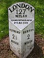
 Milepost at Outwoods Cross - geograph.org.uk - 3987080.jpg 960 × 1,280; 569 KB
-
 Milepost at Outwoods Cross - geograph.org.uk - 3987091.jpg 1,280 × 937; 451 KB
-
 Milepost at SK2206623928.jpg 492 × 701; 67 KB
-
 Milepost at SK2345725992.jpg 1,298 × 1,704; 409 KB
-
 Outwoods Cross - geograph.org.uk - 3987081.jpg 960 × 1,280; 428 KB
-
 Outwoods Cross - geograph.org.uk - 3987089.jpg 1,280 × 960; 293 KB
-
 Outwoods Cross, Beam Hill postbox ref DE13 1084 - geograph.org.uk - 3987086.jpg 960 × 1,280; 517 KB
-
 Public footpath through wood - geograph.org.uk - 669870.jpg 640 × 480; 132 KB
-
-
 Recreation ground off Forest Road - geograph.org.uk - 3422940.jpg 640 × 480; 97 KB
-
 Rolleston Road - geograph.org.uk - 3423225.jpg 640 × 480; 80 KB
-

-
 Shobnall Brook - geograph.org.uk - 6188522.jpg 1,280 × 960; 705 KB
-
 Shobnall Community Centre - geograph.org.uk - 3422952.jpg 640 × 441; 57 KB
-
 Shobnall Road (B5017), heading east - geograph.org.uk - 3422961.jpg 640 × 480; 63 KB
-
 St Modwen's Catholic primary school - geograph.org.uk - 6223911.jpg 1,280 × 960; 489 KB
-
 St. George's Road - geograph.org.uk - 5868222.jpg 2,000 × 1,333; 1.82 MB
-
 Staffordshire - Burton to Uttoxeter road milepost at SK220239, 2008.jpg 2,131 × 1,439; 625 KB
-
 The Brickmakers Arms, Upper Outwood - geograph.org.uk - 276267.jpg 640 × 480; 69 KB
-
 The bridge at Coley Mill - geograph.org.uk - 1073062.jpg 640 × 480; 121 KB
-
 Tutbury Road A511 Horninglow - geograph.org.uk - 5430072.jpg 1,600 × 1,200; 387 KB
-
 Tutbury Road at Forest Rdge Way - geograph.org.uk - 3987097.jpg 1,280 × 960; 304 KB
-
 View from Outwoods Hills - geograph.org.uk - 4142089.jpg 1,280 × 960; 246 KB
-
 View from Outwoods Hills - geograph.org.uk - 4142092.jpg 1,280 × 960; 325 KB
-
 Wrapped hay bales by Longhedge Lane - geograph.org.uk - 6271790.jpg 1,280 × 960; 388 KB


,_heading_east_-_geograph.org.uk_-_3422961.jpg)


