Category:Pajottenland
Vai alla navigazione
Vai alla ricerca
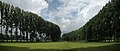
English: The Pajottenland (in English occasionally Payottenland) is a part of the Flemish Brabant province west of the Brussels Capital Region, also called Tuscany of the North. The Pajottenland is predominantly farmland, with occasional gently rolling hills. The area has historically provided food and drink for the citizens of Brussels, especially Lambic beers, which are only produced here and in the Senne valley where Brussels is located.
Français : Le Pajottenland, au sud-ouest de Bruxelles, en Belgique, souvent baptisée la Toscane du Nord, à la différence que le houblon et la bière, et plus particulièrement la gueuze, y remplacent la vigne et le vin, est une région agricole très fertile et vallonnée, entre les rivières Senne et Dendre, qui jouxte l'agglomération d'Anderlecht. Seule la partie ouest (Neerpede) de cette commune bruxelloise fait partie du Pajottenland. Les autres communes se trouvant dans cette région sont Affligem, Asse, Bever, Dilbeek, Galmaarden, Gooik, Herne, Lennik, Liedekerke, Pepingen, Roosdaal, Sint-Pieters-Leeuw et Ternat
Nederlands: Het Pajottenland is een zachtheuvelende, vruchtbare, agrarische streek ten zuidwesten van Brussel in de provincie Vlaams-Brabant tussen de rivieren de Dender en de Zenne. Het wordt ook wel het Toscane van de Lage Landen genoemd en het Land van Bruegel . Het is tegenwoordig vooral bekend voor zijn streekproduct Lambiek (bier) en de afgeleide dranken Faro, Kriek en vooral Geuze. Aangrenzende steden zijn Brussel, Halle, Edingen, Geraardsbergen, Ninove en Aalst. Inwoners van dit gebied heten Pajotten, enkelvoud Pajot.
area in Belgium   | |||||
| Carica un file multimediale | |||||
| Istanza di | |||||
|---|---|---|---|---|---|
| Parte di |
| ||||
| Prende il nome da |
| ||||
| Luogo | |||||
| Consiste di | |||||
| Punto più alto | |||||
 | |||||
Sottocategorie
Questa categoria contiene le 17 sottocategorie indicate di seguito, su un totale di 17.
File nella categoria "Pajottenland"
Questa categoria contiene 49 file, indicati di seguito, su un totale di 49.
-
 Afb9 Streekbord - Roosdaal.jpg 3 000 × 2 000; 5,03 MB
-
 Boerkozen einde 19de eeuw.jpg 627 × 627; 43 KB
-
 Brabants trekpaard - Vollezele.jpg 5 142 × 3 888; 4,27 MB
-
 Congoberg 01.jpg 5 472 × 3 648; 9,25 MB
-
 Congoberg 02.jpg 5 472 × 3 648; 7,83 MB
-
 Congoberg 03.jpg 5 472 × 3 648; 9,24 MB
-
 Congoberg 04.jpg 5 472 × 3 648; 7,81 MB
-
 Congoberg 07.jpg 5 472 × 3 648; 6,67 MB
-
 Congoberg 08.jpg 5 472 × 3 648; 7,21 MB
-
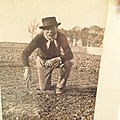
 F.J.DE GRONCKEL-RDW-02.jpg 711 × 843; 387 KB
-
 Galmaarden - Vollezele - Congobergstraat (2021-05-02 12-16-26.jpg 6 240 × 4 160; 14,01 MB
-
 Galmaarden - Vollezele - Congobergstraat 3 (2021-05-02 12-02-07.jpg 5 550 × 3 700; 9,75 MB
-
 Galmaarden - Vollezele - Congobergstraat 3 (2021-05-02 12-04-35.jpg 5 935 × 3 957; 8,19 MB
-
 Galmaarden - Vollezele - Hof te Leysbroek - Repingestraat 91 (2011-04-25 14-53-49).jpg 3 264 × 2 448; 4,78 MB
-
 Graven De Gronckel-Lennik-RDW-03.jpg 860 × 720; 654 KB
-
 Hopranken.jpg 4 024 × 6 048; 2,87 MB
-
 Kaart 1958 Belgische verdedigingslinie detail zuidelijke aftakking.jpg 6 000 × 4 000; 5,09 MB
-

-
 Kerk van Pamel in landschap.jpg 4 592 × 3 448; 4,34 MB
-
 Kester K4 KW linie Pajottenland.jpg 2 560 × 1 920; 1,15 MB
-
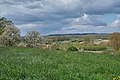
 Landschap in het Pajottenland.jpg 4 608 × 3 072; 1,48 MB
-
 Landschap Pajottenland -Gooik.jpg 5 135 × 3 416; 5,19 MB
-
 Pajottenland (zicht vanuit kasteel Gaasbeek) 01.jpg 5 472 × 3 648; 6,59 MB
-
 Pajottenland (zicht vanuit kasteel Gaasbeek) 02.jpg 5 472 × 3 648; 7,55 MB
-
 Pajottenland (zicht vanuit kasteel Gaasbeek) 03.jpg 5 472 × 3 648; 8,25 MB
-
 Pajottenland (zicht vanuit kasteel Gaasbeek) 04.jpg 5 472 × 3 648; 7,99 MB
-
 Pajottenland (zicht vanuit kasteel Gaasbeek) 05.jpg 5 472 × 3 648; 7,88 MB
-
 Pajottenland (zicht vanuit kasteel Gaasbeek) 06.jpg 5 472 × 3 648; 8,63 MB
-
 Pajottenland (zicht vanuit kasteel Gaasbeek) 07.jpg 5 472 × 3 648; 9,85 MB
-
 Pajottenland (zicht vanuit kasteel Gaasbeek) 08.jpg 5 472 × 3 648; 8,46 MB
-
 Pajottenland (zicht vanuit kasteel Gaasbeek) 09.jpg 5 472 × 3 648; 6,26 MB
-
 Pajottenland (zicht vanuit kasteel Gaasbeek) 10.jpg 5 472 × 3 648; 6,02 MB
-
 Pajottenland (zicht vanuit kasteel Gaasbeek) 11.jpg 5 472 × 3 648; 9,18 MB
-
 Pajottenland Vollezele 2.jpg 2 048 × 922; 298 KB
-
 Pajottenland Vollezele.jpg 2 048 × 922; 289 KB
-
 Pajottenland-Zennevallei.png 270 × 203; 5 KB
-
 Pajottenland.png 270 × 203; 18 KB
-
 Payottenland-PDW-01.jpg 1 566 × 2 386; 2,47 MB
-
 Pletmolen.jpg 2 336 × 4 160; 1,49 MB
-
 Poort Hof te Bodegem.jpg 6 048 × 4 024; 7,37 MB
-
 Populierenweide Pepingen.jpg 4 491 × 1 914; 5,47 MB
-
 Record bier in glas.jpg 4 024 × 6 048; 4,79 MB
-
 Schooltje (basisonderwijs) in Bellingen 01.jpg 2 910 × 4 364; 1,91 MB
-
 Schooltje (basisonderwijs) in Bellingen 02.jpg 3 072 × 4 608; 2,18 MB
-
 Schooltje (basisonderwijs) in Bellingen 03.jpg 2 843 × 4 412; 2,52 MB
-
 Schooltje (basisonderwijs) in Bellingen 04.jpg 4 608 × 3 072; 7,63 MB
-
 Sint Maarten met een duif op zijn schouder.jpg 6 048 × 4 024; 3,17 MB
-
 Sint-Martinuskerk te Sint Martens Bodegem.jpg 4 024 × 6 048; 5,87 MB
-
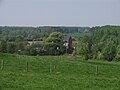
 Vollezele Pajottenland.jpg 2 048 × 922; 384 KB


.jpg)


_Descriptio_geographica_archiepiscopatus_Mechliniensis.gif)


_01.jpg)
_02.jpg)
_03.jpg)
_04.jpg)
_05.jpg)
_06.jpg)
_07.jpg)
_08.jpg)
_09.jpg)
_10.jpg)
_11.jpg)


_in_Bellingen_01.jpg)
_in_Bellingen_02.jpg)
_in_Bellingen_03.jpg)
_in_Bellingen_04.jpg)


