Category:Peelkant 26, Sint Anthonis
Jump to navigation
Jump to search
| Object location | | View all coordinates using: OpenStreetMap |
|---|
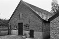
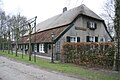
farmhouse in Sint Anthonis, Netherlands  | |||||
| Upload media | |||||
| Instance of | |||||
|---|---|---|---|---|---|
| Location | Sint Anthonis, Land van Cuijk, North Brabant, Netherlands | ||||
| Street address |
| ||||
| Located on street |
| ||||
| Heritage designation |
| ||||
| Inception |
| ||||
 | |||||
|
This is a category about rijksmonument number 31778
|
| Address |
|
Media in category "Peelkant 26, Sint Anthonis"
The following 10 files are in this category, out of 10 total.
-
 Achtergevel zomerhuis - Sint Anthonis - 20023227 - RCE.jpg 1,200 × 788; 229 KB
-
 Linker zijgevel - Sint Anthonis - 20023224 - RCE.jpg 1,200 × 800; 254 KB
-
 Linker zijgevel en achtergevel - Sint Anthonis - 20023225 - RCE.jpg 1,200 × 802; 226 KB
-
 T.T Boerderij Peelkant 26 St Anthonis 31778 (1).JPG 3,264 × 2,448; 3.64 MB
-
 T.T Boerderij Peelkant 26 St Anthonis 31778 (2).JPG 3,264 × 2,448; 3.53 MB
-
 T.T Boerderij Peelkant 26 St Anthonis 31778 (3).JPG 3,264 × 2,448; 3.54 MB
-
 T.T Boerderij Peelkant 26 St Anthonis 31778 (4).JPG 3,264 × 2,448; 3.58 MB
-
 Vloets hoeve.JPG 960 × 640; 150 KB
-
 Voorgevel - Sint Anthonis - 20023223 - RCE.jpg 1,200 × 804; 227 KB
-
 Voorgevel zomerhuis - Sint Anthonis - 20023226 - RCE.jpg 1,200 × 806; 229 KB


.JPG)
.JPG)
.JPG)
.JPG)

