Category:Pensby Hall
Jump to navigation
Jump to search
| Object location | | View all coordinates using: OpenStreetMap |
|---|
Grade II listed house in Pensby, Wirral, Merseyside, UK  | |||||
| Upload media | |||||
| Instance of | |||||
|---|---|---|---|---|---|
| Location | Pensby, Wirral, Merseyside, North West England, England | ||||
| Heritage designation |
| ||||
 | |||||
This is a category about listed building number 1343516. |
Grade II listed dating to 1688, originally a farmhouse buillt by William Glegg for one of his family. Later extended.
Media in category "Pensby Hall"
The following 6 files are in this category, out of 6 total.
-
 Datestone of Pensby Hall.jpg 5,208 × 3,472; 10.21 MB
-
 Gable of Pensby Hall.jpg 4,612 × 3,236; 12.34 MB
-
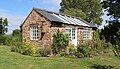 Outhouse of Pensby Hall.jpg 4,976 × 2,876; 11.31 MB
-
 Pensby Hall front elevation.jpg 5,014 × 2,822; 11.65 MB
-
 Pensby Hall front elevation.tif 4,888 × 2,865, 2 pages; 78.64 MB
-
 Rear of Pensby Hall.jpg 4,982 × 2,793; 10.56 MB


