Category:Peperstraat 14, Oudewater
Jump to navigation
Jump to search
| Object location | | View all coordinates using: OpenStreetMap |
|---|
building in Oudewater, Netherlands  | |||||
| Upload media | |||||
| Instance of | |||||
|---|---|---|---|---|---|
| Location | Oudewater, South Holland, Netherlands | ||||
| Street address |
| ||||
| Located on street |
| ||||
| Heritage designation |
| ||||
 | |||||
|
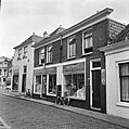
This is a category about rijksmonument number 32076
|
| Address |
|
Media in category "Peperstraat 14, Oudewater"
The following 8 files are in this category, out of 8 total.
-
 2011-06 Peperstraat 14 32076 01.jpg 2,816 × 2,112; 2.81 MB
-
 2011-06 Peperstraat 14 32076 02.jpg 2,112 × 2,816; 2.69 MB
-
 3421 Oudewater, Netherlands - panoramio (46).jpg 2,048 × 1,148; 363 KB
-
 3421 Oudewater, Netherlands - panoramio (67).jpg 2,048 × 1,148; 456 KB
-
 Aanzicht - Oudewater - 20180007 - RCE.jpg 1,195 × 1,200; 286 KB
-
 Achterzijde - Oudewater - 20180008 - RCE.jpg 1,200 × 956; 265 KB
-
 Achterzijde - Oudewater - 20180009 - RCE.jpg 805 × 1,200; 145 KB
-
 Voorgevels - Oudewater - 20180010 - RCE.jpg 1,200 × 809; 221 KB

.jpg)
.jpg)


