Category:Pfarrhaus (Sulzemoos)
Jump to navigation
Jump to search
| Object location | | View all coordinates using: OpenStreetMap |
|---|
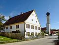
building in Sulzemoos, Upper Bavaria, Germany  | |||||
| Upload media | |||||
| Instance of | |||||
|---|---|---|---|---|---|
| Location | Sulzemoos, Dachau, Upper Bavaria, Bavaria, Germany | ||||
| Street address |
| ||||
| Has part(s) |
| ||||
| Heritage designation | |||||
 | |||||
This is the category of the Bavarian Baudenkmal (cultural heritage monument) with the ID D-1-74-146-4 (Wikidata)
|
Media in category "Pfarrhaus (Sulzemoos)"
The following 9 files are in this category, out of 9 total.
-
 Sulzemoos Pfarrhaus 001 201510 046.JPG 3,853 × 2,949; 2.84 MB
-
 Sulzemoos Pfarrhaus 002 201510 045.JPG 3,934 × 2,919; 3.42 MB
-
 Sulzemoos Pfarrhaus 003 201510 044.JPG 3,124 × 4,181; 3.72 MB
-
 Sulzemoos Pfarrhaus 004 201510 043.JPG 3,585 × 2,905; 2.81 MB
-
 Sulzemoos Pfarrhaus 375.jpg 4,701 × 3,134; 12.39 MB
-
 Sulzemoos Pfarrhaus 376.jpg 3,028 × 4,542; 7.72 MB
-
 Sulzemoos Pfarrhaus 377.jpg 3,071 × 4,607; 8.24 MB
-
 Sulzemoos Pfarrhaus 378.jpg 3,448 × 2,298; 4.14 MB
-
 Sulzemoos Pfarrhaus 379.jpg 4,896 × 3,264; 15.99 MB


