Category:Pfarrkirche Großinzersdorf
Jump to navigation
Jump to search
| Object location | | View all coordinates using: OpenStreetMap |
|---|
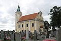
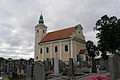
church building in Zistersdorf, Austria   | |||||
| Upload media | |||||
| Instance of | |||||
|---|---|---|---|---|---|
| Location | Großinzersdorf, Zistersdorf, Gänserndorf District, Lower Austria, Austria | ||||
| Street address |
| ||||
| Heritage designation | |||||
 | |||||
Media in category "Pfarrkirche Großinzersdorf"
The following 5 files are in this category, out of 5 total.
-
 Kath. Pfarrkirche hl. Rosalia in Großinzersdorf.jpg 680 × 1,024; 318 KB
-
 Kirche 6613 in A-2225 Großinzersdorf.jpg 4,003 × 4,911; 2.12 MB
-
 Kirche 6613 Innen in A-2225 Großinzersdorf.jpg 6,000 × 3,454; 2.49 MB
-
 NOE Grossinzersdorf Pfarrkirche (bearb Sp).jpg 2,984 × 1,989; 1.67 MB
-
 NOE Grossinzersdorf Pfarrkirche.jpg 3,264 × 2,176; 2.16 MB


.jpg)