Category:Pinchinthorpe
Jump to navigation
Jump to search
village in North Yorkshire, England, UK  | |||||
| Upload media | |||||
| Instance of |
| ||||
|---|---|---|---|---|---|
| Location | Guisborough, Redcar and Cleveland, North Yorkshire, North East England, England | ||||
 | |||||
English: Pinchinthorpe is a small hamlet near Guisborough in Teesside, England. It is a linear settlement spread along the A173. The postcode is TS14 8HE.
Subcategories
This category has only the following subcategory.
R
Media in category "Pinchinthorpe"
The following 38 files are in this category, out of 38 total.
-
 Cleveland Way Marker Stone - geograph.org.uk - 754064.jpg 640 × 427; 53 KB
-
 Frog in Late Winter Snow Flurry - geograph.org.uk - 376139.jpg 426 × 640; 115 KB
-
 Pinchinthorpe - geograph.org.uk - 22882.jpg 640 × 480; 72 KB
-
 Poplar Farm - geograph.org.uk - 610018.jpg 640 × 427; 61 KB
-
 Steps up Bousdale Hill - geograph.org.uk - 375943.jpg 426 × 640; 124 KB
-
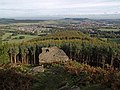
 The summit and the sea - geograph.org.uk - 582900.jpg 640 × 429; 77 KB
-
 Visitor Centre Carpark - geograph.org.uk - 376147.jpg 640 × 426; 89 KB
-
 Young Mixed Woodland - geograph.org.uk - 620496.jpg 640 × 427; 106 KB
-
 A171 - geograph.org.uk - 266775.jpg 640 × 480; 41 KB
-
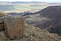
 Boundary Stone, Black Nab - geograph.org.uk - 479674.jpg 640 × 427; 82 KB
-
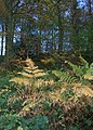
 Bousdale Wood - geograph.org.uk - 677393.jpg 640 × 427; 305 KB
-
 Bousdale Woods - geograph.org.uk - 677395.jpg 640 × 427; 315 KB
-
 Bridleway to Aireyholme Farm - geograph.org.uk - 651426.jpg 640 × 427; 68 KB
-
 Carr Pond - geograph.org.uk - 588073.jpg 640 × 480; 100 KB
-
 Cleveland Way - Corner Slacks Wood - geograph.org.uk - 621754.jpg 640 × 480; 76 KB
-
 East Upsall Farm - geograph.org.uk - 545130.jpg 640 × 427; 74 KB
-
 Electricity Transmission Poles - geograph.org.uk - 715500.jpg 480 × 640; 103 KB
-
 Field Boundary, Near Pinchinthorpe - geograph.org.uk - 620533.jpg 427 × 640; 84 KB
-
 Hanging Stone - geograph.org.uk - 587320.jpg 640 × 480; 106 KB
-
 Hanging Stone - geograph.org.uk - 677249.jpg 640 × 427; 237 KB
-
 Isolated Tree, Roseberry Common - geograph.org.uk - 651422.jpg 640 × 427; 83 KB
-
 Just jump^ - geograph.org.uk - 582908.jpg 640 × 421; 52 KB
-
 Mining Subsidence, Roseberry Mine - geograph.org.uk - 479599.jpg 640 × 427; 84 KB
-
 Mount Pleasant, Upsall Moor - geograph.org.uk - 544197.jpg 640 × 384; 70 KB
-

-
 Park Wood - geograph.org.uk - 610059.jpg 457 × 640; 114 KB
-
 Pinchinthorpe Hall Outbuildings - geograph.org.uk - 22189.jpg 640 × 480; 77 KB
-
 Pond, Near Morton Grange - geograph.org.uk - 545273.jpg 640 × 427; 115 KB
-
 Public Footpath, Upsall Carrs - geograph.org.uk - 544019.jpg 640 × 427; 71 KB
-
 Roseberry Common - geograph.org.uk - 587315.jpg 640 × 480; 98 KB
-
 Roseberry Crags - geograph.org.uk - 504632.jpg 640 × 427; 85 KB
-
 Roseberry Lane - geograph.org.uk - 587296.jpg 640 × 480; 110 KB
-
 Roseberry Topping from Cockshaw Hill - geograph.org.uk - 582885.jpg 431 × 640; 59 KB
-
 Stone Wall, Roseberry Common - geograph.org.uk - 651420.jpg 427 × 640; 73 KB
-
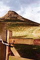 The route to the top - geograph.org.uk - 582909.jpg 432 × 640; 55 KB
-
 Track on Eston Moor - geograph.org.uk - 588072.jpg 640 × 480; 103 KB
-
 Track to High Barnaby Farm - geograph.org.uk - 610040.jpg 640 × 427; 79 KB
-
 Track to Mount House Farm - geograph.org.uk - 620504.jpg 640 × 427; 78 KB


