Built in the 17th and 18th centuries, the bridge of the Camisards, is about 150 m lon. It rests on three main arches and two more connect it the banks of the Gardon.
<nowiki>Puente de los Camisardos; pont des Camisards; bridge of the Camisards; Pont des Camisards; pont des Camisards; Puente de los siglos XVII y XVIII sobre el río Gardon-de-Mialet, en Mialet departamento Gard de Francia; pont français; jembatan di Perancis; міст у Франції; brug in Mialet, Frankrijk; Brücke in Frankreich; bridge in France; جسر في فرنسا; pont e Bro-C'hall; Pont des Camisards (Mialet)</nowiki>


 Mialet-Le pont des Camisards VLG-20120901.jpg 7,464 × 2,821; 6.64 MB
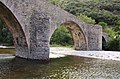 Mialet-Pile du Pont des Camisard VA-20120901.jpg 4,240 × 2,790; 4.11 MB
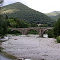 Mialet-Pont des Camisards-20120901.jpg 4,000 × 4,000; 5.61 MB