Category:Ponte de Trajano
Jump to navigation
Jump to search
| Object location | | View all coordinates using: OpenStreetMap |
|---|
bridge in the river tamega in Chaves city, Portugal  .jpg) | |||||
| Upload media | |||||
| Instance of | |||||
|---|---|---|---|---|---|
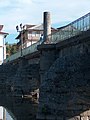
| Made from material | |||||
| Location | Gallaecia, Hispania, Iberian Peninsula, Europe, Northern Hemisphere | ||||
| Crosses | |||||
| Has part(s) | |||||
| Heritage designation | |||||
| Inception |
| ||||
 | |||||
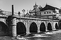
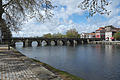
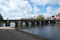
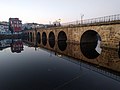
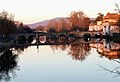
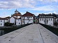
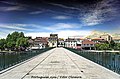
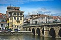
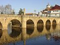
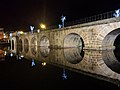
Deutsch: Die Römerbrücke in Chaves (Portugal)
English: The Roman Bridge at Chaves, Portugal
Português: Ponte romana de Trajano em Chaves. Portugal, Vila Real, Chaves, Santa Maria Maior
|
This monument is classified as
Monumento Nacional .It is indexed in the IGESPAR database ( Instituto de Gestão do Património Arquitectónico e Arqueológico ), under the reference 70611.It is indexed in the SIPA database (Sistema de Informação para o Património Arquitectónico) under the reference 3668. |
Subcategories
This category has the following 2 subcategories, out of 2 total.
P
- Padrão dos Povos (10 F)
Pages in category "Ponte de Trajano"
This category contains only the following page.
Media in category "Ponte de Trajano"
The following 51 files are in this category, out of 51 total.
-
 1972 Portugal Chaves (50874998343).jpg 2,981 × 1,804; 1.54 MB
-
 2023 feb chaves verin laza rebordechao-29 (52756294892).jpg 5,760 × 3,840; 12.27 MB
-
 Acquae Flaviae.jpg 1,200 × 819; 636 KB
-
 Chaves (31108519530).jpg 2,430 × 1,609; 390 KB
-
 Chaves DSCN0427 (3055099924).jpg 3,264 × 2,448; 555 KB
-
 Chaves DSCN0428 (3055100996).jpg 3,264 × 2,448; 617 KB
-
 Chaves DSCN0439 (3055111872).jpg 3,264 × 2,448; 527 KB
-
 Chaves DSCN0440 (3054277785).jpg 3,264 × 2,448; 440 KB
-
 Chaves DSCN0441 (3055113788).jpg 3,264 × 2,448; 493 KB
-
 Chaves Ponte de Trajano 302.jpg 4,896 × 3,264; 13.96 MB
-
 Chaves Ponte de Trajano 303.jpg 4,896 × 3,264; 10.16 MB
-
 Chaves Ponte de Trajano 304.jpg 4,896 × 3,264; 10.27 MB
-
 Chaves Rio Tâmega e Madalena Jardim Público.jpg 500 × 261; 102 KB
-
 Ponte de Chaves.jpg 4,288 × 2,848; 3.03 MB
-
 Ponte de Trajano (1).jpg 5,472 × 3,648; 7.03 MB
-
 Ponte de Trajano (2).jpg 5,472 × 3,648; 7.79 MB
-
 Ponte de Trajano - panoramio.jpg 2,288 × 1,712; 2.06 MB
-
 Ponte de Trajano 2.jpg 4,032 × 3,024; 2.22 MB
-
 Ponte de Trajano 3.jpg 4,032 × 3,024; 1.6 MB
-
 Ponte de Trajano 4.jpg 4,032 × 3,024; 842 KB
-
 Ponte de Trajano 5.jpg 4,032 × 3,024; 1.86 MB
-
 Ponte de Trajano 6.jpg 4,032 × 3,024; 1.37 MB
-
 Ponte de Trajano 7.jpg 4,032 × 3,024; 969 KB
-
 Ponte de Trajano 8.jpg 4,032 × 3,024; 1.68 MB
-
 Ponte de Trajano Chaves.jpg 1,490 × 938; 467 KB
-
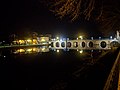
 Ponte de Trajano noite- Chaves.jpg 500 × 375; 62 KB
-
 Ponte de Trajano.jpg 4,032 × 2,761; 916 KB
-
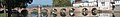 Ponte romana Chaves (cropped).jpg 2,603 × 376; 483 KB
-
 Ponte romana Chaves 01.jpg 2,608 × 1,952; 2.7 MB
-
 Ponte romana Chaves 02.jpg 1,952 × 2,608; 2.33 MB
-
 Ponte Romana Chaves I.jpg 2,304 × 1,728; 760 KB
-
 Ponte Romana Chaves II.jpg 2,304 × 1,728; 747 KB
-
 Ponte romana Chaves.jpg 2,608 × 1,952; 2.36 MB
-
 Ponte romana de Chaves (25387130899).jpg 2,464 × 1,632; 917 KB
-
 Ponte Romana de Trajano - Chaves - Portugal (10994799385).jpg 5,832 × 3,888; 4.51 MB
-
 Ponte Romana de Trajano - Chaves - Portugal (10995005583).jpg 5,787 × 3,710; 3.58 MB
-
 Ponte Romana de Trajano - Chaves - Portugal (11552506265).jpg 5,832 × 3,888; 4.34 MB
-
 Ponte Romana de Trajano - Chaves - Portugal (12929274344).jpg 3,888 × 2,592; 2.12 MB
-
 Ponte Romana de Trajano - Chaves - Portugal (13947602551).jpg 3,888 × 2,592; 2.09 MB
-
 Ponte Romana de Trajano - Chaves - Portugal (31793338443).jpg 3,863 × 2,367; 2.84 MB
-
 Ponte Romana de Trajano - Chaves - Portugal (9003740719).jpg 5,787 × 3,858; 4.36 MB
-
 Ponte Romana de Trajano - Chaves - Portugal (9003749787).jpg 5,694 × 3,741; 8.32 MB
-
 Ponte Romana de Trajano - Chaves - Portugal (9964186466).jpg 5,685 × 3,789; 4.8 MB
-
 Ponte Romana1.jpg 500 × 375; 65 KB
-
 Ponte Trajano em Chaves.jpg 4,032 × 3,024; 1.58 MB
-
 Ponte Trajano no Outono.jpg 4,032 × 3,024; 885 KB
-
 Ponte Trajano á noite.jpg 4,032 × 3,024; 1.59 MB
-
 Ponte Trajano.jpg 4,032 × 3,024; 887 KB
-
 Puente romano (6916571217).jpg 3,264 × 2,448; 1.29 MB
-
 Roman bridge.jpg 560 × 448; 28 KB
-
 Roman bridge3.jpg 402 × 254; 13 KB
.jpg)
.jpg)

.jpg)
.jpg)
.jpg)
.jpg)
.jpg)
.jpg)


.jpg)
.jpg)


.jpg)
.jpg)
.jpg)
.jpg)
.jpg)
.jpg)
.jpg)
.jpg)
.jpg)
.jpg)


.jpg)


.jpg)
Categories:
- Ancient Roman bridges in Portugal
- Stone arch bridges in Portugal
- 2nd-century bridges in Portugal
- Monumentos Nacionais in Vila Real (district)
- Classified monuments in Chaves
- Bridges over the Tâmega
- Gallaecia
- Buildings named after Traianus
- Bridges in Portugal classified as Monumento Nacional
- Bridges in Portugal by name
- Structures in Chaves
- Tâmega river in Chaves
- Bridges named after people in Portugal
- Footbridges over rivers in Portugal
- Footbridges in Vila Real (district)
- Santa Maria Maior (Chaves)
- Via XVII
- Bridges with 16 spans
- Bridges with 12 spans