Category:Public transport maps of Brussels
Jump to navigation
Jump to search
Subcategories
This category has the following 2 subcategories, out of 2 total.
M
- Metro maps of Brussels metro (33 F)
T
Media in category "Public transport maps of Brussels"
The following 40 files are in this category, out of 40 total.
-
 20180615 BRU 5328 (48385250521).jpg 3,264 × 2,448; 1.72 MB
-
 And netplan transp.png 973 × 692; 346 KB
-
 Anneessens.png 270 × 203; 5 KB
-
 Bareel.png 270 × 203; 5 KB
-
 Belgica.png 270 × 203; 5 KB
-
 Berchemstation.png 270 × 203; 5 KB
-
 Beurs.png 270 × 203; 5 KB
-
 Bruxelles - Brussel - Metro - Montgomery (13196349555).jpg 3,000 × 2,250; 2.52 MB
-
 Flagey.png 270 × 203; 5 KB
-
 Haltediamant.png 270 × 203; 5 KB
-
 Halteglobe.png 270 × 203; 5 KB
-
 Haltejanson.png 270 × 203; 5 KB
-
 Heizel.png 270 × 203; 5 KB
-
 Helden.png 270 × 203; 5 KB
-
 Horta.png 270 × 203; 5 KB
-
 Hunderenveld.png 270 × 203; 5 KB
-
 IJzer (metrostation).png 270 × 203; 5 KB
-
 Jettestation.png 270 × 203; 5 KB
-
 Kalevoet.png 270 × 203; 5 KB
-
 Lemonnier.png 270 × 203; 5 KB
-
 Louiza.png 270 × 203; 5 KB
-
 Map of the RER Bruxelles - GEN Brussels.png 2,746 × 2,115; 7.03 MB
-
 Mariejose.png 270 × 203; 5 KB
-
 Meiserstation.png 270 × 203; 5 KB
-
 Merode.png 270 × 203; 5 KB
-
 Noordstation.png 270 × 203; 5 KB
-
 Outline map metro and rail Brussels.svg 1,560 × 1,360; 46 KB
-
 Petillon.png 270 × 203; 5 KB
-
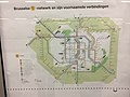
 Plan STIB Berchem-Sainte-Agathe.png 1,080 × 740; 417 KB
-
 Plan STIB Ganshoren.png 1,051 × 673; 376 KB
-
 Plan STIB Jette.png 1,081 × 741; 510 KB
-
 Plan STIB Koekelberg.png 1,223 × 687; 824 KB
-
 RER-2009v2.png 1,000 × 800; 136 KB
-
 Schuman Josaphat tunnel contextual map.jpg 720 × 540; 46 KB
-
 Stuyvenbergh.png 270 × 203; 5 KB
-
 Thomas.png 270 × 203; 5 KB
-
 Trammuseum.png 270 × 203; 5 KB
-
 Weststation.png 270 × 203; 5 KB
-
 Wiener.png 270 × 203; 5 KB
-
 Zuidstation.png 270 × 203; 5 KB
.jpg)


.jpg)


.png)


