Category:Railway bridges in the East Riding of Yorkshire
Jump to navigation
Jump to search
Ceremonial counties of England: Bedfordshire · Berkshire · Buckinghamshire · Cambridgeshire · Cheshire · Cornwall · Cumbria · Derbyshire · Devon · Dorset · Durham · East Riding of Yorkshire · East Sussex · Essex · Gloucestershire · Greater London · Greater Manchester · Hampshire · Herefordshire · Hertfordshire · Kent · Lancashire · Leicestershire · Lincolnshire · Merseyside · Norfolk · North Yorkshire · Northamptonshire · Northumberland · Nottinghamshire · Oxfordshire · Rutland · Shropshire · Somerset · South Yorkshire · Staffordshire · Suffolk · Surrey · Tyne and Wear · Warwickshire · West Midlands · West Sussex · West Yorkshire · Wiltshire · Worcestershire
City-counties: Bristol · City of London
Former historic counties:
Other former counties:
City-counties: Bristol · City of London
Former historic counties:
Other former counties:
Subcategories
This category has the following 5 subcategories, out of 5 total.
G
H
K
Media in category "Railway bridges in the East Riding of Yorkshire"
The following 54 files are in this category, out of 54 total.
-
 Bottoms Road Bridge, Skidby - geograph.org.uk - 624349.jpg 640 × 442; 87 KB
-
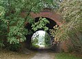
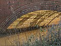 Bridge Arch - geograph.org.uk - 1072683.jpg 640 × 480; 138 KB
-
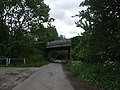
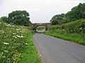 Bridge Near Bempton - geograph.org.uk - 192891.jpg 640 × 480; 117 KB
-
 Bridge No. TJG2-2 - geograph.org.uk - 121399.jpg 640 × 480; 195 KB
-
 Bridge Number 05 - geograph.org.uk - 1562276.jpg 640 × 480; 99 KB
-
 Bridge on Hull and Barnsley Railway between Willerby and Little Weighton 2.jpg 1,024 × 768; 529 KB
-
 Bridge on Hull and Barnsley Railway between Willerby and Little Weighton 4.jpg 1,024 × 768; 543 KB
-
 Bridge on Hull and Barnsley Railway between Willerby and Little Weighton 5.jpg 1,024 × 768; 558 KB
-
 Bridge on Hull and Barnsley Railway between Willerby and Little Weighton.jpg 1,024 × 768; 332 KB
-
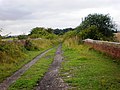
 Bridleway-Farm Track - geograph.org.uk - 126622.jpg 640 × 480; 101 KB
-
 Burstwick Drain east of old railway - geograph.org.uk - 1094009.jpg 640 × 480; 59 KB
-
 Burstwick Drain Railway Bridge - geograph.org.uk - 271804.jpg 477 × 640; 109 KB
-
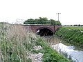 Burstwick Drain Railway Bridge - geograph.org.uk - 407232.jpg 640 × 480; 99 KB
-
 Burstwick Drain railway bridge. - geograph.org.uk - 11949.jpg 640 × 480; 155 KB
-
 Burstwick Drain, east of Hedon - geograph.org.uk - 1107142.jpg 640 × 426; 187 KB
-
 Church Road, North Ferriby - geograph.org.uk - 891661.jpg 640 × 590; 226 KB
-

-
 Disused Railway Bridge, Goodmanham Road - geograph.org.uk - 1563839.jpg 640 × 480; 108 KB
-
 Drain and Bridge on disused railway - geograph.org.uk - 1093991.jpg 640 × 480; 105 KB
-
 Ellerker Clough - geograph.org.uk - 610136.jpg 480 × 640; 85 KB
-
 Ellerker Drain - geograph.org.uk - 1186980.jpg 480 × 640; 103 KB
-
 Footbridge carrying Trans Pennine Trail.jpg 640 × 480; 156 KB
-
 Footpath, ditch and hedge (geograph 5436263).jpg 640 × 426; 75 KB
-
 Goodmanham Dale, Kiplingcotes - geograph.org.uk - 739726.jpg 434 × 640; 96 KB
-
 Goole bridge tower - geograph.org.uk - 1520512.jpg 429 × 640; 208 KB
-
 Gowdall Road Railway Bridge.jpg 640 × 480; 104 KB
-
 Limekiln Lane Railway Bridge - geograph.org.uk - 656400.jpg 640 × 418; 77 KB
-
 Low Mill Lane, North Cave - geograph.org.uk - 596120.jpg 640 × 463; 124 KB
-
 Old Fleet Railway Bridge - geograph.org.uk - 316995.jpg 640 × 478; 117 KB
-
 Old Railway Bridge, Kiplingcotes - geograph.org.uk - 825674.jpg 640 × 425; 254 KB
-
 Railway Bridge Church Road North Ferriby.jpg 640 × 394; 94 KB
-
 Railway Bridge Goodmanham.jpg 640 × 480; 124 KB
-
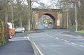
 Railway bridge in Bridlington - geograph.org.uk - 506457.jpg 640 × 480; 139 KB
-
 Railway Bridge near Goodmanham - geograph.org.uk - 1432017.jpg 640 × 480; 79 KB
-
 Railway Bridge near Goodmanham - geograph.org.uk - 632299.jpg 480 × 640; 118 KB
-
 Railway Bridge on Sarah Rhodes Lane - geograph.org.uk - 1366420.jpg 640 × 480; 87 KB
-

-
 Railway Bridge over Catchwater Drain - geograph.org.uk - 1497244.jpg 640 × 480; 86 KB
-
 Railway bridge over Church Road (geograph 5658020).jpg 640 × 480; 80 KB
-
 Railway Bridge over Flamborough Road - geograph.org.uk - 1567010.jpg 640 × 434; 58 KB
-

-
 Railway Bridge, Bridlington - geograph.org.uk - 1209081.jpg 640 × 480; 88 KB
-
 Railway underpass - geograph.org.uk - 1255125.jpg 640 × 480; 71 KB
-
 Red Enholmes railway bridge, Winestead - geograph.org.uk - 196464.jpg 640 × 558; 191 KB
-
 Riplingham Road rail bridge - geograph.org.uk - 609431.jpg 640 × 480; 174 KB
-
 Station approach road, Gilberdyke (geograph 5048843).jpg 1,200 × 799; 509 KB
-
 Successive Transport Systems - geograph.org.uk - 250144.jpg 640 × 480; 102 KB
-
 The Hudson Way from Kiplingcotes - geograph.org.uk - 1436503.jpg 640 × 480; 86 KB
-

-
 The Hull and Hornsea Railway, Swine - geograph.org.uk - 774269.jpg 478 × 640; 112 KB
-
 The Hull to Selby Line - geograph.org.uk - 610145.jpg 640 × 355; 53 KB
-
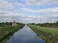 The Market Weighton Canal - geograph.org.uk - 1466215.jpg 640 × 480; 54 KB
-
 The Market Weighton Canal - geograph.org.uk - 250142.jpg 640 × 480; 107 KB
-


.jpg)


_-_geograph.org.uk_-_1774477.jpg)

.jpg)


.jpg)


