Category:Randall's Arch, Newton-le-Willows
Jump to navigation
Jump to search
| Object location | | View all coordinates using: OpenStreetMap |
|---|
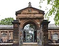
grade II* listed building in Newton-le-Willows, St Helens, Merseyside  | |||||
| Upload media | |||||
| Instance of | |||||
|---|---|---|---|---|---|
| Location | St Helens, Merseyside, North West England, England | ||||
| Heritage designation |
| ||||
 | |||||
Built in the 1780s as the entrance to Haydock Lodge, the home of the Legh family, and moved to High Street, Newton-le-Willows in 1840 as the centrepiece of Newton’s market. It is now an Italian restaurant.
Media in category "Randall's Arch, Newton-le-Willows"
The following 9 files are in this category, out of 9 total.
-
 Newton-le-Willows (34).JPG 4,320 × 3,240; 3.02 MB
-
 Ram's head, Randall's Arch, Newton-le-Willows.jpg 3,296 × 4,637; 10.07 MB
-
 Randall's Arch, Newton-le-Willows 1.jpg 4,607 × 2,316; 14.17 MB
-
 Randall's Arch, Newton-le-Willows 1a.jpg 4,707 × 2,712; 17.57 MB
-
 Randall's Arch, Newton-le-Willows 2.jpg 2,873 × 3,994; 12.41 MB
-
 Randall's Arch, Newton-le-Willows 3.jpg 4,436 × 3,434; 16.62 MB
-

-

-
 Shield, Randall's Arch, Newton-le-Willows.jpg 4,679 × 3,170; 17.57 MB
.JPG)


