Category:Remote views of Bass Rock
Jump to navigation
Jump to search
Media in category "Remote views of Bass Rock"
The following 107 files are in this category, out of 107 total.
-
 2005 Autumn (4000018021).jpg 2,272 × 1,704; 1.03 MB
-
 2005, Birthday Parties (4000187186).jpg 1,704 × 2,272; 813 KB
-
 A wedding ceremony at Tantallon Castle - geograph.org.uk - 916269.jpg 640 × 427; 166 KB
-
 Allemann Fun Sommerausflug 2015 (19000977891).jpg 4,928 × 3,264; 2.37 MB
-
 Bass Rock (1981) - geograph.org.uk - 866557.jpg 640 × 400; 94 KB
-
 Bass Rock (3979720879).jpg 1,600 × 1,043; 213 KB
-
 Bass Rock - geograph.org.uk - 1740401.jpg 663 × 800; 94 KB
-
 Bass Rock - geograph.org.uk - 426596.jpg 640 × 480; 86 KB
-
 Bass Rock - geograph.org.uk - 900787.jpg 640 × 296; 14 KB
-
 Bass Rock 1.jpg 600 × 399; 26 KB
-
 Bass Rock 2.jpg 640 × 480; 58 KB
-
 Bass Rock 4.jpg 640 × 480; 94 KB
-

-
 Bass Rock and Tyninghame woods - geograph.org.uk - 1603133.jpg 640 × 424; 48 KB
-

-
 Bass Rock from Clint Dod - geograph.org.uk - 137237.jpg 640 × 480; 81 KB
-
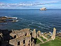
 Bass Rock from courtyard at Tantallon.jpg 2,256 × 1,504; 1.74 MB
-
 Bass Rock from Crail - geograph.org.uk - 950425.jpg 640 × 457; 40 KB
-
 Bass Rock from Dunbar.jpg 5,184 × 3,456; 5.61 MB
-
 Bass Rock from Law.jpg 2,720 × 1,813; 3.64 MB
-
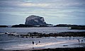
 Bass Rock from North Berwick.jpg 1,280 × 960; 254 KB
-
 Bass Rock from Pittenweem Harbour - geograph.org.uk - 655661.jpg 640 × 480; 31 KB
-
 Bass Rock from Tantallon (7631100).jpg 769 × 504; 406 KB
-
 Bass Rock from Tantallon Castle .jpg 2,580 × 1,932; 615 KB
-
 Bass Rock from Tantallon Castle, East Lothian 1993 (17457851).jpg 1,032 × 1,562; 2.15 MB
-
 Bass Rock from Tantallon Castle.jpg 480 × 640; 29 KB
-
 Bass Rock from Tantallon.jpg 480 × 640; 23 KB
-
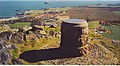
 Bass Rock from the air - geograph.org.uk - 1057182.jpg 640 × 480; 58 KB
-
 Bass Rock from the air - geograph.org.uk - 1523275.jpg 640 × 477; 74 KB
-
 Bass Rock from Yellow Craig - geograph.org.uk - 1011805.jpg 640 × 426; 49 KB
-

-
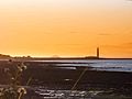
 Bass Rock Sunset.jpg 640 × 480; 497 KB
-
 Bass Rock Tantallon Castle.jpg 640 × 480; 32 KB
-
 Bass Rock, East Lothian, UK, 2014 - panoramio.jpg 3,264 × 2,448; 711 KB
-
 Bass Rock, Firth of Forth, Scotland - Flickr - In Memoriam, PhillipC.jpg 1,358 × 814; 1 MB
-
 Bass Rock, Firth of Forth, Scotland.jpg 1,358 × 814; 1.74 MB
-
 Bass Rock.jpg 2,832 × 2,128; 1.05 MB
-
 Bass rock.jpg 684 × 464; 37 KB
-
 Bassrockfromfife.jpg 640 × 467; 66 KB
-
 Beach, West Links - geograph.org.uk - 945205.jpg 640 × 359; 41 KB
-
 Belhaven Beach - geograph.org.uk - 948161.jpg 435 × 640; 47 KB
-
 Broad Sands at Yellowcraig - geograph.org.uk - 1247845.jpg 640 × 480; 103 KB
-
 Craigleith - geograph.org.uk - 1189630.jpg 640 × 257; 28 KB
-
 Craigleith.jpg 640 × 478; 63 KB
-
 Dunbar-John Muir beach.JPG 1,024 × 768; 704 KB
-
 East Neuk - geograph.org.uk - 901554.jpg 640 × 422; 88 KB
-
 Flickr - law keven - Down....on the beach.....jpg 3,760 × 2,156; 799 KB
-
 Golfers on the 9th tee - geograph.org.uk - 1014310.jpg 640 × 427; 129 KB
-
 Milsey Bay - geograph.org.uk - 229.jpg 640 × 480; 148 KB
-
 Bass Rock 3.jpg 1,600 × 1,200; 397 KB
-
 North Berwick Law and the Bass Rock from Arthur's Seat, Edinburgh.jpg 1,920 × 817; 360 KB
-
 North Berwick, UK - panoramio - Gyula Péter (1).jpg 1,200 × 1,600; 954 KB
-
 Passing the Bass Rock - geograph.org.uk - 964813.jpg 640 × 359; 49 KB
-
 Ploughed field, Auldhame (geograph 3790146).jpg 640 × 480; 265 KB
-
 Ravensheugh Sands - geograph.org.uk - 30770.jpg 640 × 480; 93 KB
-
 Ruins inside Tantallon Castle facing majestic Bass Rock.JPG 3,648 × 2,432; 4.14 MB
-
 Sandy shore near Longskelly Point - geograph.org.uk - 1247896.jpg 640 × 480; 50 KB
-
 Scoughall Rocks - geograph.org.uk - 1115312.jpg 640 × 480; 95 KB
-
 Sea anglers, John Muir Country Park - geograph.org.uk - 1231106.jpg 640 × 426; 46 KB
-
 Seacliff - geograph.org.uk - 1322263.jpg 640 × 360; 70 KB
-
 St Baldred's Cradle - geograph.org.uk - 1226128.jpg 640 × 480; 113 KB
-
 St Baldreds Boat from Great Car, Seacliff (geograph 5070620).jpg 1,024 × 682; 157 KB
-
 Summit of Fidra - geograph.org.uk - 1364140.jpg 640 × 480; 108 KB
-
 Tantallon Castle - geograph.org.uk - 704354.jpg 416 × 640; 87 KB
-
 Tantallon Castle - Scotland.JPG 3,264 × 2,448; 4.25 MB
-
 Tantallon Castle and Bass Rock - geograph.org.uk - 145060.jpg 640 × 480; 104 KB
-
 Tantallon Castle and Bass Rock, East Lothian (7629282).jpg 575 × 344; 221 KB
-
 Tantallon Castle and Bass Rock.jpg 4,425 × 2,950; 5.73 MB
-
 Tantallon Castle and the Bass Rock.jpg 4,032 × 3,024; 6.38 MB
-
-
 Tantallon Castle North Range.jpg 4,032 × 3,024; 7.87 MB
-
 Tantallon Castle wall and Bass Rock.jpg 2,592 × 3,872; 2.96 MB
-
 The 13th, Glen Golf Club - geograph.org.uk - 964194.jpg 640 × 359; 49 KB
-
 The Bass - Flickr - S. Rae.jpg 3,128 × 1,760; 1.42 MB
-
 The Bass Rock from North Berwick, East Lothian, Scotland.jpg 2,231 × 929; 857 KB
-

-
 The Bass Rock, Firth of Forth, by Captain J. W. Anderson.jpg 750 × 480; 78 KB
-
 The Brigantine Reaper Off Bass Rock, by Frederick Tudgay.jpg 1,000 × 651; 442 KB
-
 The coastline by Winterfield Golf Course - geograph.org.uk - 1014342.jpg 417 × 640; 138 KB
-
 The Gegan - geograph.org.uk - 482451.jpg 640 × 427; 65 KB
-
 The Gegan at Seacliff (geograph 3797162).jpg 640 × 427; 189 KB
-
 The Glen Golf Club - geograph.org.uk - 964162.jpg 640 × 359; 50 KB
-

-
 The ruins of Tantallon Castle - geograph.org.uk - 916669.jpg 427 × 640; 121 KB
-

-
 Towards Bass Rock - panoramio.jpg 1,617 × 1,211; 151 KB
-
 View across North Berwick beach - geograph.org.uk - 710321.jpg 640 × 385; 44 KB
-
 View from Tantallon Castle - geograph.org.uk - 1803370.jpg 640 × 427; 44 KB
-
 View of Tantallon Castle and the Bass Rock by Alexander Nasmyth, NGS.JPG 3,088 × 2,056; 2.94 MB
-

-

-

-

-
 View towards Tantallon Castle - geograph.org.uk - 311867.jpg 640 × 425; 30 KB
-
 Viewpoint indicator.jpg 640 × 350; 113 KB
-
 Walkers on The Gegan at Seacliff (geograph 3797167).jpg 640 × 427; 195 KB
-
 Walking along North Berwick beach - geograph.org.uk - 1521916.jpg 418 × 640; 148 KB
-
 Waves on the Belhaven Rocks - geograph.org.uk - 1573287.jpg 640 × 480; 77 KB
-
 West Links, North Berwick - geograph.org.uk - 945192.jpg 640 × 359; 43 KB
-
 Bass Rock and the Leithies - geograph.org.uk - 341067.jpg 640 × 382; 50 KB
-
 Belhaven Bay - geograph.org.uk - 727953.jpg 640 × 419; 52 KB
-
 Bridge at Belhaven Bay - geograph.org.uk - 727938.jpg 640 × 419; 77 KB
-

-
 Historic bike ride - geograph.org.uk - 142640.jpg 500 × 375; 101 KB
-
 Peffer Sands - geograph.org.uk - 583971.jpg 640 × 465; 27 KB
-
 St Baldred's Cross - geograph.org.uk - 169812.jpg 640 × 480; 40 KB
-

.jpg)
.jpg)

.jpg)
_-_geograph.org.uk_-_866557.jpg)
.jpg)


.jpg)

.jpg)


.jpg)

.jpg)


.jpg)


.jpg)


.jpg)


.jpg)


