Category:Richard-Wagner-Gymnasium (Bayreuth)
Jump to navigation
Jump to search
| Object location | | View all coordinates using: OpenStreetMap |
|---|
cultural heritage monument D-4-62-000-382 (0) in Bayreuth, Bavaria  | |||||
| Upload media | |||||
| Instance of | |||||
|---|---|---|---|---|---|
| Location |
| ||||
| Street address |
| ||||
| Heritage designation | |||||
| official website | |||||
 | |||||
This is the category of the Bavarian Baudenkmal (cultural heritage monument) with the ID D-4-62-000-382 (Wikidata)
|
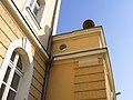
Deutsch: Das Richard-Wagner-Gymnasium (RWG) in Bayreuth (Oberfranken) wurde am 4. Oktober 1867 als "Höhere Töchterschule Bayreuth" gegründet und besteht noch heute. Das Gebäude war seinerzeit Erstbezug und ist zwischenzeitlich erweitert worden. Es befindet sich am Wittelsbacherring 9. Heute ist die Schule ein sprachliches, wirtschafts- und sozialwissenschaftliches Gymnasium. Die Erziehung und Unterrichtung ist heute koedukativ.
English: Richard Wagner High School (RWG) was founded on October 4, 1867 in Bayreuth, Bavaria as "Higher Töchterschule Bayreuth" (private high school for girls) and remains today. The building was newly built at that time and has been extended since then. It is located at Wittelsbacherring 9 in Bayreuth. Today the school is a linguistic, economic, and social science school. The school is now coeducational.
Media in category "Richard-Wagner-Gymnasium (Bayreuth)"
The following 7 files are in this category, out of 7 total.
-
 Bayreuth, Wittelsbacher Ring 9-001.jpg 3,264 × 4,928; 7.52 MB
-
 Bayreuth, Wittelsbacher Ring 9-002.jpg 3,264 × 4,928; 6.6 MB
-
 Bayreuth, Wittelsbacher Ring 9-004.jpg 3,264 × 4,928; 4.96 MB
-
 Bayreuth, Wittelsbacher Ring 9-005.jpg 4,695 × 3,110; 6.28 MB
-
 Bayreuth- Richard-Wagner-Gymnasium 2.jpg 2,304 × 3,072; 2.69 MB
-
 Bayreuth- Richard-Wagner-Gymnasium 3.jpg 3,072 × 2,304; 2.85 MB
-
 Bayreuth-RichardWagnerGymnasium.jpg 970 × 1,147; 647 KB


